 view gallery view gallery N0 km N0 km
|   Montauk State Park, Missouri Montauk State Park, Missouri
in American Guide Series Not quite as rustic today as it was in 1941, is Montauk State Park whose springs form the upper reaches of the Current River in the Missouri Ozarks. Today,it is still known for its rustic Ozarks beauty and fishing for rainbow and brown trout. posted by:  Carpe Diem59 Carpe Diem59 location: Missouri date approved: 11/02/2009 last visited: never |
 view gallery view gallery E6.1 km E6.1 km
|  Nichols Farm District Nichols Farm District
in U.S. National Register of Historic Places Historic Cabin and barns depicting the early 1900's farmsteads in the Ozarks of Missouri posted by: MoOzarksRegionalExplorers location: Missouri date approved: 04/12/2007 last visited: never |
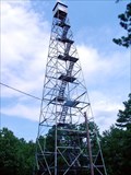 view gallery view galleryN7.2 km |  Montauk Fire Tower Montauk Fire Tower
in Look-Out Towers Montauk Lookout tower Dent Co., Misouri posted by:  Headstone Hunter 1 Headstone Hunter 1 location: Missouri date approved: 08/17/2008 last visited: 08/17/2008 |
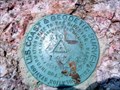 view gallery view galleryN7.2 km |  Zion Triangulation Disk Dent Co., Missouri Zion Triangulation Disk Dent Co., Missouri
in U.S. Benchmarks Zion Triangulation Disk Dent Co., Missouri near the location of Montauk Firetower. posted by: Headstone Hunter 1 location: Missouri date approved: 08/20/2008 last visited: 08/20/2008 |
  SE10.6 km SE10.6 km
| ") Medlock Cave Medlock Cave
in Cave Entrances (Natural) This neat cave enterance in the Ozark National Scenic Waterways National Park is along the Current River. To protect the endangered Bat species which hibranate inside the cave it is closed off with big steel bars just a few feet inside the entrance. posted by: Kat&Rob location: Missouri date approved: 01/22/2007 last visited: 06/14/2012 |
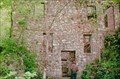 view gallery view gallerySE11.9 km |  Welch Spring Hospital Welch Spring Hospital
in Ghost Towns This was never a town but was an abandonded Hospital that the founder hoped would turn into a thriving location. posted by: Kat&Rob location: Missouri date approved: 01/22/2007 last visited: never |
 view gallery view gallerySE11.9 km | Welch Cave & Hospital in Cave Entrances (Natural) This Cave is surounded by the ruins of a Hospital. It is located on the Current River in the Ozark National Scenic Riverways. Be sure to read the Long Description and look at the web link to find out more. posted by: Kat&Rob location: Missouri date approved: 01/22/2007 last visited: never |
 view gallery view gallery W13.4 km W13.4 km
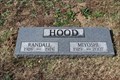
|  Miyoshi Umeki - Boone Creek Cemetery - Licking, MO Miyoshi Umeki - Boone Creek Cemetery - Licking, MO
in Grave of a Famous Person Miyoshi Umeki (Hood) was a Japanese actress who won an Academy Award for her performance in 1957's "Sayonara", and is known to many of us as having played Mrs. Livingston from 1969 to 1972 on "The Courtship of Eddie's Father." posted by: QuarrellaDeVil location: Missouri date approved: 01/25/2018 last visited: 11/02/2017 |
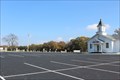
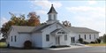 view gallery view galleryW13.5 km |  Boone Creek Baptist Church - Licking, MO Boone Creek Baptist Church - Licking, MO
in Baptist Churches Boone Creek Baptist Church is at 10864 MO 137, Licking, MO. posted by: QuarrellaDeVil location: Missouri date approved: 01/25/2018 last visited: 11/02/2017 |
 view gallery view galleryW13.5 km |  Boone Creek Baptist Church - Licking, MO Boone Creek Baptist Church - Licking, MO
in Country Churches About four-and-a-half miles from town, Boone Creek Baptist Church is at 10864 MO 137, Licking, MO. Sunday services are at 11 AM and 6 PM. posted by: QuarrellaDeVil location: Missouri date approved: 01/25/2018 last visited: 11/02/2017 |
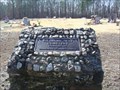
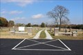 view gallery view galleryW13.5 km |  Boone Creek Cemetery - Licking, MO Boone Creek Cemetery - Licking, MO
in Worldwide Cemeteries The Boone Creek Cemetery is behind the Boone Creek Baptist Church at 10864 MO 137, Licking, MO. Dating to at least the 1860s, it is still active, with nearly 2000 burials. posted by: QuarrellaDeVil location: Missouri date approved: 08/09/2018 last visited: never |
 view gallery view galleryW13.5 km |  Boone Creek Baptist Church and Cemetery - Licking, MO Boone Creek Baptist Church and Cemetery - Licking, MO
in Churchyard Cemeteries Boone Creek Baptist Church is at 10864 MO 137, Licking, MO. Sunday services are at 11 AM and 6 PM. posted by: QuarrellaDeVil location: Missouri date approved: 01/25/2018 last visited: 11/02/2017 |
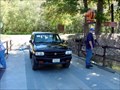 view gallery view gallerySE14.6 km |  Akers Ferry Current River Shannon Co., Missouri Akers Ferry Current River Shannon Co., Missouri
in Ferries and Ferry Landings Akers Ferry Shannon County, Missouri. This is the last ferry operating in the Ozark National Scenic Riverways. posted by: Headstone Hunter 1 location: Missouri date approved: 09/18/2007 last visited: 09/18/2007 |
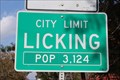 view gallery view galleryW15.3 km |  Licking, MO - Population 3,124 Licking, MO - Population 3,124
in Population Signs Licking, MO, population 3,124 as of this posting. This sign is located on the east side of MO 137, at the southern city limit. Japanese-American actress, Miyoshi Umeki, lived here with her family for awhile. posted by: QuarrellaDeVil location: Missouri date approved: 11/25/2017 last visited: 03/16/2022 |
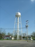 view gallery view galleryW15.6 km |  LICKING - Water Tank LICKING - Water Tank
in Water Towers LICKING,Missouri Water Tank posted by: GEO*Trailblazer 1 location: Missouri date approved: 01/23/2007 last visited: 03/16/2022 |
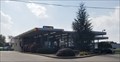 view gallery view galleryW16.4 km |  Sonic Drive In - MO 32 & US 63 - Licking, MO Sonic Drive In - MO 32 & US 63 - Licking, MO
in Sonic Drive In Restaurants Sonic Drive In at 146 West Highway 32 Licking, MO. Phone is 573-674-2126. posted by: QuarrellaDeVil location: Missouri date approved: 11/02/2017 last visited: 11/02/2017 |
 view gallery view gallerySE19.3 km | Devil's Well (AKA) Cave Spring, Shannon Co., Missouri in Cave Entrances (Natural) Devil's Well (AKA) Cave Spring, Shannon Co., Missouri. Both Devil's Well and Wallace Well are karst windows, the first a sinkhole opening onto an underground lake larger than a football field, and the second, a cave containing access to another conduit which flows to the spring. posted by: Headstone Hunter 1 location: Missouri date approved: 04/17/2011 last visited: 02/17/2013 |
SE19.6 km | Cave Spring Cave in Cave Entrances (Natural) This Cave is located within the Ozark National Scenic Riverways National Park along the Current River. This cave is visible and accessable from the Current River. posted by: Kat&Rob location: Missouri date approved: 01/22/2007 last visited: 02/17/2013 |
SE22.4 km | Rock House Cave / Natural Bridge in Cave Entrances (Natural) While this structure is know as more of a cave it has the characteristics of a Natural Bridge. Consiting of a Large Room with two distinct openings this cave sits elevated on a bluff overlooking the Current River in Missouri. posted by: Kat&Rob location: Missouri date approved: 01/22/2007 last visited: never |
 view gallery view galleryE23.3 km | Pilgrims Rest Cemetery, Shannondale, Shannon Co., Missouri in Worldwide Cemeteries Pilgrims Rest Cemetery, Shannondale Shannon Co., Missouri. Est. 1952. 140 graves. posted by: Headstone Hunter 1 location: Missouri date approved: 08/25/2007 last visited: 08/25/2007 |
 view gallery view gallery NE23.5 km NE23.5 km
| Salem, Missouri - Population - 4,950 in Population Signs South city limits.... posted by: YoSam. location: Missouri date approved: 03/02/2020 last visited: never |
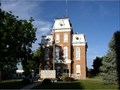 view gallery view galleryNE24.5 km | Dent County Courthouse in U.S. National Register of Historic Places Dent County Courthouse in Salem Missouri posted by: MoOzarksRegionalExplorers location: Missouri date approved: 03/28/2007 last visited: 04/26/2014 |
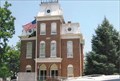 view gallery view galleryNE24.9 km |  Dent County Courthouse - Salem, MO Dent County Courthouse - Salem, MO
in Victorian Style Architecture A courthouse was about 4 blocks north of this site, and was destroyed during the Civil War. This courthouse for Dent County was built 1870. posted by: YoSam. location: Missouri date approved: 02/29/2020 last visited: never |
 view gallery view galleryNE24.9 km |  Dent County, Missouri Dent County, Missouri
in People-Named Places The White River trail had been used by Indians in Dent County. posted by: YoSam. location: Mississippi date approved: 03/06/2020 last visited: never |
 view gallery view galleryNE24.9 km |  Dent County Courthouse ~ Salem, MO Dent County Courthouse ~ Salem, MO
in Courthouses a courthouse was about 4 blocks north of this site, and was destroyed during the Civil War. This courthouse for Dent County was built 1870. posted by: YoSam. location: Missouri date approved: 03/07/2009 last visited: 08/11/2012 |
|