 view gallery view gallery NW9.5 km NW9.5 km
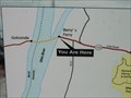
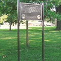
|   Mantle Rock Trail "You Are Here" - Joy, Kentucky Mantle Rock Trail "You Are Here" - Joy, Kentucky
in 'You Are Here' Maps A "You Are Here" sign located at the Mantle Rock Nature Preserve trailhead. posted by:  trailhound1 trailhound1 location: Kentucky date approved: 07/13/2011 last visited: 07/08/2011 |
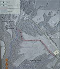
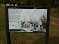
 view gallery view galleryNW9.5 km |  Mantle Rock Trail Mantle Rock Trail
in Hiking and walking trailheads Mantle Rock Nature Preserve located two miles north of Joy, Kentucky on Kentcky Highway 133. posted by: trailhound1 location: Kentucky date approved: 07/08/2011 last visited: 07/08/2011 |
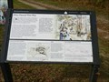
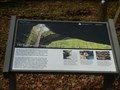 view gallery view galleryNW9.5 km |  The Real Story of Mantle Rock - rural Livingston County, Kentucky The Real Story of Mantle Rock - rural Livingston County, Kentucky
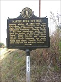
in Trail of Tears This marker, sponsored by the National Park Service and the Nature Conservancy, is located outside the entrance of Mantle Rock Arch. This 215 acre property is located off Hwy 133 near Joy, Kentucky, in rural Livingston County. posted by: iconions location: Kentucky date approved: 11/17/2020 last visited: never |
 view gallery view galleryNW9.5 km |  The Real Story of Mantle Rock - rural Livingston County, Kentucky The Real Story of Mantle Rock - rural Livingston County, Kentucky
in Kentucky Historical Markers This marker, sponsored by the National Park Service and the Nature Conservancy, is located outside the entrance of Mantle Rock Arch. This 215 acre property is located off Hwy 133 near Joy, Kentucky, in rural Livingston County. posted by: iconions location: Kentucky date approved: 11/13/2020 last visited: never |
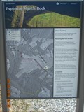
 view gallery view galleryNW9.5 km |  Mantle Rock Archeological District - near Joy, Kentucky Mantle Rock Archeological District - near Joy, Kentucky
in U.S. National Register of Historic Places This 215 acre property is located off Hwy 133 near Joy, Kentucky, in rural Livingston County. posted by: iconions location: Kentucky date approved: 11/13/2020 last visited: never |
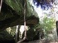 view gallery view galleryNW9.5 km |  Mantle Rock / Livingston County Kentucky Mantle Rock / Livingston County Kentucky
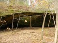
in Natural Arches Mantle Rock Nature Preserve is a 30-foot high natural sandstone bridge spanning 188 feet. posted by: ReedKyCacheFinders location: Kentucky date approved: 09/12/2011 last visited: 11/05/2020 |
 view gallery view galleryNW9.5 km |  Mantle Rock Archeological District - near Joy, Kentucky Mantle Rock Archeological District - near Joy, Kentucky
in Wikipedia Entries This 215 acre property is located off Hwy 133 near Joy, Kentucky, in rural Livingston County. posted by: iconions location: Kentucky date approved: 11/12/2020 last visited: never |
 view gallery view galleryNW9.8 km | Mantle Rock (1/2 mile) in Kentucky Historical Markers Mantle Rock was also campsite for ancient indians. posted by: ReedKyCacheFinders location: Kentucky date approved: 10/18/2008 last visited: 04/02/2011 |
 view gallery view gallery E10.1 km E10.1 km
|  Texaco???Western Auto???Vintage Pumps~Salem, Ky. Texaco???Western Auto???Vintage Pumps~Salem, Ky.
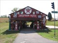
in Vintage Gasoline Pumps Not sure if this was a real station or just thrown together collection posted by: ReedKyCacheFinders location: Kentucky date approved: 10/28/2008 last visited: 11/13/2008 |
 view gallery view galleryNW10.3 km |  Mandy Falls / Marion, Kentucky Mandy Falls / Marion, Kentucky
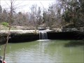
in Waterfalls Mandy Falls is alongside road 133 near the Mantle Rock area in Marion Kentucky. posted by: ReedKyCacheFinders location: Kentucky date approved: 05/04/2009 last visited: 04/02/2011 |
 view gallery view gallery S11.6 km S11.6 km
|  John Montgomery - Smithland, Kentucky John Montgomery - Smithland, Kentucky
in Out of Place Graves Grave of Lieutenant Colonel John Montgomery located at the intersection of highways US 60 and KY 137 outside Smithland, Kentucky. posted by: trailhound1 location: Kentucky date approved: 07/10/2011 last visited: 07/08/2011 |
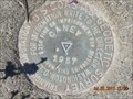 view gallery view galleryS11.6 km |  HB1513 - Caney 1957 HB1513 - Caney 1957
in U.S. Benchmarks A US COAST AND GEODETIC SURVEY TRIANGULATION STATION STAMPED CANEY 1957 NEAR LUCY JEFFERSON MONUMENT. posted by: trailhound1 location: Kentucky date approved: 12/23/2011 last visited: 06/29/2011 |
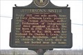 view gallery view galleryS11.6 km | JEFFERSON'S SISTER in Kentucky Historical Markers JEFFERSON'S SISTER on the intersection of hwy 60 and 137 in Livingston County, Kentucky posted by: ReedKyCacheFinders location: Kentucky date approved: 04/27/2009 last visited: 04/02/2011 |
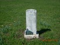
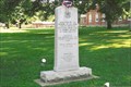
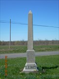 view gallery view galleryS11.6 km |  Lucy Jefferson Lewis - Smithland, Kentucky Lucy Jefferson Lewis - Smithland, Kentucky
in Obelisks Obelisk dedicated to the memory of Lucy Jefferson Lewis, sister of President Thomas Jefferson, outside Smithland, Kentucky at the intersection of U.S. 60 and KY 137. posted by: trailhound1 location: Kentucky date approved: 07/07/2011 last visited: 07/08/2011 |
 view gallery view galleryNW13 km | They Passed This Way - rural Livingston County, Kentucky in Trail of Tears This National Park Service / Trail of Tears Association marker is at the site of the former Berry's Ferry - a major crossing point of the Ohio River before the Civil War. Located at the end of Hwy 133 in rural Livingston County, Kentucky. posted by: iconions location: Kentucky date approved: 11/17/2020 last visited: never |
 view gallery view galleryNW13 km | They Passed This Way - rural Livingston County, Kentucky in Kentucky Historical Markers This National Park Service / Trail of Tears Association marker is at the site of the former Berry's Ferry - a major crossing point of the Ohio River before the Civil War. Located at the end of Hwy 133 in rural Livingston County, Kentucky. posted by: iconions location: Kentucky date approved: 11/21/2020 last visited: 11/22/2020 |
 view gallery view galleryNW13 km | Imagine the Scene - rural Livingston County, Kentucky in Kentucky Historical Markers This National Park Service / Trail of Tears Association marker is at the site of the former Berry's Ferry - a major crossing point of the Ohio River before the Civil War. Located at the end of Hwy 133 in rural Livingston County, Kentucky. posted by: iconions location: Kentucky date approved: 11/21/2020 last visited: 11/22/2020 |
 view gallery view galleryNW13 km | Imagine the Scene - rural Livingston County, Kentucky in Trail of Tears This National Park Service / Trail of Tears Association marker is at the site of the former Berry's Ferry - a major crossing point of the Ohio River before the Civil War. Located at the end of Hwy 133 in rural Livingston County, Kentucky. posted by: iconions location: Kentucky date approved: 11/17/2020 last visited: never |
 view gallery view galleryNW13 km | 'You Are Here' - Berry's Ferry - rural Livingston County, Kentucky in 'You Are Here' Maps This National Park Service / Trail of Tears Association marker is at the site of the former Berry's Ferry - a major crossing point of the Ohio River before the Civil War. Located at the end of Hwy 133 in rural Livingston County, Kentucky. posted by: iconions location: Kentucky date approved: 11/16/2020 last visited: never |
 view gallery view galleryNW13.5 km |  Lewis and Clark Expedition ~ Golconda, IL Lewis and Clark Expedition ~ Golconda, IL
in Lewis and Clark Trail A series of markers in Southern Illinois, at the various stops made by the expedition. posted by: YoSam. location: Illinois date approved: 11/10/2009 last visited: never |
 view gallery view galleryNW13.5 km |  Lewis and Clark Expedition ~ Golconda, IL Lewis and Clark Expedition ~ Golconda, IL
in Illinois Historical Markers A series of markers in Southern Illinois, at the various stops made by the expedition. posted by: YoSam. location: Illinois date approved: 11/10/2009 last visited: never |
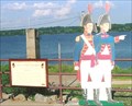
 view gallery view galleryNW13.5 km |  Lewis and Clark - Golconda, IL Lewis and Clark - Golconda, IL
in Silhouette Public Art Sculptures Pointing again and seem to be saying: "You want us to go DOWN THERE?" posted by: YoSam. location: Illinois date approved: 05/07/2015 last visited: never |
 view gallery view galleryNW13.7 km | Lewis and Clark in Illinois ~ Golconda, IL in Illinois Historical Markers One of a series of markers along the Ohio and Mississippi Rivers, and the Expedition made is way to the confluence of the Missouri and Mississippi Rivers. posted by: YoSam. location: Illinois date approved: 11/10/2009 last visited: never |
 view gallery view galleryNW13.7 km | Lewis and Clark in Illinois ~ Golconda, IL in Lewis and Clark Trail One of a series of markers along the Ohio and Mississippi Rivers, and the Expedition made is way to the confluence of the Missouri and Mississippi Rivers. posted by: YoSam. location: Illinois date approved: 11/10/2009 last visited: never |
 view gallery view galleryNW13.7 km |  Pope County Veterans Memorial, Golconda, IL Pope County Veterans Memorial, Golconda, IL
in Non-Specific Veteran Memorials Small Illinois river town, with huge and wide and tree covered courthouse lawn. posted by: YoSam. location: Illinois date approved: 07/06/2008 last visited: 04/11/2009 |
|