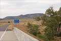
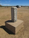
 view gallery view gallery E8.2 km E8.2 km
|   New Mexico Border on highway NM-456 New Mexico Border on highway NM-456
in Border Crossings New Mexico Border on highway NM-456 posted by:  misfitt misfitt location: New Mexico date approved: 02/15/2008 last visited: 06/01/2007 |
 view gallery view galleryE8.4 km |  Black Mesa - near Kenton, OK Black Mesa - near Kenton, OK
in Mountain Summits The highest point in the state of Oklahoma, on Black Mesa, north of Kenton, OK. posted by:  The Snowdog The Snowdog location: Oklahoma date approved: 08/31/2018 last visited: never |
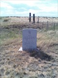
 view gallery view galleryE8.4 km |  Black Mesa High Point - Kenton, OK Black Mesa High Point - Kenton, OK
in Summit Registers Summit register atop Black Mesa, at the highest point in Oklahoma. posted by: The Snowdog location: Oklahoma date approved: 08/27/2018 last visited: never |
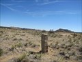
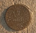 view gallery view galleryE8.4 km |  GL1426 (OSHD BM 4972) on Black Mesa - near Kenton, OK GL1426 (OSHD BM 4972) on Black Mesa - near Kenton, OK
in U.S. Benchmarks State of Oklahoma Highways Elevation Disk atop Black Mesa, north of Kenton, OK posted by: The Snowdog location: Oklahoma date approved: 07/06/2018 last visited: never |
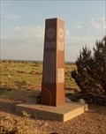
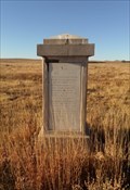
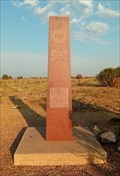 view gallery view galleryE8.4 km | GL1425 (OK HIGH PT MON) on Black Mesa - near Kenton, OK in U.S. Benchmarks Granite obelisk atop Black Mesa, near Kenton, OK posted by: The Snowdog location: Oklahoma date approved: 07/16/2018 last visited: never |
 view gallery view galleryE8.4 km |  Black Mesa - Kenton, OK Black Mesa - Kenton, OK
in American Guide Series Black Mesa, the highest point in the state, is described in the WPA Guide to 1930s Oklahoma - near Kenton, Oklahoma. posted by: The Snowdog location: Oklahoma date approved: 11/23/2021 last visited: never |
 view gallery view galleryE8.4 km |  Oklahoma High Point (Black Mesa) Oklahoma High Point (Black Mesa)
in Geographic High Points Though it is not the highest point of the mesa itself, this spot on Black Mesa is the highest point in the State of Oklahoma. posted by: madmallard location: Oklahoma date approved: 03/24/2011 last visited: 07/05/2018 |
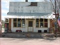 view gallery view galleryE11.4 km |  Kenton Mercantile Restaurant Kenton Mercantile Restaurant
in Classic BBQ and Sandwich Joints The best burgers in Kenton! Closed on Tuesdays. Under new management as of April 28, 2007. posted by: the Tribe of Two location: Oklahoma date approved: 04/29/2007 last visited: 07/05/2018 |
 view gallery view galleryE11.4 km |  Kenton Mercantile WiFi Kenton Mercantile WiFi
in Wi-Fi Hotspots One of the last of the old small-town general stores. posted by: the Tribe of Two location: Oklahoma date approved: 04/29/2007 last visited: 07/05/2018 |
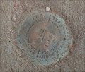 view gallery view galleryE11.7 km | GL0356 (K 12) at the Kenton Union Grade School - Kenton, OK in U.S. Benchmarks U.S. Coast and Geodesic Survey Benchmark Disk on an old school house in Kenton, OK posted by: The Snowdog location: Oklahoma date approved: 07/06/2018 last visited: never |
 view gallery view gallery NE12.1 km NE12.1 km
|  Colorado - New Mexico - Oklahoma Tri-Point Colorado - New Mexico - Oklahoma Tri-Point
in Tripoints and Multipoints Tri-point for Colorado - New Mexico - Oklahoma located north northwest of Kenton, Oklahoma. posted by:  BruceS BruceS location: Colorado date approved: 03/31/2012 last visited: 07/05/2018 |
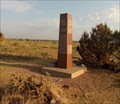
 view gallery view galleryNE12.1 km |  Colorado - New Mexico - Oklahoma Tri-Point Colorado - New Mexico - Oklahoma Tri-Point
in U.S. Historic Survey Stones and Monuments Tri-point monument marking the border of Colorado, New Mexico and Oklahoma. posted by: BruceS location: Colorado date approved: 04/13/2012 last visited: 07/05/2018 |
 view gallery view galleryNE12.1 km | BOUNDARY MI COR CO NM OK RESET in U.S. Benchmarks Tri-point monument marking the border of Colorado, New Mexico and Oklahoma. posted by: BruceS location: Colorado date approved: 04/13/2012 last visited: 07/05/2018 |
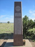
 view gallery view galleryNE12.2 km | BOUNDARY MI COR OLD CO NM OK in U.S. Benchmarks Survey stone place in 1881 marking the southeast corner of Colorado thus the tri-point of three states located .2 miles north of the current tri-point posted by: BruceS location: Colorado date approved: 04/11/2012 last visited: 07/05/2018 |
 view gallery view galleryNE12.2 km | Old Colorado - New Mexico - Oklahoma Tri-Point Stone in U.S. Historic Survey Stones and Monuments Survey stone place in 1881 marking the southeast corner of Colorado thus the tri-point of three states located .2 miles north of the current tri-point stone. posted by: BruceS location: Colorado date approved: 04/12/2012 last visited: 07/05/2018 |
 view gallery view galleryE13.2 km |  Dinosaur Tracks - Black Mesa, OK Dinosaur Tracks - Black Mesa, OK
in Official Local Tourism Attractions These dinosaur tracks have been preserved in a sandstone strata next to Carrizo Creek - near Black Mesa, Oklahoma. posted by: The Snowdog location: Oklahoma date approved: 06/26/2021 last visited: never |
 view gallery view galleryE13.2 km |  Dinosaur Tracks - Black Mesa, OK Dinosaur Tracks - Black Mesa, OK
in Petrosomatoglyphs These dinosaur tracks have been preserved in a sandstone strata next to Carrizo Creek - near Black Mesa, Oklahoma. posted by: The Snowdog location: Oklahoma date approved: 06/25/2021 last visited: never |
 view gallery view gallery S23.5 km S23.5 km
|  Sante Fe Trail - New Mexico/Oklahoma border Sante Fe Trail - New Mexico/Oklahoma border
in Wagon Roads and Trails Sante Fe Trail ruts where it crosses from Oklahoma to New Mexico posted by: countrydirt location: New Mexico date approved: 06/13/2009 last visited: 07/05/2018 |
 view gallery view galleryS25.3 km |  July 4, 1831 - Union County, NM July 4, 1831 - Union County, NM
in New Mexico Historical Markers A stone monument erected in 1921 commemorating the first "authentic" Fourth of July celebration in present-day Union County, New Mexico posted by: The Snowdog location: New Mexico date approved: 07/09/2020 last visited: never |
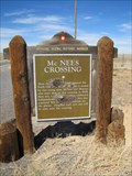 view gallery view galleryS25.6 km | McNees Crossing in New Mexico Historical Markers Historical marker along New Mexico Hwy 406 marking a location along the Santa Fe trail. posted by: BruceS location: New Mexico date approved: 03/31/2012 last visited: 10/26/2019 |
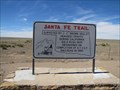
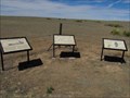 view gallery view gallery SE29.3 km SE29.3 km
|  Santa Fe Trail Santa Fe Trail
in Oklahoma Historical Markers Set of three informational markers about the Santa Fe Trail along Hwy 325 northwest of Boise City, Oklahoma. posted by: BruceS location: Oklahoma date approved: 04/12/2012 last visited: 07/04/2018 |
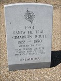 view gallery view gallerySE29.3 km | Santa Fe Trail - Cimarron Route in Oklahoma Historical Markers Stone marker placed the the Daughters of the American Revolution marking route of Santa Fe Trail. posted by: BruceS location: Oklahoma date approved: 04/13/2012 last visited: 07/04/2018 |
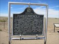 view gallery view gallerySE29.3 km | Fort Nichols in Oklahoma Historical Markers Marker giving history of fort along the Santa Fe Trail located at highway pull off along Hwy 325 northwest of Boise City, Oklahoma posted by: BruceS location: Oklahoma date approved: 04/13/2012 last visited: 07/04/2018 |
 view gallery view gallerySE29.5 km | Santa Fe Trail in Oklahoma Historical Markers Marker giving brief information of Santa Fe Trail along Hwy 325. posted by: BruceS location: Oklahoma date approved: 04/11/2012 last visited: 07/04/2018 |
 view gallery view gallerySE31.4 km |  Box Turtle Crossing - near Kenton, OK Box Turtle Crossing - near Kenton, OK
in Turtle Crossings Box Turtle crossing a two lane road near Kenton, OK posted by: The Snowdog location: Oklahoma date approved: 07/06/2018 last visited: 07/06/2018 |
|