 view gallery view gallery N1.1 km N1.1 km
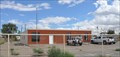
|   Shiprock, New Mexico 87420 (Former) Shiprock, New Mexico 87420 (Former)
in U.S. Post Offices This former Post Office is located on US Highway 491 in the northern reaches of Shiprock, New Mexico. posted by:  brwhiz brwhiz location: New Mexico date approved: 11/02/2011 last visited: never |
 view gallery view gallery SW1.9 km SW1.9 km
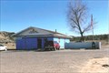
|  McDonalds Free WiFi ~ Shiprock, New Mexico McDonalds Free WiFi ~ Shiprock, New Mexico
in Wi-Fi Hotspots Free WiFi Served Daily at the McDonalds at the junction of US Highways 64 & 491 in Shiprock, New Mexico. posted by: brwhiz location: New Mexico date approved: 11/07/2012 last visited: never |
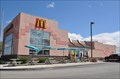 view gallery view gallerySW1.9 km |  McDonalds ~ Shiprock, New Mexico McDonalds ~ Shiprock, New Mexico
in McDonald's Restaurants This McDonalds is located at the junction of US Highways 64 & 491 in Shiprock, New Mexico. posted by: brwhiz location: New Mexico date approved: 11/21/2012 last visited: never |
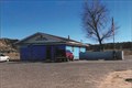
 view gallery view gallerySW2.3 km | Shiprock, New Mexico 87420 in U.S. Post Offices This Post Office is located at 91 Highway 491 South in Shiprock, New Mexico. posted by: brwhiz location: New Mexico date approved: 11/02/2011 last visited: never |
 view gallery view gallery E15.1 km E15.1 km
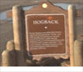
|  Hogback NM Hogback NM
in New Mexico Historical Markers Hogback Historic Marker posted by: kingbee location: New Mexico date approved: 03/11/2009 last visited: 10/30/2015 |
 view gallery view gallerySW17.7 km |  Shiprock - Shiprock, NM Shiprock - Shiprock, NM
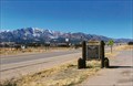
in U.S. National Natural Landmarks Shiprock is significant in the Navajo religion & mythology and was designated a U.S. National Natural Landmark in May 1975. The parking coords takes you up close and personal to the radiating dike in a roadcut along Red Rock Hwy. posted by:  DopeyDuck DopeyDuck location: New Mexico date approved: 06/15/2009 last visited: 03/04/2019 |
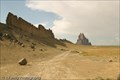 view gallery view gallerySW17.7 km |  Shiprock along Rte 666 - Shiprock, NM Shiprock along Rte 666 - Shiprock, NM
in Satellite Imagery Oddities Shiprock is an exposed volcanic neck towering 1400ft above the surrounding plain, accompanied by radiating dikes. It was designated a U.S. National Natural Landmark in May 1975. posted by: DopeyDuck location: New Mexico date approved: 09/19/2009 last visited: 03/04/2019 |
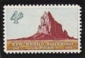 view gallery view gallerySW18 km |  Ship Rock, New Mexico Ship Rock, New Mexico
in Philatelic Photographs The iconic landform known as Ship Rock is shown on this 1962 stamp celebrating 50 years of New Mexico statehood. posted by: hykesj location: New Mexico date approved: 07/13/2018 last visited: 03/04/2019 |
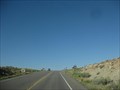
 view gallery view galleryN23.7 km |  Rt 666 into New Mexico Rt 666 into New Mexico
in Border Crossings Southbound Rt 666 (now called 491) into New Mexico from Colorado. posted by: 94RedRover location: New Mexico date approved: 03/06/2008 last visited: 02/28/2009 |
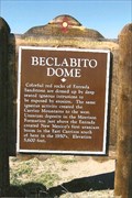 view gallery view gallery W29.5 km W29.5 km
| Beclabito Dome in New Mexico Historical Markers Leaving four corners, this marker is just across the AZ-NM border. posted by: YoSam. location: New Mexico date approved: 03/06/2009 last visited: 03/06/2019 |
 view gallery view galleryW29.5 km |  Beclabito Dome - San Juan County, NM Beclabito Dome - San Juan County, NM
in 'You Are Here' Maps You are here, identifies you spot on the hwy and in line to very the dome. posted by: YoSam. location: New Mexico date approved: 11/30/2013 last visited: 03/06/2019 |
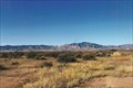
 view gallery view galleryW29.5 km | Beclabito Dome - Beclabito, NM in Satellite Imagery Oddities Baclabito, or Navajo Name is Bitl''aa bito (Water Beneath), is a pink sandstone mounds (peak) that really stands out. posted by: YoSam. location: New Mexico date approved: 12/03/2013 last visited: 03/06/2019 |
 view gallery view galleryW29.5 km |  Beclabito Dome - Beclabito, NM Beclabito Dome - Beclabito, NM
in Places of Geologic Significance Formation cause by magma rising, but not breaking through posted by: YoSam. location: New Mexico date approved: 04/04/2019 last visited: never |
 view gallery view galleryE36.7 km | Farmington in New Mexico Historical Markers City marker as you enter from the west. posted by: YoSam. location: New Mexico date approved: 03/04/2009 last visited: 09/22/2010 |
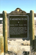 view gallery view galleryE36.7 km |  Farmington NM--population 46000 Farmington NM--population 46000
in Population Signs Farmington NM information posted by: kingbee location: New Mexico date approved: 02/15/2012 last visited: 01/29/2009 |
 view gallery view galleryE36.7 km |  Farmington NM elevation 5395ft Farmington NM elevation 5395ft
in Elevation Signs An information sign posted by: kingbee location: New Mexico date approved: 02/14/2012 last visited: 01/29/2009 |
 view gallery view galleryW37 km |  Teec Nos Pos, AZ Teec Nos Pos, AZ
in Letters on Hills Located on the south side of town, a mesa has the town name written on it. posted by: ChapterhouseInc location: Arizona date approved: 09/21/2011 last visited: 01/20/2009 |
 view gallery view galleryW38.3 km | Teecnospos, AZ - 86514 in U.S. Post Offices Run together by the post office, the towns name is actually: Teec Nos Pos. posted by: YoSam. location: Arizona date approved: 04/03/2009 last visited: 07/31/2011 |
 view gallery view galleryW38.3 km |  Teec Nos Pos, Arizona Teec Nos Pos, Arizona
in Wikipedia Entries In the Nations they are not called towns, or villages or cities, they are called "Chapters" posted by: YoSam. location: Arizona date approved: 07/06/2016 last visited: never |
 view gallery view gallery NW38.5 km NW38.5 km
| CO/NM on US 160 - Four Corners in Border Crossings Going south toward the Four Corners monument US 160 passes between Colorado and New Mexico. posted by: ChapterhouseInc location: Colorado date approved: 09/21/2011 last visited: 05/28/2018 |
 view gallery view galleryNW38.6 km | NM/AZ on US 160 - Four Corners in Border Crossings Going north toward the Four Corners monument US 160 passes between Arizona and New Mexico. posted by: ChapterhouseInc location: New Mexico date approved: 09/21/2011 last visited: 03/06/2019 |
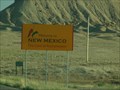
 view gallery view galleryNW38.8 km |  Navajo Reservation Navajo Reservation
in Nations Within Nations This entrance to the Navajo Nation is located on the Arizona-New Mexico border in the Four Corners area. posted by: Team Min Dawg location: Arizona date approved: 08/21/2009 last visited: 04/24/2022 |
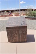
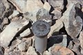 view gallery view galleryNW39.1 km |  Sec 10/11 T 32N R 21W Corner BM -- at Four Corners Monument CO Sec 10/11 T 32N R 21W Corner BM -- at Four Corners Monument CO
in U.S. Benchmarks A pipe-cap section corner set by the US Bureau of Land Management, US Department of the Interior, and the Navajo Nation on the border of Colorado and New Mexico near the Four Corners Monument posted by: Benchmark Blasterz location: Colorado date approved: 08/23/2014 last visited: 08/26/2014 |
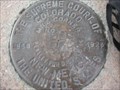 view gallery view galleryNW39.1 km | U.S. Supreme Court, Colorado-New Mexico Mile Corner No. 330 in U.S. Benchmarks Supreme Court of the United States Colorado-New Mexico boundary marker. posted by: Grasshoppers&Ant location: Colorado date approved: 08/02/2007 last visited: 01/27/2020 |
 view gallery view galleryNW39.3 km | New Mexico National Society of Professional Engineers Historic Marker -- nr Teec Nos Pos AZ in New Mexico Historical Markers One of three historic markers erected by the National Society of Professional Engineers at the Four Corners Monument, one each in AZ, NM, and CO, relating the surveying history of this area. posted by: Benchmark Blasterz location: New Mexico date approved: 08/23/2014 last visited: 07/26/2023 |
|