 view gallery view gallery SW11.9 km SW11.9 km
|   Taos Ski Valley, NM 87525 Taos Ski Valley, NM 87525
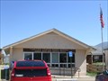
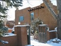
in U.S. Post Offices The Taos Ski Valley Post Office is located near the town's center in a building complex that features shops, offices, and other tourism-centered businesses. posted by:  macdonr macdonr location: New Mexico date approved: 08/24/2008 last visited: never |
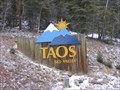 view gallery view gallerySW12.1 km |  Taos Ski Valley Taos Ski Valley
in Winter Sports Locations Taos is one of the world's most unique and picturesque ski resorts. It is a place where one can escape into the ancient cultures of the Southwest or explore the side of a vast mountain that has been opened up for skiing but not tamed.
posted by:  RakeInTheCache RakeInTheCache location: New Mexico date approved: 12/20/2006 last visited: 07/29/2020 |
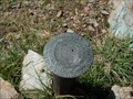 view gallery view gallery E14.5 km E14.5 km
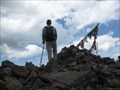
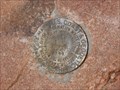
|  Baldy Mountain Azimuth BM Baldy Mountain Azimuth BM
in U.S. Benchmarks An Azimuth benchmark on the north shoulder of Baldy Mountain, outside of Eagle's Nest, NM, posted by: losthiker location: New Mexico date approved: 08/10/2007 last visited: 07/17/2003 |
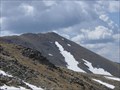
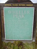
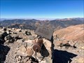 view gallery view gallery S14.6 km S14.6 km
|  Highest Point in New Mexico (Wheeler Peak) Highest Point in New Mexico (Wheeler Peak)
in Geographic High Points At an elevation of 13,161 ft., the summit of Wheeler Peak, in the Sangre de Cristo Mountains, is the highest point in the state of New Mexico. posted by: hykesj location: New Mexico date approved: 10/22/2023 last visited: 07/16/2019 |
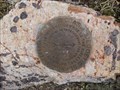
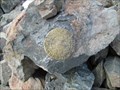 view gallery view galleryS14.6 km | WHEELER Reference Mark - Taos County, New Mexico in U.S. Benchmarks This is one of the reference marks for USGS benchmark WHEELER, located atop Wheeler Peak. posted by: Tom.dog location: New Mexico date approved: 11/16/2022 last visited: 07/16/2019 |
 view gallery view galleryS14.6 km |  Wheeler Peak (New Mexico) Wheeler Peak (New Mexico)
in Wikipedia Entries Wheeler Peak is the highest peak in New Mexico posted by:  Web-ling Web-ling location: New Mexico date approved: 12/04/2009 last visited: 07/16/2023 |
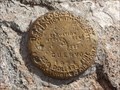
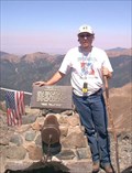 view gallery view galleryS14.6 km |  Wheeler Peak - Highest in New Mexico Wheeler Peak - Highest in New Mexico
in Summit Registers The highest point in New Mexico! posted by: Web-ling location: New Mexico date approved: 04/03/2006 last visited: 07/16/2019 |
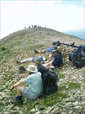
 view gallery view gallerySW15 km |  Kachina Peak Kachina Peak
in Mountain Summits Kachina Peak posted by: rybozz location: New Mexico date approved: 07/20/2009 last visited: never |
 view gallery view gallery SE15.4 km SE15.4 km
| Baldy Mountain - Philmont Scout Ranch in Mountain Summits The Second highest peak, rugged, mountainous ranch located near the town of Cimarron, New Mexico in the Sangre de Cristo Range of the Rocky Mountains. posted by: spazin location: New Mexico date approved: 07/14/2006 last visited: 08/08/1970 |
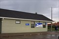
 view gallery view gallerySE17.2 km | Eagle Nest, NM 87718 in U.S. Post Offices Caught this one while geocaching on day off from Philmont Training Center. posted by: SM741 location: New Mexico date approved: 12/13/2008 last visited: 07/20/2015 |
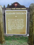 view gallery view gallerySE17.2 km |  Elizabethtown Elizabethtown
in New Mexico Historical Markers A New Mexico OSHM on the northeast corner of US-64 and NM-38. posted by: leadhiker location: New Mexico date approved: 10/27/2011 last visited: never |
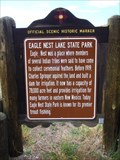 view gallery view gallerySE19.8 km | Eagle Nest Lake State Park in New Mexico Historical Markers A New Mexico OSHM on US-64 at milepost 287. posted by: leadhiker location: New Mexico date approved: 10/27/2011 last visited: 07/28/2020 |
 view gallery view gallery W20.1 km W20.1 km
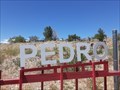
|  San Pedro Cemetery - Questa, NM San Pedro Cemetery - Questa, NM
in Worldwide Cemeteries This small cemetery is the final rest to about one hundred and fifty souls; in Questa, New Mexico. posted by: The Snowdog location: New Mexico date approved: 11/08/2020 last visited: never |
 view gallery view gallerySE21.4 km | Wheeler Peak in New Mexico Historical Markers A New Mexico OSHM on US-64 at milepost 282. posted by: leadhiker location: New Mexico date approved: 10/27/2011 last visited: 08/09/2014 |
 view gallery view gallery NE21.4 km NE21.4 km
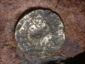
| CUERVO NO 2 - Colfax County, New Mexico in U.S. Benchmarks A USGS-installed U.S. Coast and Geodetic Survey reference mark on the summit of Little Costilla Peak, New Mexico. posted by: Tom.dog location: New Mexico date approved: 10/30/2022 last visited: never |
 view gallery view galleryNE21.4 km | CUERVO (GM0770) - Colfax County, New Mexico in U.S. Benchmarks A USGS benchmark on the summit of Little Costilla Peak, New Mexico. posted by: Tom.dog location: New Mexico date approved: 10/30/2022 last visited: never |
 view gallery view gallerySW25.3 km | Arroyo Seco, NM 87514 in U.S. Post Offices The Arroyo Seco Post Office is located in a standalone building. posted by: macdonr location: New Mexico date approved: 08/24/2008 last visited: 09/29/2012 |
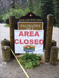 view gallery view gallerySE25.6 km | Palisades Sill in New Mexico Historical Markers A New Mexico OSHM on US-64 at milepost 294. posted by: leadhiker location: New Mexico date approved: 10/27/2011 last visited: 07/08/2023 |
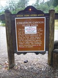 view gallery view gallerySE26.2 km | Cimarron Canyon State Park in New Mexico Historical Markers A New Mexico OSHM on US-64 at milepost 296. posted by: leadhiker location: New Mexico date approved: 10/27/2011 last visited: never |
 view gallery view galleryS27.8 km |  Vietnam War Memorial, State Park, Angel Fire, NM, USA Vietnam War Memorial, State Park, Angel Fire, NM, USA
in Vietnam War Memorials Vietnam Veterans Memorial State Park, Angel Fire, New Mexico. posted by: HANSENNI location: New Mexico date approved: 05/13/2009 last visited: 04/08/2007 |
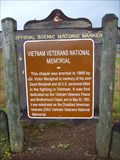 view gallery view galleryS28.2 km | Vietnam Veterans National Memorial in New Mexico Historical Markers A New Mexico OSHM on US-64 at milepost 277. posted by: leadhiker location: New Mexico date approved: 10/27/2011 last visited: 04/08/2007 |
 view gallery view gallerySW28.6 km | Lawrence Ranch - Arroyo Hondo, NM in New Mexico Historical Markers This New Mexico Historical Marker is at the intersection of Highway 522 and Lawrence Ranch Road, about three miles north of Arroyo Hondo, New Mexico. posted by: The Snowdog location: New Mexico date approved: 11/08/2020 last visited: never |
 view gallery view gallerySW28.8 km |  Cottonwood Inn B and B Cottonwood Inn B and B
in Dog Friendly Hotels A charming pet-friendly b and b halfway between town of Taos and world famous Taos Ski Valley. Relaxing, peaceful, wonderful organic breakfasts, extensive book and dvd library available. Private hot tubs under the stars, wood burning fireplaces. posted by: nmtraveler location: New Mexico date approved: 02/04/2011 last visited: 09/29/2012 |
 view gallery view gallerySE29.9 km | CLEAR NO 2 - Colfax County, New Mexico in U.S. Benchmarks A reference mark for triangulation station CLEAR on the summit of Mt. Phillips. posted by: Tom.dog location: New Mexico date approved: 11/04/2022 last visited: never |
 view gallery view gallerySE29.9 km | CLEAR (GM0792) - Colfax County , NM in U.S. Benchmarks Located on Top of Mt. Phillips posted by: DayTrekkers location: New Mexico date approved: 05/07/2008 last visited: 07/30/2012 |
|