 view gallery view gallery NW0 km NW0 km
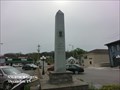
|   Gen. John H. Morgan CSA Monument - Alexandria TN Gen. John H. Morgan CSA Monument - Alexandria TN
in Obelisks The obelisks monument to Gen. John H. Morgan CSA is about 12 feet high and located on West Main Street in Alexandria TN. posted by:  Don.Morfe Don.Morfe location: Tennessee date approved: 05/08/2023 last visited: 05/08/2023 |
 view gallery view galleryNW0 km |  Gen. John H. Morgan CSA Monument - Alexandria TN Gen. John H. Morgan CSA Monument - Alexandria TN
in Specific Veteran Memorials Gen. Morgan left Alexandria on Dec. 21, 1862, with 2,500 horsemen on his Kentucky Christmas Raid. The raid concluded in Smithville Jan. 5, 1863, after the raiders captured 1887 enemy soldiers and destroyed $2,000,000 in Federal property. posted by: Don.Morfe location: Tennessee date approved: 05/09/2023 last visited: 05/09/2023 |
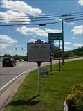
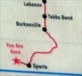 view gallery view galleryNW0 km |  You Are Here Map - Morgan in Alexandria Preparing for a Raid - Alexandria TN You Are Here Map - Morgan in Alexandria Preparing for a Raid - Alexandria TN
in 'You Are Here' Maps The You Are Here Map shows that you are on West Main Street, Dekalb County, Alexandria TN 37012. posted by: Don.Morfe location: Tennessee date approved: 05/05/2023 last visited: 05/06/2023 |
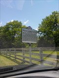
 view gallery view galleryNW0 km |  Morgan in Alexandria-Preparing for a Raid - Alexandria TN Morgan in Alexandria-Preparing for a Raid - Alexandria TN
in Civil War Discovery Trail Sites To disrupt the extended Federal communication and supply lines, late in 1862 Bragg ordered Gen. John Hunt Morgan to attack the Louisville and Nashville Railroad. posted by: Don.Morfe location: Tennessee date approved: 05/08/2020 last visited: 10/08/2021 |
 view gallery view galleryNW0 km | Morgan in Alexandria Preparing for a Raid - Alexandria TN in U.S. Civil War Sites To disrupt the extended Federal communication and supply lines, late in 1862 Gen. Braxton Bragg ordered Gen. John Hunt Morgan to attack the Louisville and Nashville Railroad. Morgan initiated a cavalry raid into Kentucky from here in Alexandria. posted by: Don.Morfe location: Tennessee date approved: 05/06/2023 last visited: 05/06/2023 |
 view gallery view gallery N1.1 km N1.1 km
| Middle Tennessee Veteran's Cemetery in Veteran Cemeteries Middle Tennesse Veteran's Cemetery, located off I-40 on exit 192 (McCrory Lane). posted by: gbworld location: Tennessee date approved: 04/06/2008 last visited: never |
 view gallery view gallery W9 km W9 km
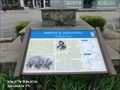
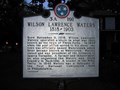
|  Wilson Lawrence Walters - 3 A 191 Wilson Lawrence Walters - 3 A 191
in Tennessee Historical Markers Tennessee Historical Commission marker 3 A 191 - Wilson Lawrence Walters posted by:  LSUMonica LSUMonica location: Tennessee date approved: 03/13/2006 last visited: 02/08/2017 |
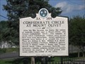 view gallery view galleryN9 km | Confederate Circle at Mount Olivet - 3 A 144 in Tennessee Historical Markers Tennessee Historical Commission marker 3 A 144 - Confederate Circle at Mount Olivet. Located at 1101 Lebanon Pike, Nashville, TN. posted by: LSUMonica location: Tennessee date approved: 04/10/2007 last visited: 04/01/2007 |
 view gallery view gallery S9.2 km S9.2 km
|  N 36° W 86° Tennessee, USA N 36° W 86° Tennessee, USA
in Confluence Spots The confluence spot is located on private property. We gained permission to photograph the area. posted by:  mtn-man mtn-man location: Tennessee date approved: 08/11/2006 last visited: never |
 view gallery view gallery SE12.4 km SE12.4 km
| Battle of Snow Hill - Dowelltown TN in American Civil War Monuments and Memorials Marker is at the intersection of Nashville Highway (U.S. 70) and Old Dry Creek Road, Dowelltown TN 37059 posted by: Don.Morfe location: Tennessee date approved: 10/01/2023 last visited: 10/01/2023 |
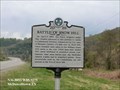
 view gallery view gallerySE12.4 km | Battle of Snow Hill - Dowelltown TN in Tennessee Historical Markers On April 3, 1863, two Union brigades under Gen. Stanley advanced to this position to battle a Confederate Division commanded by Col. Gano of Morgan's Cavalry ½ mile east on Snow Hill. posted by: Don.Morfe location: Tennessee date approved: 05/22/2020 last visited: 10/20/2021 |
 view gallery view gallerySE12.4 km |  Battle of Snow Hill - Dowelltown TN Battle of Snow Hill - Dowelltown TN
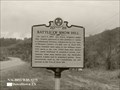
in Battlefields On April 3, 1863, two Union brigades under Gen. Stanley advanced to this position to battle a Confederate Division commanded by Col. Gano of Morgan's Cavalry ½ mile east on Snow Hill. posted by: Don.Morfe location: Tennessee date approved: 11/12/2022 last visited: 11/13/2022 |
 view gallery view gallery NE13.8 km NE13.8 km
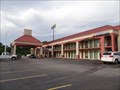
|  Comfort Inn - Free WIFI - Gordonsville, TN Comfort Inn - Free WIFI - Gordonsville, TN
in Wi-Fi Hotspots Comfort Inn - Free WIFI - Gordonsville, TN posted by: walkingwildly location: Tennessee date approved: 06/05/2015 last visited: 06/09/2015 |
 view gallery view galleryNE13.8 km |  Comfort Inn - Dog Friendly Hotel - Gordonsville, TN Comfort Inn - Dog Friendly Hotel - Gordonsville, TN
in Dog Friendly Hotels Comfort Inn - Dog Friendly Hotel - Gordonsville, TN posted by: walkingwildly location: Tennessee date approved: 07/02/2015 last visited: 08/05/2019 |
 view gallery view galleryNE13.8 km |  McD's at I-40, Exit 258 - Gordonsville, TN McD's at I-40, Exit 258 - Gordonsville, TN
in McDonald's Restaurants McD on north side of I-40 Exit 258 is undergoing modernization posted by: vhasler location: Tennessee date approved: 06/17/2012 last visited: 05/31/2015 |
 view gallery view galleryNW18 km | William Haskell Neal 3A 213 in Tennessee Historical Markers Very limited parking on side of road. "Maple Dale Farm was the home of William Haskell Neal. posted by: Team Geologynut location: Tennessee date approved: 05/12/2017 last visited: 01/12/2019 |
 view gallery view gallery E20.1 km E20.1 km
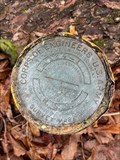
|  US Army COE A124-1 - DeKalb County, TN US Army COE A124-1 - DeKalb County, TN
in U.S. Benchmarks Survey mark at top of ridge at Edgar Evins SP. posted by: TNnomad location: Tennessee date approved: 01/02/2022 last visited: never |
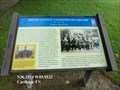
 view gallery view galleryNE20.3 km | Upper Ferry On the Cumberland River - Carthage TN in U.S. Civil War Sites As a major Cumberland River port with three landings, Carthage was strategically important to both Confederate and Union forces. The Upper Ferry and landing was located near the present Corps of Engineer boat ramp near Upper Ferry Road. posted by: Don.Morfe location: Tennessee date approved: 05/08/2023 last visited: 05/08/2023 |
 view gallery view galleryNE20.3 km | Upper Ferry On the Cumberland River - Carthage TN in Civil War Discovery Trail Sites As a major Cumberland River port with three landings, Carthage was strategically important to both Confederate and Union forces. The Upper Ferry and landing was located near the present Corps of Engineer boat ramp near Upper Ferry Road. posted by: Don.Morfe location: Tennessee date approved: 05/09/2020 last visited: 10/08/2021 |
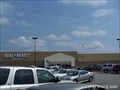 view gallery view galleryNE20.4 km |  Supercenter Wal*Mart - Carthage, TN Supercenter Wal*Mart - Carthage, TN
in WAL*MART Stores Located a short Distance off I-40 at exit 258. posted by: mr.volkswagen location: Tennessee date approved: 09/09/2010 last visited: 08/15/2010 |
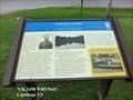
 view gallery view galleryN20.6 km | Cordell Hull Memorial Bridge 3B 83 - Carthage, TN in Tennessee Historical Markers Cordell Hull Memorial Bridge. Good parking across the side street at the Quick & Easy Market. posted by: Team Geologynut location: Tennessee date approved: 01/12/2019 last visited: 04/10/2023 |
 view gallery view galleryN20.6 km |  Smith County Courthouse - Carthage Tennessee Smith County Courthouse - Carthage Tennessee
in Wikipedia Entries The courthouse is located on the Court Square in Carthage, a small town in Smith County, Tennessee, United States. It overlooks the Cumberland River. posted by: Don.Morfe location: Tennessee date approved: 11/09/2022 last visited: 11/10/2022 |
 view gallery view galleryN20.6 km | Smith County Courthouse Square-A Major Federal Base - Carthage TN in U.S. Civil War Sites Carthage’s historic courthouse square was the control center of a major Federal base from 1863 to 1865 in the fight to control the Upper Cumberland River region. posted by: Don.Morfe location: Tennessee date approved: 05/08/2023 last visited: 05/08/2023 |
 view gallery view galleryN20.6 km | Smith County Courthouse Square-A Major Federal Base - Carthage TN in Civil War Discovery Trail Sites Carthage’s historic courthouse square was the control center of a major Federal base from 1863 to 1865 in the fight to control the Upper Cumberland River region. posted by: Don.Morfe location: Tennessee date approved: 05/09/2020 last visited: 10/08/2021 |
 view gallery view galleryN20.6 km |  Smith County Courthouse - Carthage TN Smith County Courthouse - Carthage TN
in Courthouses Carthage’s historic courthouse square was the control center of a major Federal base from 1863 to 1865 in the fight to control the Upper Cumberland River region. posted by: Don.Morfe location: Tennessee date approved: 11/17/2022 last visited: 11/10/2022 |
|