 view gallery view gallery N24.9 km N24.9 km
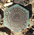
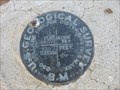
|   USCGS Dayton-Harris Gravity Station Disk: GS0206 USCGS Dayton-Harris Gravity Station Disk: GS0206
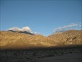
in U.S. Benchmarks This BM is a rare USCGS Gravity Station disk from 1939 recovered in Death Valley, CA. These old gravity disks have the distinct 6 sided design. posted by:  Gungadoy Gungadoy location: California date approved: 04/14/2015 last visited: never |
 view gallery view gallery E25.3 km E25.3 km
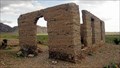
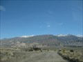
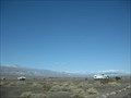
|  Ashford Mills, Death Valley, California Ashford Mills, Death Valley, California
in Ghost Towns From 1914 until 1941, gold ore from the Golden Treasure Mine, five miles to the east was processed in this tiny Death Valley settlement for shipment to a smelter. posted by:  Bernd das Brot Team Bernd das Brot Team location: California date approved: 09/01/2006 last visited: 04/08/2011 |
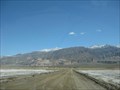
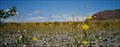 view gallery view galleryE25.3 km |  Ashford Mills Wild Flower Field, Death Valley, California Ashford Mills Wild Flower Field, Death Valley, California
in Flower Fields Amazing display of desert flowers posted by: Bernd das Brot Team location: California date approved: 09/01/2006 last visited: 02/12/2018 |
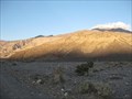 view gallery view gallery NW25.7 km NW25.7 km
|  Surprise Canyon - Ridgecrest, CA Surprise Canyon - Ridgecrest, CA
in Free Campsites A BLM property has several established camping areas along Indian Ranch Rd. posted by: ChapterhouseInc location: California date approved: 02/27/2011 last visited: 02/16/2011 |
 view gallery view galleryNW25.7 km |  Surprise Canyon Wilderness Area - Ridgecrest, CA Surprise Canyon Wilderness Area - Ridgecrest, CA
in Public Access Lands A BLM property serves as a Death Valley National Park addition. posted by: ChapterhouseInc location: California date approved: 02/27/2011 last visited: 02/16/2011 |
 view gallery view gallery W26.7 km W26.7 km
|  Ballarat Ballarat
in Signs of History A small historic marker in this ghost town. posted by: ChapterhouseInc location: California date approved: 02/25/2011 last visited: 02/19/2011 |
 view gallery view galleryW26.7 km | Ballarat, California in Ghost Towns A virtual ghost town serves as a off road base. posted by: ChapterhouseInc location: California date approved: 02/24/2011 last visited: 08/13/2011 |
 view gallery view galleryW26.7 km |  Ballarat, California Ballarat, California
in Wikipedia Entries A virtual ghost town serves as a off road base. posted by: ChapterhouseInc location: California date approved: 02/24/2011 last visited: 03/18/2014 |
 view gallery view galleryW26.9 km |  RV Lot - Ballarat, CA RV Lot - Ballarat, CA
in Free Overnight RV Parking Locations This Ghost Town near Surprise Canyon Wilderness Area has a large lot to accomodate RVs. posted by: ChapterhouseInc location: California date approved: 02/26/2011 last visited: 02/14/2015 |
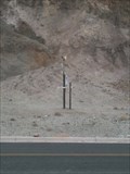
 view gallery view galleryNW29.1 km | GS0341 - 1082 in U.S. Benchmarks A benchmark along Indian Ranch Rd in the BLM Ridgecrest area. posted by: ChapterhouseInc location: California date approved: 02/24/2011 last visited: 02/14/2011 |
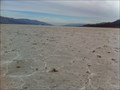
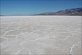 view gallery view galleryN29.9 km |  Lowest Spot In The Western Hemisphere Lowest Spot In The Western Hemisphere
in Places of Geologic Significance 282 feet below sea level. posted by: Neked Treker location: California date approved: 04/23/2008 last visited: 04/07/2022 |
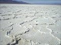 view gallery view galleryN29.9 km |  LOWEST-Point In North America LOWEST-Point In North America
in Superlatives In Badwater Basin in Death Valley National Monument is a spot located 282 feet below sea level. posted by: Six Little Spookies location: California date approved: 06/17/2008 last visited: 04/07/2022 |
 view gallery view gallery NE30.9 km NE30.9 km
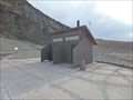
|  Western Hemisphere's Lowest Pit Toilet - Death Valley, CA Western Hemisphere's Lowest Pit Toilet - Death Valley, CA
in Roadside Attractions Pit toilets located at 282 Feet below sea level serving the needs of tourists in the Badwater Basin of Death Valley National Park! posted by: jiggs11 location: California date approved: 04/17/2017 last visited: 10/06/2017 |
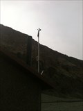 view gallery view galleryNE30.9 km |  Badwater Weather Station - Death Valley National Park, CA Badwater Weather Station - Death Valley National Park, CA
in Weather Stations This is the second lowest weather station in all of North America! posted by: bluesnote location: California date approved: 02/24/2012 last visited: 01/05/2023 |
 view gallery view galleryNE30.9 km |  Badwater Basin - Death Valley Scenic Byway - Death Valley National Park, CA Badwater Basin - Death Valley Scenic Byway - Death Valley National Park, CA
in National Scenic Byways This is the lowest waymark in North America! posted by: bluesnote location: California date approved: 02/22/2012 last visited: 04/07/2022 |
 view gallery view galleryNE30.9 km | Lowest Weather Station in North America in Weather Stations Welcome to the lowest weather station in North America! posted by: bluesnote location: California date approved: 02/24/2012 last visited: 01/05/2023 |
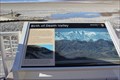 view gallery view galleryNE30.9 km | Birth of Death Valley -- Death Valley National Park, CA in Signs of History One of several interpretive signs at this fascinating area in Death Valley National Park. posted by: Benchmark Blasterz location: California date approved: 03/31/2016 last visited: 04/07/2022 |
 view gallery view galleryNE30.9 km | But It's a Dry Heat -- Death Valley National Park, CA in Signs of History One of several interpretive signs at this fascinating area in Death Valley National Park. posted by: Benchmark Blasterz location: California date approved: 03/31/2016 last visited: 04/07/2022 |
 view gallery view galleryNE30.9 km | Badwater Basin - Death Valley National Park, CA in Wikipedia Entries This is the lowest waymark in North America! posted by: bluesnote location: California date approved: 02/20/2012 last visited: 04/07/2022 |
 view gallery view galleryNE30.9 km |  Badwater - Death Valley National Park, CA Badwater - Death Valley National Park, CA
in Literary Sites In Toni Dwiggins "Badwater", Death Valley earns its name when a terrorist threatens to unleash lethal radioactive toxins -- in America's most fragile national park. posted by: bluesnote location: California date approved: 04/01/2016 last visited: 04/07/2022 |
 view gallery view galleryNE30.9 km |  Badwater Basin - Death Valley National Park, CA Badwater Basin - Death Valley National Park, CA
in Scenic Roadside Look-Outs This is the lowest waymark in North America! posted by: bluesnote location: California date approved: 04/01/2016 last visited: 04/07/2022 |
 view gallery view galleryNE30.9 km |  Badwater Basin - Death Valley National Park, CA Badwater Basin - Death Valley National Park, CA
in Scenic Overlooks This is the lowest waymark in North America! posted by: bluesnote location: California date approved: 04/01/2016 last visited: 04/07/2022 |
 view gallery view galleryNE30.9 km |  Badwater Basin - Death Valley National Park, CA Badwater Basin - Death Valley National Park, CA
in Hiking and walking trailheads This is the lowest waymark in North America! posted by: bluesnote location: California date approved: 04/11/2016 last visited: 04/07/2022 |
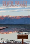 view gallery view galleryNE30.9 km |  Badwater Basin - Death Valley National Park, CA Badwater Basin - Death Valley National Park, CA
in Picture Perfect Postcards This is the lowest waymark in North America! posted by: bluesnote location: California date approved: 04/01/2016 last visited: 04/07/2022 |
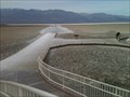 view gallery view galleryNE30.9 km |  Badwater Basin - Death Valley National Park, CA Badwater Basin - Death Valley National Park, CA
in Non-Coastal Boardwalks This is the lowest waymark in North America! posted by: bluesnote location: California date approved: 04/01/2016 last visited: 04/07/2022 |
|