 view gallery view gallery SW1.1 km SW1.1 km
|   West Fork, Arkansas, USA West Fork, Arkansas, USA
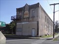
in City and Town Halls This non-descript building, at the corner of Main and Campbell in downtown West Fork, houses all of the City offices, with the exception of the Fire Department. posted by:  Where's George Where's George location: Arkansas date approved: 08/17/2014 last visited: never |
 view gallery view gallerySW1.1 km |  Old Coca-Cola Sign - Little O'Oprey Building - West Fork AR Old Coca-Cola Sign - Little O'Oprey Building - West Fork AR
in Coca Cola Memorabilia This beautiful Coca-Cola sign is painted directly onto the side of the Little O'Oprey building in downtown West Fork. posted by: Where's George location: Arkansas date approved: 08/18/2014 last visited: never |
 view gallery view gallerySW1.1 km |  Little O'Oprey - West Fork AR Little O'Oprey - West Fork AR
in Live Stage Theaters "The Little O’ Oprey was started October 13, 1989, by Dan Weithop. He wanted himself and others to have a place to play music in a venue other than bars or clubs." posted by: Where's George location: Arkansas date approved: 08/21/2014 last visited: never |
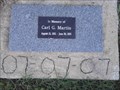 view gallery view gallerySW1.1 km |  Carl G. Martin Memorial Flagpole - West Fork AR Carl G. Martin Memorial Flagpole - West Fork AR
in Citizen Memorials This small plaque, at the base of the church's flagpole, honors a long-time church member. posted by: Where's George location: Arkansas date approved: 08/17/2014 last visited: never |
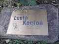 view gallery view gallerySW1.1 km | Leota Keeton Memorial Rose Bush - West Fork AR in Citizen Memorials This wonderful red rose bush, dedicated to the memory of a long-time church member, is planted at the base of the church sign. posted by: Where's George location: Arkansas date approved: 08/18/2014 last visited: never |
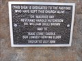 view gallery view gallerySW1.1 km | Memorial Church Sign - West Fork AR in Citizen Memorials This beautiful field-rock church sign is dedicated to 4 previous pastors of this church, who have served over the years. posted by: Where's George location: Arkansas date approved: 08/17/2014 last visited: never |
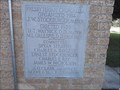 view gallery view gallerySW1.1 km |  1929 - West Fork Presbyterian Church - West Fork AR 1929 - West Fork Presbyterian Church - West Fork AR
in Dated Buildings and Cornerstones Now in its 85th year, this building looks just as great today as it looked "back in the day". posted by: Where's George location: Arkansas date approved: 08/16/2014 last visited: never |
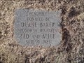 view gallery view gallerySW1.3 km | Ted and Alice Baker Memorial Flagpole - West Fork AR in Citizen Memorials This small memorial plaque rests beneath a flagpole in front of the West Fork Fire Department - Main & McDonald in downtown West Fork. posted by: Where's George location: Arkansas date approved: 08/17/2014 last visited: never |
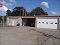 view gallery view gallerySW1.3 km |  West Fork Fire Dep't. West Fork Fire Dep't.
in Firehouses "The City's Fire Department is centrally located and works collaboratively with local rural volunteer fire services." posted by: Where's George location: Arkansas date approved: 08/25/2014 last visited: never |
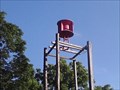 view gallery view gallerySW1.3 km |  West Fork Storm Warning Siren - West Fork AR West Fork Storm Warning Siren - West Fork AR
in Outdoor Warning Sirens This siren is located behind the West Fork Fire Department - Main @ McDonald in downtown West Fork. posted by: Where's George location: Arkansas date approved: 08/27/2014 last visited: never |
 view gallery view gallery S5.3 km S5.3 km
|  Woolsey Bridge Woolsey Bridge
in Truss Bridges A two-span through truss bridge over West Fork White River posted by:  cache_me_in cache_me_in location: Arkansas date approved: 12/17/2007 last visited: never |
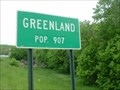 view gallery view gallery N5.6 km N5.6 km
|  GREENLAND Arkansas / USA GREENLAND Arkansas / USA
in Population Signs Greenland Arkansas Population 907+ posted by: GEO*Trailblazer 1 location: Arkansas date approved: 12/12/2007 last visited: 03/14/2008 |
 view gallery view galleryN8 km |  Greenland, AR. 72737 Greenland, AR. 72737
in U.S. Post Offices Post office in Greenland, AR posted by: bhr1630 location: Arkansas date approved: 03/14/2008 last visited: never |
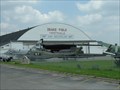
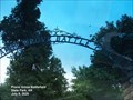
 view gallery view galleryN8.4 km |  Arkansas Air Museum Arkansas Air Museum
in Aviation Museums Follow the colorful history of aviation in Arkansas through numerous displays of original artifacts and aviation memorabilia posted by: Where's George location: Arkansas date approved: 10/18/2011 last visited: 08/18/2012 |
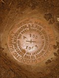 view gallery view galleryN8.4 km |  USGS A 155 - 1963, Drake Field - Fayetteville, AR USGS A 155 - 1963, Drake Field - Fayetteville, AR
in U.S. Benchmarks U.S. Geological Survey Benchmark Disk A 155, located at the Drake Field Municipal Airport in Fayetteville, AR located directly beneath the airport beacon (GG0643). posted by: RazorbackFan location: Arkansas date approved: 12/27/2007 last visited: 02/28/2013 |
 view gallery view galleryN8.4 km |  Drake Field - Fayetteville, AR Drake Field - Fayetteville, AR
in Airports Drake Field Fayetteville, Arkansas Airport and Museum posted by: GEO*Trailblazer 1 location: Arkansas date approved: 12/30/2006 last visited: 03/14/2008 |
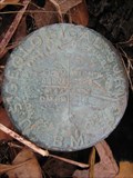 view gallery view gallery NW9.2 km NW9.2 km
| USGS 1146 - Illinois Chapel, Prairie Grove, AR in U.S. Benchmarks U.S. Geological Survey Benchmark Disk located at the Illinois Chapel Baptist Church near Prarie Grove, AR. posted by: RazorbackFan location: Arkansas date approved: 12/30/2008 last visited: 06/27/2009 |
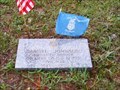 view gallery view gallerySW12.1 km |  Samuel Johnson-Onda, AR Samuel Johnson-Onda, AR
in Medal Of Honor Resting Places Civil War Medal of Honor Recipient for action at Antietam, MD on September 17, 1862. He is buried in Baker Cemetery, Onda, AR. posted by: Don.Morfe location: Arkansas date approved: 10/17/2018 last visited: 12/08/2021 |
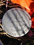 view gallery view galleryN12.6 km | AR Geological Commission - PLS 1514, Fayetteville, AR in U.S. Benchmarks Arkansas Geological Commission, Land Survey Division, Cadastral Mark (PLS 1514), located in NE corner of Combs Cemetery, near the intersection of Pump Station Road and Leeper Drive in Fayetteville, AR. posted by: RazorbackFan location: Arkansas date approved: 12/30/2007 last visited: 03/11/2008 |
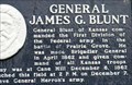 view gallery view galleryNW12.9 km |  General James G. Blunt - Prairie Grove AR General James G. Blunt - Prairie Grove AR
in U.S. Civil War Sites General Blunt of Kansas commanded the First Division of the Federal army in the battle of Prairie Grove. He was made Brigadier General in April 1862 and given command of all Kansas troops. posted by: Don.Morfe location: Arkansas date approved: 11/07/2020 last visited: 09/30/2021 |
 view gallery view galleryNW12.9 km |  General James G. Blunt - Prairie Grove AR General James G. Blunt - Prairie Grove AR
in Arkansas Historical Markers General Blunt of Kansas commanded the First Division of the Federal army in the battle of Prairie Grove. He was made Brigadier General in April 1862 and given command of all Kansas troops. posted by: Don.Morfe location: Arkansas date approved: 10/07/2022 last visited: 09/11/2022 |
 view gallery view galleryNW12.9 km | Prairie Grove Battlefield State Park - Prairie Grove, Arkansas in Civil War Discovery Trail Sites A major battle on December 7, 1862, causing the withdrawl of Confederate forces from Northwestern Arkansas. posted by: gparkes location: Arkansas date approved: 11/21/2009 last visited: 09/11/2022 |
 view gallery view galleryNW12.9 km |  Prairie Grove Battlefield State Park - Prairie Grove AR Prairie Grove Battlefield State Park - Prairie Grove AR
in State/Provincial Parks Recognized nationally as one of America’s most intact Civil War battlefields, Prairie Grove Battlefield State Park protects the battle site and interprets the Battle of Prairie Grove, which occurred on December 7, 1862. posted by: Don.Morfe location: Arkansas date approved: 09/11/2022 last visited: 09/11/2022 |
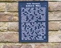 view gallery view galleryNW12.9 km |  Rhea's Mill Battle Monument - Prairie Grove AR Rhea's Mill Battle Monument - Prairie Grove AR
in Signs of History This tower was the chimney of Rhea's Mill, which stood 6 miles northwest of this spot. The mill was operated by the Federal army before and after the battle of Prairie Grove. posted by: Don.Morfe location: Arkansas date approved: 09/08/2023 last visited: 09/08/2023 |
 view gallery view galleryNW12.9 km |  Prairie Grove Battlefield - Prairie Grove, Arkansas Prairie Grove Battlefield - Prairie Grove, Arkansas
in Battlefields A major battle on December 7, 1862, causing the withdrawl of Confederate forces from Northwestern Arkansas. posted by: gparkes location: Arkansas date approved: 11/21/2009 last visited: 09/11/2022 |
|