 view gallery view gallery SW7.4 km SW7.4 km
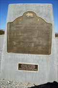
|   #622 - Harry Wade Exit Route #622 - Harry Wade Exit Route
in California Historical Markers This marker notes the approximate spot where Harry Wade and his family found the Spanish Trail after leaving a larger party in Death Valley, in 1849. posted by:  chaosmanor chaosmanor location: California date approved: 08/18/2011 last visited: 05/25/2018 |
 view gallery view gallery W17.1 km W17.1 km
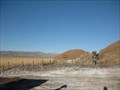
|  Saratoga Springs - Death Valley, CA Saratoga Springs - Death Valley, CA
in Natural Springs One of several unique features found in Death Valley National Park. 4x4 might be required. A trail loops around the area. posted by: ChapterhouseInc location: California date approved: 01/27/2011 last visited: 01/22/2011 |
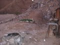
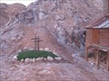 view gallery view galleryW18.8 km |  Cabin Cemetery - CA Cabin Cemetery - CA
in Worldwide Cemeteries A pair of graves lies next to the two friends 'hunting' cabin in the desert. posted by: ChapterhouseInc location: California date approved: 01/27/2011 last visited: 01/19/2011 |
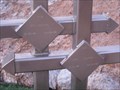 view gallery view galleryW18.8 km |  Cabin Cemetery Headstones - CA Cabin Cemetery Headstones - CA
in Homemade Tombstones A pair of graves lies next to the two friends 'hunting' cabin in the desert. posted by: ChapterhouseInc location: California date approved: 01/27/2011 last visited: 01/19/2011 |
 view gallery view galleryW18.8 km |  Cabin Cemetery - CA Cabin Cemetery - CA
in Out of Place Graves A pair of graves lies next to the two friends 'hunting' cabin in the desert. posted by: ChapterhouseInc location: California date approved: 01/26/2011 last visited: 01/19/2011 |
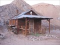 view gallery view galleryW18.8 km |  Hollow Hills Cabin - CA Hollow Hills Cabin - CA
in Best Kept Secrets Located in the BLM Hollow Hills Wilderness Area, this cabin has been a recreational hideaway to many people since 1927. posted by: ChapterhouseInc location: California date approved: 02/09/2011 last visited: 01/18/2011 |
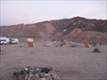 view gallery view galleryW18.8 km |  Cabin Campsite - Hollow Hills, CA Cabin Campsite - Hollow Hills, CA
in Free Campsites Located in the Hollow Hills Recreation Area, a cabin sits at a longtime camping area. posted by: ChapterhouseInc location: California date approved: 01/27/2011 last visited: 01/19/2011 |
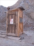 view gallery view galleryW18.8 km |  Cabin Outhouse - Hollow Hills, CA Cabin Outhouse - Hollow Hills, CA
in Outhouses A functional outhouse serves a remote cabin on BLM property. posted by: ChapterhouseInc location: California date approved: 01/26/2011 last visited: 01/19/2011 |
 view gallery view gallery N18.8 km N18.8 km
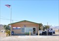
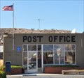
|  Tecopa, California 92389 Tecopa, California 92389
in U.S. Post Offices This Post Office is located at 101 Old Spanish Trail Highway in Tecopa, California. posted by: brwhiz location: California date approved: 01/08/2012 last visited: never |
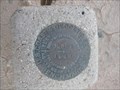 view gallery view galleryW20.6 km |  FT0152 - P684 FT0152 - P684
in U.S. Benchmarks Located in Death Valley National Park along a dirt road. posted by: ChapterhouseInc location: California date approved: 01/30/2011 last visited: 01/19/2011 |
 view gallery view gallerySW23.5 km |  Hollow Hills Wilderness Area - BLM - CA Hollow Hills Wilderness Area - BLM - CA
in Public Access Lands A large wilderness provices ample recreational opportunities. posted by: ChapterhouseInc location: California date approved: 01/27/2011 last visited: 01/18/2011 |
 view gallery view gallery NW32.7 km NW32.7 km
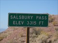
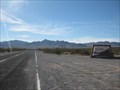
|  Salsbury Pass, CA - 3315 feet Salsbury Pass, CA - 3315 feet
in Elevation Signs This sign is located on a lonely road, heading west, between Shoshone and Badwater. Be sure and look for the nearby geocache - GC10JJF salsbury pass cache. posted by: Free2bme29 location: California date approved: 10/14/2009 last visited: 09/14/2021 |
 view gallery view galleryN33.2 km | Shoshone, California 92384 in U.S. Post Offices This Post Office is located at 113 N State Highway 127 in Shoshone, California. posted by: brwhiz location: California date approved: 01/08/2012 last visited: 02/11/2012 |
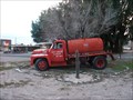 view gallery view galleryN33.2 km |  Tecopa - Shoshone, CA Vol. Fire Departmet truck Tecopa - Shoshone, CA Vol. Fire Departmet truck
in Fire Fighting Vehicles Fire truck to greet you as you enter Shoshone, CA from the north side of town. posted by: DJKing location: California date approved: 01/23/2011 last visited: never |
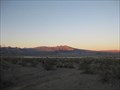
 view gallery view galleryN34.9 km |  Death Valley National Park Death Valley National Park
in Wikipedia Entries The largest park in the lower 48 states has many unique features to explore. This mark is at one of the southern border crossings. posted by: ChapterhouseInc location: California date approved: 01/17/2011 last visited: 03/03/2022 |
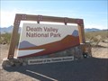 view gallery view galleryN34.9 km |  Death Valley National Park Death Valley National Park
in National Parks of the World The largest park in the lower 48 states has many unique features to explore. This mark is at one of the southern border crossings. posted by: ChapterhouseInc location: California date approved: 01/20/2011 last visited: 08/03/2020 |
 view gallery view gallery NE41.4 km NE41.4 km
|  36N x 116W Confluence Near Pahrump, NV 36N x 116W Confluence Near Pahrump, NV
in Confluence Spots Confluence visited in May 16th, 2003 posted by: W7MAG location: California date approved: 09/12/2009 last visited: 08/05/2011 |
 view gallery view gallery SE45.1 km SE45.1 km
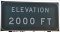
| Halloran Springs, South Grade ~ Interstate 15 Southbound - Elevation 2000 feet in Elevation Signs Descending through 2000 feet on your way into Baker. posted by: brwhiz location: California date approved: 03/15/2012 last visited: 03/08/2016 |
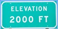 view gallery view gallerySE45.2 km | Halloran Springs, South Grade ~ Interstate 15 Northbound - Elevation 2000 feet in Elevation Signs The 2000 foot level as you climb out of Baker toward Halloran Springs. posted by: brwhiz location: California date approved: 03/18/2011 last visited: 03/30/2012 |
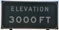 view gallery view gallerySE45.9 km | Halloran Springs ~ Interstate 15 Southbound - Elevation 3000 feet in Elevation Signs Descending through 3000 feet as you pass through the Halloran Springs interchange and continue your descent into Baker. posted by: brwhiz location: California date approved: 03/15/2012 last visited: 03/08/2016 |
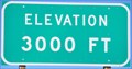 view gallery view gallerySE45.9 km | Halloran Springs ~ Interstate 15 Northbound - Elevation 3000 feet in Elevation Signs The 3000 foot level as you climb out of Baker and reach Halloran Springs. posted by: brwhiz location: California date approved: 03/18/2011 last visited: 03/30/2012 |
 view gallery view gallery S47 km S47 km
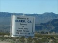
|  Baker, CA - Gateway to Death Valley Baker, CA - Gateway to Death Valley
in Welcome Signs Baker, CA - Gateway to Death Valley posted by: JacobBarlow location: California date approved: 12/30/2007 last visited: 03/08/2016 |
 view gallery view galleryS47.3 km | Baker, California 92309 in U.S. Post Offices Baker, California's Post Office. posted by: JacobBarlow location: California date approved: 12/28/2007 last visited: 05/06/2018 |
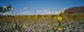 view gallery view galleryNW47.5 km |  Ashford Mills Wild Flower Field, Death Valley, California Ashford Mills Wild Flower Field, Death Valley, California
in Flower Fields Amazing display of desert flowers posted by:  Bernd das Brot Team Bernd das Brot Team location: California date approved: 09/01/2006 last visited: 02/12/2018 |
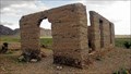 view gallery view galleryNW47.5 km |  Ashford Mills, Death Valley, California Ashford Mills, Death Valley, California
in Ghost Towns From 1914 until 1941, gold ore from the Golden Treasure Mine, five miles to the east was processed in this tiny Death Valley settlement for shipment to a smelter. posted by: Bernd das Brot Team location: California date approved: 09/01/2006 last visited: 04/08/2011 |
|