 view gallery view gallery NW1.3 km NW1.3 km
|   Cataloochee Ski Area - Maggie Valley, NC Cataloochee Ski Area - Maggie Valley, NC
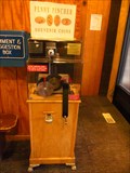
in Penny Smashers This penny smasher is located at Cataloochee Ski Area 1080 Ski Lodge Road, Maggie Valley, North Carolina. posted by:  DougandSandra DougandSandra location: North Carolina date approved: 03/12/2013 last visited: never |
 view gallery view gallery SW2.7 km SW2.7 km
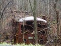
|  Rusted Bus - Maggie Valley, North Carolina Rusted Bus - Maggie Valley, North Carolina
in Abandoned Dead Vehicles This old bus is located on Fie Top Rd., in Maggie Valley, NC posted by: DougandSandra location: North Carolina date approved: 10/19/2013 last visited: 05/27/2017 |
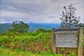
 view gallery view gallery N3.9 km N3.9 km
|  Purchase Knob Purchase Knob
in Web Cameras Located at 5000 feet on the North Carolina side of Great Smoky Mountains National Park, the Appalachian Highlands Science Learning Center at Purchase Knob is part of a network of what will be 32 learning centers supporting research and education in our national parks. posted by: OzGuff location: North Carolina date approved: 08/27/2005 last visited: 01/12/2018 |
 view gallery view gallery S4 km S4 km
|  Fantasy Golf at Maggie Valley, NC Fantasy Golf at Maggie Valley, NC
in Miniature Golf Waterfalls, lighthouse, caves, boat, tunnels await you and your putter! posted by: TheGeoGnomes location: North Carolina date approved: 08/08/2010 last visited: 09/30/2020 |
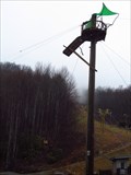
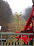 view gallery view gallerySW4.2 km |  Ghost Town in the Sky Chairlift - Maggie Valley, North Carolina Ghost Town in the Sky Chairlift - Maggie Valley, North Carolina
in Aerial Lifts This lift is located at Ghost Town in the Sky amusement park, off U.S. Highway 19, at 16 Fie Top Rd in Maggie Valley, North Carolina posted by: DougandSandra location: North Carolina date approved: 04/09/2013 last visited: 09/30/2020 |
 view gallery view gallerySW4.2 km |  Ghost Town Zip Lines - Maggie Valley, North Carolina Ghost Town Zip Lines - Maggie Valley, North Carolina
in Zip-line Ghost Town Zip Lines are located off U.S. Highway 19, at 16 Fie Top Rd in Maggie Valley, North Carolina posted by: DougandSandra location: North Carolina date approved: 04/09/2013 last visited: 09/30/2020 |
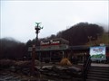 view gallery view gallerySW4.2 km |  Ghost Town in the Sky - Maggie Valley, North Carolina Ghost Town in the Sky - Maggie Valley, North Carolina
in Roadside Attractions Ghost Town in the Sky is a Wild West-themed amusement park. The park's entrance is located off U.S. Highway 19, at 16 Fie Top Rd in Maggie Valley, North Carolina posted by: DougandSandra location: North Carolina date approved: 04/10/2013 last visited: 09/30/2020 |
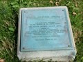
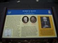 view gallery view gallerySW4.2 km |  Kirk's Raid Unwanted Intruders - Maggie Valley in Haywood County, North Carolina Kirk's Raid Unwanted Intruders - Maggie Valley in Haywood County, North Carolina
in Civil War Discovery Trail Sites Marker is in Maggie Valley, North Carolina, in Haywood County. Marker is on Soco Road (North Carolina Route 19) posted by:  Countrydragon Countrydragon location: North Carolina date approved: 01/01/2010 last visited: 09/30/2020 |
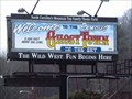 view gallery view gallerySW4.2 km | Ghost Town in the Sky - Maggie Valley, North Carolina in Amusement Parks Ghost Town in the Sky is a Wild West-themed amusement park. The park's entrance is located off U.S. Highway 19, at 16 Fie Top Rd in Maggie Valley, North Carolina posted by: DougandSandra location: North Carolina date approved: 04/08/2013 last visited: 09/30/2020 |
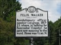 view gallery view galleryS4.7 km |  Felix Walker (P26) Felix Walker (P26)
in North Carolina Historical Markers Revolutionary officer,
member Congress, 1817 posted by: TheGeoGnomes location: North Carolina date approved: 08/09/2010 last visited: 09/30/2020 |
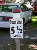 view gallery view gallery NE7.4 km NE7.4 km
|  5 1/2 MPH, Pride RV Resort, Maggie Valley, NC 5 1/2 MPH, Pride RV Resort, Maggie Valley, NC
in Unusual Speed Limits 5 1/2 MPH speed limit at Pride RV Resort outside Maggie Valley, NC posted by: tyro-n-www location: North Carolina date approved: 06/24/2013 last visited: never |
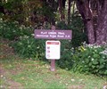
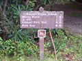 view gallery view galleryNW7.7 km |  Rough Fork Trail - Great Smoky Mountains National Park, TN Rough Fork Trail - Great Smoky Mountains National Park, TN
in Hiking and walking trailheads Cataloochee Valley trailhead of the Rough Fork Trail. posted by: hummerstation location: Tennessee date approved: 09/11/2012 last visited: never |
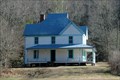 view gallery view galleryN8 km |  Caldwell House Caldwell House
in Homesteads The Hiram Caldwell home of the Cataloochee valley is an early 1900's home, finished in 1906. Build as a modern framed structure with weatherboarding and interior paneling. This home was modern, stylish and very comfortable for its time. posted by: OshnDoc location: North Carolina date approved: 09/21/2011 last visited: 06/22/2015 |
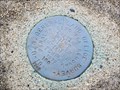
 view gallery view gallery W8.2 km W8.2 km
|  NPS Marker along the Blue Ridge Parkway NPS Marker along the Blue Ridge Parkway
in U.S. Benchmarks A NPS marker along the Blue Ridge Parkway near the Masonic marker. posted by: Manville Possum location: North Carolina date approved: 09/26/2011 last visited: 09/30/2020 |
 view gallery view galleryN8.5 km | Cataloochee School House in Homesteads An old abandoned historical school house in the beautiful Cataloochee valley. Part of the local group of houses in the area. posted by: OshnDoc location: North Carolina date approved: 09/06/2011 last visited: 06/22/2015 |
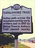 view gallery view galleryNE8.7 km | "Cataloochee Trail"-P 51 in North Carolina Historical Markers On US 276 near I-40. posted by: Markerman62 location: North Carolina date approved: 03/11/2015 last visited: 03/27/2015 |
 view gallery view galleryW9 km | Flat Creek Trail (North End) - Great Smoky Mountains National Park, TN in Hiking and walking trailheads The Flat Creek Trail is a 2.6 mile trail running from the Balsam Mountain Picnic Area to Heintooga Ridge Road. posted by: hummerstation location: Tennessee date approved: 03/20/2016 last visited: never |
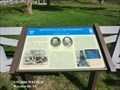
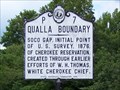 view gallery view gallerySW9.2 km | P7 Qualla Boundary - Maggie Valley, NC in North Carolina Historical Markers Historical marker at the starting point of survey that created the Qualla Boundary, the official name for the Cherokee Indian Reservation in western North Carloina. posted by: hummerstation location: North Carolina date approved: 09/07/2012 last visited: 11/28/2022 |
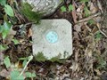
 view gallery view gallerySW9.2 km | Initial Point Qualla Indian Boundary Survey - Maggie Valley, NC in U.S. Benchmarks Disk marking the initial point of the survey establishing the Qualla Boundary. posted by: hummerstation location: North Carolina date approved: 09/06/2012 last visited: 11/28/2022 |
 view gallery view gallerySW9.2 km |  Initial Point Qualla Indian Boundary Survey - Maggie Valley, NC Initial Point Qualla Indian Boundary Survey - Maggie Valley, NC
in U.S. Historic Survey Stones and Monuments Disk marking the initial point of the survey establishing The Qualla Boundary. posted by: hummerstation location: North Carolina date approved: 09/08/2012 last visited: 11/28/2022 |
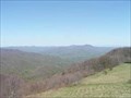
 view gallery view gallerySW9.7 km |  Plott Balsam - Blue Ridge Parkway - Maggie Valley NC Plott Balsam - Blue Ridge Parkway - Maggie Valley NC
in Scenic Roadside Look-Outs Turnout with marker for some info on the Plott Balsams Mountain range on the Blue Ridge Parkway. posted by: nomadwillie location: North Carolina date approved: 11/08/2013 last visited: 06/10/2018 |
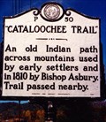 view gallery view gallery E9.8 km E9.8 km
| "Cataloochee Trail"-P 50 in North Carolina Historical Markers A marker across from Lake Junaluska. posted by: Markerman62 location: North Carolina date approved: 03/11/2015 last visited: 06/06/2018 |
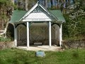 view gallery view gallery SE10.3 km SE10.3 km
|  Sulphur Springs Park Gazebo - Waynesville NC Sulphur Springs Park Gazebo - Waynesville NC
in Gazebos The park contains a small gazebo and small open green space. This park is roughly 1 acre. posted by: Don.Morfe location: North Carolina date approved: 04/29/2023 last visited: 04/29/2023 |
 view gallery view gallerySE10.3 km |  White Sulphur Springs - Waynesville NC White Sulphur Springs - Waynesville NC
in Signs of History Last remaining structure on the grounds of the famous resort, The White Sulphur Springs Hotel owned by Col and Mrs. W.W. Stringfield posted by: Don.Morfe location: North Carolina date approved: 05/06/2023 last visited: 05/07/2023 |
 view gallery view gallerySE10.3 km |  Waynesville Engagement - Waynesville NC Waynesville Engagement - Waynesville NC
in Battlefields On May 6, 1865 a company of Confederate Col. William H. Thomas’s Legion under Lt. Robert T. Conley defeated a company of Bartlett’s mounted infantry at White Sulphur Springs. posted by: Don.Morfe location: North Carolina date approved: 04/29/2023 last visited: 04/30/2023 |
|