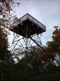
 view gallery view gallery NW6 km NW6 km
|   Wesser Bald Tower Wesser Bald Tower
in Look-Out Towers Classic steel and wood observation deck. posted by:  ar_kayaker ar_kayaker location: North Carolina date approved: 09/02/2008 last visited: never |
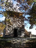 view gallery view gallery S6.8 km S6.8 km
| Wayah Bald Tower (John B. Bryne Tower) Near Franklin, North Carolina in Look-Out Towers Located in the Nantahala National Forest. posted by: david28377 location: North Carolina date approved: 10/25/2013 last visited: 07/08/2023 |
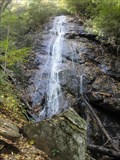 view gallery view galleryS10.5 km |  Rufus Morgan Falls - Near Franklin, North Carolina Rufus Morgan Falls - Near Franklin, North Carolina
in Waterfalls A 60 foot waterfall located in the Nantahala National Forest west of Franklin, North Carolina. posted by: david28377 location: North Carolina date approved: 10/22/2013 last visited: 10/20/2013 |
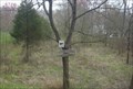 view gallery view gallery E11.1 km E11.1 km
|  Little Tennessee River - Macon County, NC Little Tennessee River - Macon County, NC
in High Level Marks The Land Trust for the Little Tennessee marks the high water flood level as of September 17, 2004. posted by:  cldisme cldisme location: North Carolina date approved: 04/14/2009 last visited: never |
 view gallery view galleryE11.1 km |  Cowee (Q-39) - Cowee, NC Cowee (Q-39) - Cowee, NC
in North Carolina Historical Markers A brief history of the Cowee village, now lost. posted by: cldisme location: North Carolina date approved: 04/15/2009 last visited: 09/13/2001 |
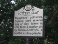 view gallery view galleryE11.6 km | Pottery Clay Q36 - Cowee, NC in North Carolina Historical Markers Local white clay was used to make early Wedgewood china in England posted by: vhasler location: North Carolina date approved: 07/19/2010 last visited: 09/13/2001 |
 view gallery view galleryE11.7 km |  Cowee--West's Mill Historic District, NC Cowee--West's Mill Historic District, NC
in U.S. National Register of Historic Places This NRHP registration covers the historical Cherokee village of Cowee and the 20th century town of West's Mill. posted by: vhasler location: North Carolina date approved: 07/16/2010 last visited: never |
 view gallery view galleryE11.7 km |  Aunt Vonnie West House/County Home Co-op (1936) - Cowee, NC Aunt Vonnie West House/County Home Co-op (1936) - Cowee, NC
in NRHP Historic Districts - Contributing Buildings Former home of s schoolteacher who taught for 50 years posted by: vhasler location: North Carolina date approved: 07/17/2010 last visited: never |
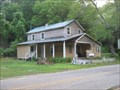
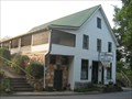 view gallery view galleryE11.7 km | T.R. Rickman Store - Cowee, NC in NRHP Historic Districts - Contributing Buildings The general goods store, built in 1895, is still in operation in the historical community. posted by: vhasler location: North Carolina date approved: 07/17/2010 last visited: never |
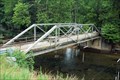
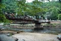 view gallery view galleryNW11.7 km |  Founder's Bridge, Wesser NC Founder's Bridge, Wesser NC
in Truss Bridges Located directly off of highway 74 posted by: CoinsAndPins location: North Carolina date approved: 08/29/2007 last visited: 08/13/2020 |
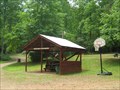 view gallery view galleryE11.7 km |  Rose Creek Campground & Cabins - Frankin, NC Rose Creek Campground & Cabins - Frankin, NC
in Campgrounds Small clean & neat campground north of Franklin, NC posted by: vhasler location: North Carolina date approved: 09/01/2010 last visited: never |
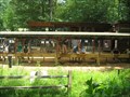 view gallery view galleryE11.7 km |  Rose Creek Mine - Franklin, NC Rose Creek Mine - Franklin, NC
in Rock-Hounding Small sluice to screen out the clay from your own bucket of gems posted by: vhasler location: North Carolina date approved: 07/18/2010 last visited: never |
 view gallery view galleryNW11.9 km |  NC-1180 Bridge NC-1180 Bridge
in Orphaned Bridges Located right off of highway 74 posted by: CoinsAndPins location: North Carolina date approved: 08/26/2007 last visited: 06/22/2009 |
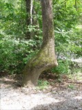 view gallery view galleryNW11.9 km |  Cherokee Trail Tree, Wesner, North Carolina Cherokee Trail Tree, Wesner, North Carolina
in Native American Trail Trees Trail tree pointing directly at the confluence of the Nantahala River and Wesser Creek. posted by: PersonsMD location: North Carolina date approved: 09/13/2009 last visited: 08/22/2012 |
 view gallery view galleryNW11.9 km |  "Raftie, Raftie," Wesser, North Carolina "Raftie, Raftie," Wesser, North Carolina
in Photo Cutouts A fun lifelike cut out at a water rafting pull out on the Great Smokey Mountain Rail Road. posted by: PersonsMD location: North Carolina date approved: 09/14/2009 last visited: 09/12/2009 |
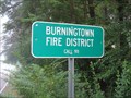 view gallery view galleryE11.9 km |  Burningtown Fire District - Call 911 Burningtown Fire District - Call 911
in Unintentionally Funny Signs Would it be considered a prank call, if you told 911 that you were in a Burningtown? posted by: vhasler location: North Carolina date approved: 07/26/2010 last visited: never |
 view gallery view galleryE12.4 km |  Flowered Cross - Cowee, NC Flowered Cross - Cowee, NC
in Painted Barn Quilts On the front of the historical Pleasant Hill AME Church posted by: vhasler location: North Carolina date approved: 07/14/2010 last visited: never |
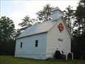 view gallery view galleryE12.4 km | Pleasant Hill AME Church - Cowee, NC in NRHP Historic Districts - Contributing Buildings Small white clapboard church built in 1929 for free blacks and slaves posted by: vhasler location: North Carolina date approved: 07/17/2010 last visited: never |
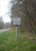
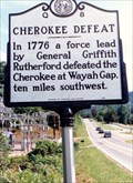 view gallery view galleryE12.6 km | Cherokee Defeat-Q 8 in North Carolina Historical Markers Another marker near Franklin that depicts Cherokee action in the area. posted by: Markerman62 location: North Carolina date approved: 03/11/2015 last visited: 03/27/2015 |
 view gallery view galleryE12.6 km |  30/34 - Franklin, NC - USA 30/34 - Franklin, NC - USA
in Cycling Routes Intersection of North Carolina cycling routes 30 and 34 is north of Franklin along Highway NC28 posted by: vhasler location: North Carolina date approved: 07/16/2010 last visited: never |
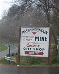 view gallery view galleryE12.6 km | Mason Mountian Mine - Franklin, NC in Rock-Hounding Mason Mountain Mine offers many different opportunities to find gems. posted by: cldisme location: North Carolina date approved: 04/15/2009 last visited: 08/14/2009 |
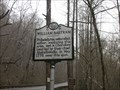
 view gallery view gallery W14.2 km W14.2 km
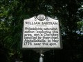
| WILLIAM BARTRAM ~ Q 44 in North Carolina Historical Markers This marker is located on Hwy. 74 at the Patton's Run pull off in the Nantahala Gorge. posted by: BackBrakeBilly location: North Carolina date approved: 09/11/2007 last visited: 08/30/2022 |
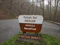 view gallery view galleryW14.2 km |  Patton's Run Overlook; Nantahala National Forest - Macon Co., NC Patton's Run Overlook; Nantahala National Forest - Macon Co., NC
in Scenic Roadside Look-Outs Patton's Run Overlook provides travelers a glimpse of the Nantahala River, plus it doubles as an emergency landing for whitewater and kayaking enthusiasts. posted by: cldisme location: North Carolina date approved: 06/13/2009 last visited: 09/28/2015 |
 view gallery view galleryW14.2 km |  William Bartram - Macon County, NC William Bartram - Macon County, NC
in Bartram Trail Historical Markers Within the Nantahala Gorge, Bartram notes his meeting with Cherokee chief Atakullakulla. posted by: cldisme location: North Carolina date approved: 04/13/2009 last visited: 08/30/2022 |
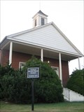 view gallery view gallery SE15 km SE15 km
| Franklin Presbyterian Church - Franklin, NC in U.S. National Register of Historic Places Original sanctuary of the now First Presbyterian Church was built in 1854. posted by: vhasler location: North Carolina date approved: 07/15/2010 last visited: never |
|