  SW3.5 km SW3.5 km
|   Jesus at Jacobs Well - Valleytown Cemetery - Andrews, NC - USA Jesus at Jacobs Well - Valleytown Cemetery - Andrews, NC - USA
in Statues of Religious Figures Two white marble statues depicting Jesus at Jacobs Well with the Samaritan woman as referenced in the KJV Bible book of John. posted by:  [DELETED_USER] [DELETED_USER] location: North Carolina date approved: 03/02/2021 last visited: never |
 view gallery view gallery W4 km W4 km
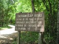
|  Tatham Gap Rd. Part of the Trail of Tears Tatham Gap Rd. Part of the Trail of Tears
in Trail of Tears Sign showing the end of the Tatham Gap Rd. posted by:  paul-3 paul-3 location: North Carolina date approved: 05/05/2012 last visited: never |
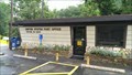
 view gallery view galleryW4.7 km |  Post 7620 - Andrews, NC Post 7620 - Andrews, NC
in VFW Posts VFW Post 7620 is located in Andrews, NC. posted by: lilluckyclover location: North Carolina date approved: 09/21/2007 last visited: 09/13/2007 |
 view gallery view gallery NW5.6 km NW5.6 km
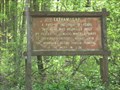
| Tatham Gap Rd-highest point. Part of Trail of Tears. in Trail of Tears High point of Tatham Gap Rd. El: 3645' posted by: paul-3 location: North Carolina date approved: 05/05/2012 last visited: never |
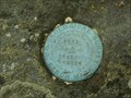 view gallery view galleryNW5.6 km |  Tatham Gap USGS Benchmark Tatham Gap USGS Benchmark
in U.S. Benchmarks Elevation BM on the Tatham Gap Road between Andrews and Robbinsville, NC. posted by: paul-3 location: North Carolina date approved: 05/05/2012 last visited: never |
 view gallery view gallery NE7.1 km NE7.1 km
|  Topton, NC Post Office - 28781 Topton, NC Post Office - 28781
in U.S. Post Offices The Post Office is located at 23979 U.S. 19, Topton, NC 28781. The phone number is (828) 321-5301. posted by: DukeRoom location: North Carolina date approved: 08/15/2013 last visited: 10/12/2014 |
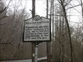 view gallery view galleryNE11.1 km |  William Bartram - Macon County, NC William Bartram - Macon County, NC
in Bartram Trail Historical Markers Within the Nantahala Gorge, Bartram notes his meeting with Cherokee chief Atakullakulla. posted by: cldisme location: North Carolina date approved: 04/13/2009 last visited: 08/30/2022 |
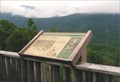
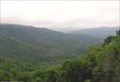
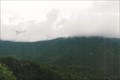
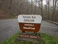 view gallery view galleryNE11.1 km |  Patton's Run Overlook; Nantahala National Forest - Macon Co., NC Patton's Run Overlook; Nantahala National Forest - Macon Co., NC
in Scenic Roadside Look-Outs Patton's Run Overlook provides travelers a glimpse of the Nantahala River, plus it doubles as an emergency landing for whitewater and kayaking enthusiasts. posted by: cldisme location: North Carolina date approved: 06/13/2009 last visited: 09/28/2015 |
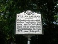 view gallery view galleryNE11.1 km |  WILLIAM BARTRAM ~ Q 44 WILLIAM BARTRAM ~ Q 44
in North Carolina Historical Markers This marker is located on Hwy. 74 at the Patton's Run pull off in the Nantahala Gorge. posted by: BackBrakeBilly location: North Carolina date approved: 09/11/2007 last visited: 08/30/2022 |
 view gallery view gallery N12.4 km N12.4 km
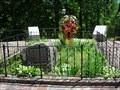
| Junaluska and Nicie Gravesite - Robbinsville, NC in Trail of Tears Junaluska Museum is located on Junaluska Rd in Robbinsville, NC posted by: nomadwillie location: North Carolina date approved: 05/17/2011 last visited: 05/22/2008 |
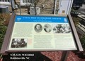 view gallery view galleryN12.6 km |  Civil War in Graham County - Robbinsville NC Civil War in Graham County - Robbinsville NC
in U.S. Civil War Sites During the Civil War, Graham Country (the part of Cherokee County) offered scant support to the secessionist cause, although both ardent Confederates and staunch Unionists lived here. The region was not financially dependent on slavery. posted by: Don.Morfe location: North Carolina date approved: 04/25/2023 last visited: 04/25/2023 |
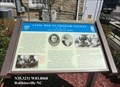 view gallery view galleryN12.6 km | Civil War in Graham County Union and Confederate Raiders - Robbinsville NC in Civil War Discovery Trail Sites During the Civil War, Graham Country (the part of Cherokee County) offered scant support to the secessionist cause, although both ardent Confederates and staunch Unionists lived here. posted by: Don.Morfe location: North Carolina date approved: 05/02/2020 last visited: 10/08/2021 |
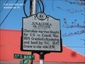
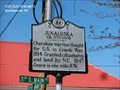 view gallery view galleryN12.7 km | Junaluska in North Carolina Historical Markers Junaluska ca. 1779 - 1858 Cherokee warrior, fought for U.S. in Creek War, 1814. Granted citizenship and land by N.C., 1847. Grave is one mile S.W. posted by: Don.Morfe location: North Carolina date approved: 04/02/2020 last visited: 10/23/2021 |
 view gallery view galleryN12.7 km |  Junaluska - Robbinsville NC Junaluska - Robbinsville NC
in Civil Rights Memorials Junaluska ca. 1779 - 1858 Cherokee warrior, fought for U.S. in Creek War, 1814. Granted citizenship and land by N.C., 1847. Grave is one mile S.W. posted by: Don.Morfe location: North Carolina date approved: 03/18/2023 last visited: 03/17/2023 |
 view gallery view galleryN12.9 km |  Robbinsville McDonalds Robbinsville McDonalds
in McDonald's Restaurants Mc Donalds in Robbinsville NC. posted by: fatcat161 location: North Carolina date approved: 10/11/2008 last visited: 07/20/2008 |
 view gallery view gallery S19 km S19 km
| George W. Truett-Q37 in North Carolina Historical Markers Birthplace of George Truett, Baptist pastor. posted by: Markerman62 location: North Carolina date approved: 08/16/2012 last visited: 07/22/2012 |
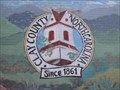 view gallery view galleryS19 km |  Clay County Mural Clay County Mural
in Eagle Scout Project Sites Mural depicting the history of Clay Country, North Carolina. posted by: DudleyGrunt location: North Carolina date approved: 08/26/2009 last visited: never |
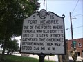 view gallery view galleryS19 km | Fort Hembree Q15 in North Carolina Historical Markers Location of a Trail of Tears fort that housed Cherokees before being moved west. posted by: Markerman62 location: North Carolina date approved: 08/16/2012 last visited: 07/22/2012 |
 view gallery view gallery E19.2 km E19.2 km
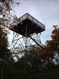
|  Wesser Bald Tower Wesser Bald Tower
in Look-Out Towers Classic steel and wood observation deck. posted by: ar_kayaker location: North Carolina date approved: 09/02/2008 last visited: never |
 view gallery view galleryNW19.6 km |  Surviving In These Rugged Mountains - Shute Cove - near Robbinsville, NC Surviving In These Rugged Mountains - Shute Cove - near Robbinsville, NC
in Signs of History Historic marker pointing out what pioneers here had to deal with posted by: YoSam. location: North Carolina date approved: 12/06/2017 last visited: never |
 view gallery view galleryNW19.6 km |  Shute Cove - Graham County, NC Shute Cove - Graham County, NC
in Satellite Imagery Oddities Scenic overlook, and satellite view of deer harvest sites inside the cove posted by: YoSam. location: North Carolina date approved: 12/07/2017 last visited: never |
 view gallery view galleryNW19.6 km | Shute Cove - near Robbinsville, NC in Scenic Roadside Look-Outs Along the Cherohala Highway.... posted by: YoSam. location: North Carolina date approved: 12/09/2017 last visited: never |
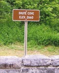 view gallery view galleryNW19.6 km |  Shute Cove - Graham County, NC - 2,660 feet Shute Cove - Graham County, NC - 2,660 feet
in Elevation Signs The Cherohala Skyway between North Carolina and Tennessee travels through the Cherokee National Forest posted by: YoSam. location: North Carolina date approved: 12/04/2017 last visited: never |
 view gallery view galleryE19.6 km | Wayah Bald Tower (John B. Bryne Tower) Near Franklin, North Carolina in Look-Out Towers Located in the Nantahala National Forest. posted by: david28377 location: North Carolina date approved: 10/25/2013 last visited: 07/08/2023 |
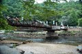 view gallery view galleryNE21.1 km |  Founder's Bridge, Wesser NC Founder's Bridge, Wesser NC
in Truss Bridges Located directly off of highway 74 posted by: CoinsAndPins location: North Carolina date approved: 08/29/2007 last visited: 08/13/2020 |
|