 view gallery view gallery W2.9 km W2.9 km
|   North Carolina / South Carolina on US 276 North Carolina / South Carolina on US 276
in Border Crossings Highway Border Crossing along US 276 - the Pisgah Highway. posted by:  Ernmark Ernmark location: South Carolina date approved: 02/19/2022 last visited: never |
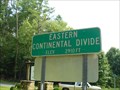 view gallery view galleryW2.9 km |  Eastern Continental Divide - US 276 NC/SC State Line Eastern Continental Divide - US 276 NC/SC State Line
in Watershed Markers and Monuments At the intersection of Greenville Rd (YS 276) and Solomon Rd between Brevard, NC and Ceaser's Head State Park, one can stand in two states and two watersheds at the same time. posted by: NCDaywalker location: North Carolina date approved: 11/02/2017 last visited: 04/07/2021 |
 view gallery view gallery E3.1 km E3.1 km
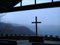
|  "Pretty Place" "Pretty Place"
in Scenic Overlooks This overlook can't be seen from the car. You must park and walk through an open outdoor chapel (Symmes Chapel) which is owned by the YMCA of Greenville County, S.C. It is 5 miles off of Hwy 276 @ the SC/NC State line. posted by: Firefrog69 location: South Carolina date approved: 02/01/2007 last visited: 07/17/2014 |
 view gallery view gallery S3.5 km S3.5 km
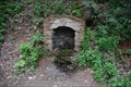
|  Mountain Bridge Wilderness Area Artesian Spring Mountain Bridge Wilderness Area Artesian Spring
in Natural Springs This roadside spring is nicely bricked for easy access. A suitable parking site is approximately 100 ft below the spring. posted by: NCDaywalker location: South Carolina date approved: 05/15/2017 last visited: 05/16/2017 |
 view gallery view gallery N4 km N4 km
|  The Summit The Summit
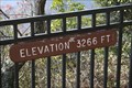
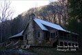
in Elevation Signs This elevation sign is above the hanger located on the airstrip on the top of Dupont State Forest's Airstrip Trail. posted by: Hawaiian Ninja location: North Carolina date approved: 10/25/2010 last visited: never |
 view gallery view gallery SW4 km SW4 km
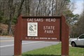
|  Caesars Head State Park - Cleveland,SC Caesars Head State Park - Cleveland,SC
in State/Provincial Parks Caesars Head is one of South Carolina’s most famous natural landmarks. At 3,208 feet above sea level, Caesars Head provides a panoramic view of the mountain country.
posted by: crackergals location: South Carolina date approved: 04/15/2009 last visited: 05/12/2017 |
 view gallery view gallerySW4 km |  Mountain Bridge Wilderness Area - Caesars Head State Park- Cleveland, SC Mountain Bridge Wilderness Area - Caesars Head State Park- Cleveland, SC
in 'You Are Here' Maps Caesars Head State Park has long been a must-see in the South Carolina Upstate. A granitic gneiss outcropping atop the dramatic Blue Ridge Escarpment, it offers breathtaking views year-round, especially when fall sets the hardwoods ablaze.
posted by: crackergals location: South Carolina date approved: 04/16/2009 last visited: 05/12/2017 |
 view gallery view gallerySW4 km |  Caesar's Head Standpipe Caesar's Head Standpipe
in Water Towers A standpipe atop Caesar's Head Mountain. posted by:  Wandering Spirits Wandering Spirits location: South Carolina date approved: 02/15/2008 last visited: 05/12/2017 |
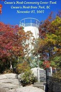 view gallery view gallerySW4 km |  CAESARS HEAD COMMUNITY CTR TK FB3103 CAESARS HEAD COMMUNITY CTR TK FB3103
in U.S. Benchmarks This is an old standpipe tank atop Caesar's Head Mountain located in Caesar's Head State Park. posted by: Wandering Spirits location: South Carolina date approved: 02/18/2008 last visited: 05/12/2017 |
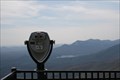 view gallery view gallerySW4 km |  Caesars Head Coin Op Binoculars - Cleveland, SC Caesars Head Coin Op Binoculars - Cleveland, SC
in Coin-Op Binoculars Caesars Head is one of South Carolina’s most famous natural landmarks. At 3,208 feet above sea level, Caesars Head provides a panoramic view of the mountain country.
posted by: crackergals location: South Carolina date approved: 04/17/2009 last visited: 05/12/2017 |
 view gallery view gallerySW4 km | Caesars Head Elevation Sign - Cleveland, SC in Elevation Signs Caesars Head is one of South Carolina’s most famous natural landmarks. At 3,208 feet above sea level, Caesars Head provides a panoramic view of the mountain country.
posted by: crackergals location: South Carolina date approved: 04/15/2009 last visited: 05/12/2017 |
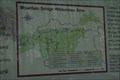
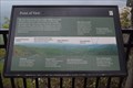 view gallery view gallerySW4 km |  Point of View - Mountain Bridge Wilderness Area - Ceaser's Head State Park Point of View - Mountain Bridge Wilderness Area - Ceaser's Head State Park
in Orientation Tables Following the wooden walkway to the observation area, one finds an orientation board that points out the area landmarks. posted by: NCDaywalker location: South Carolina date approved: 05/28/2017 last visited: 04/07/2021 |
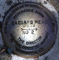 view gallery view gallerySW4 km | CAESARS HEAD RM2 FB3104 in U.S. Benchmarks This is reference mark 2 for the Caesar's Head. posted by: Wandering Spirits location: South Carolina date approved: 02/19/2008 last visited: 04/07/2021 |
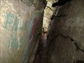 view gallery view gallerySW4 km |  Devil's Kitchen Devil's Kitchen
in Geological Devilish Locations The Devil's Kitchen is a narrow crevice that you can walk through.It is a geological phenomenon formed thousands of years ago by intense pressure and heat. posted by: Firefrog69 location: South Carolina date approved: 06/28/2007 last visited: 07/14/2016 |
 view gallery view galleryE4 km | Jones Gap State Park - South Carolina in State/Provincial Parks Jones Gap State Park posted by: Wandering Spirits location: South Carolina date approved: 02/08/2008 last visited: 10/20/2014 |
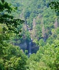 view gallery view gallerySW5.6 km |  Raven Cliff Falls --- Cleveland in Greenville County, South Carolina Raven Cliff Falls --- Cleveland in Greenville County, South Carolina
in Waterfalls Marker is in Cleveland, South Carolina, in Greenville County. Marker can be reached from Geer Highway.Marker is on the gounds of Caesars Head State Park posted by: Countrydragon location: South Carolina date approved: 01/30/2010 last visited: 06/24/1997 |
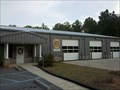
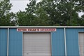 view gallery view galleryS6.6 km |  River Falls Volunteer Fire Department River Falls Volunteer Fire Department
in Firehouses River Falls Volunteer Fire Department located on US 276 serves a local area of Caeser's Head State Park near Cleveland, SC. posted by: NCDaywalker location: South Carolina date approved: 05/16/2017 last visited: 05/16/2017 |
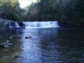
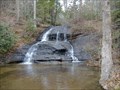 view gallery view galleryS7.2 km | Scenic Hwy.11 Waterfall-Cleveland,SC in Waterfalls A cascade waterfall at a pullover along scenic Hwy.11 near Caesar's head mountain. posted by: Firefrog69 location: South Carolina date approved: 10/10/2007 last visited: 10/22/2013 |
 view gallery view galleryN7.2 km | Hooker Falls in Waterfalls Hooker Falls in located in Dupont State Forest, NC. posted by: papermanone & catlover location: North Carolina date approved: 11/24/2006 last visited: 04/03/2021 |
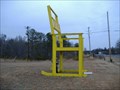 view gallery view galleryS10.1 km |  The Big Rocker The Big Rocker
in Ginormous Everyday Objects A giant roadside attraction off of scenic highway 11 in Pickens County. posted by: Firefrog69 location: South Carolina date approved: 01/28/2007 last visited: 02/25/2009 |
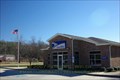 view gallery view gallery SE10.8 km SE10.8 km
|  Cleveland, SC 29635 Cleveland, SC 29635
in U.S. Post Offices Cleveland, SC 29635 Post Office. posted by: Wandering Spirits location: South Carolina date approved: 01/01/2008 last visited: 10/14/2013 |
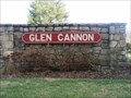 view gallery view gallery NW13.4 km NW13.4 km
|  Glen Cannon Country Club - Brevard, NC Glen Cannon Country Club - Brevard, NC
in Public and Private Golf Courses The Glen Cannon Country Club in Brevard, NC posted by: papermanone & catlover location: North Carolina date approved: 12/25/2006 last visited: never |
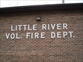 view gallery view galleryN13.5 km | Little River Volunteer Fire Departmant in Firehouses Little River Volunteer Fire Department posted by: papermanone & catlover location: North Carolina date approved: 11/22/2006 last visited: never |
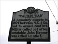 view gallery view galleryNW13.5 km |  Walton War Walton War
in North Carolina Historical Markers This marker is located along the road near Hap Simpson Park. posted by: Hawaiian Ninja location: North Carolina date approved: 06/02/2008 last visited: never |
 view gallery view galleryE13.8 km | Glassy Mountain Fire Department - Beaverdam in Firehouses This firehouse supports the Beaverdam area of Greenville County. posted by: Hawaiian Ninja location: South Carolina date approved: 09/03/2011 last visited: never |
|