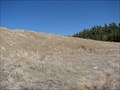
 view gallery view gallery SW2.3 km SW2.3 km
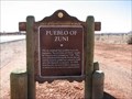
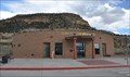
|   Pueblo of Zuni Pueblo of Zuni
in New Mexico Historical Markers The Pueblo of Zuni, a place to step back in history, learn about a Native American culture or buy some fabulous Turquoise jewelery. posted by:  linkys linkys location: New Mexico date approved: 12/17/2009 last visited: 09/24/2010 |
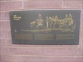
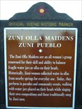 view gallery view gallery E2.4 km E2.4 km
| Zuni Olla Maidens - Zuni Pueblo in New Mexico Historical Markers A New Mexico Historic Women Marker. The New Mexico Historic Women Marker Initiative was founded in 2005 by members of the New Mexico Women's Forum in a statewide effort to recognize women's contributions to New Mexico history. posted by: leadhiker location: New Mexico date approved: 06/11/2011 last visited: never |
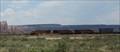
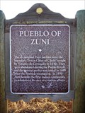 view gallery view gallery W6.8 km W6.8 km
| Pueblo of Zuni in New Mexico Historical Markers This is a second OSHM for the Pueblo of Zuni. The other one is approx. 2.9 miles away at he east end of town. posted by: leadhiker location: New Mexico date approved: 06/11/2011 last visited: never |
 view gallery view galleryE23 km |  Zuni Reservation - New Mexico Zuni Reservation - New Mexico
in Nations Within Nations A traditional Pueblo People with a unique language, culture, and history that is famous for its inlayed silver jewelry, stone fetishes and pottery. posted by: linkys location: New Mexico date approved: 03/31/2008 last visited: 07/29/2014 |
 view gallery view galleryE27.4 km |  The Pioneer Gardener - Ramah, New Mexico The Pioneer Gardener - Ramah, New Mexico
in Figurative Public Sculpture Bronze life size sculpture a woman and child gardening. posted by: linkys location: New Mexico date approved: 04/01/2008 last visited: 05/10/2012 |
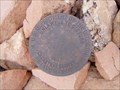 view gallery view galleryE27.8 km |  Cadastral Disk in Ramah, NM Cadastral Disk in Ramah, NM
in U.S. Benchmarks Bureau of Land Management Cadastral Survey Disc on an exercise trail in the community of Ramah, New Mexico, USA posted by:  Hawikuh Hawikuh location: New Mexico date approved: 07/23/2009 last visited: never |
 view gallery view galleryE28 km |  Ramah Water Tower - Ramah, New Mexico Ramah Water Tower - Ramah, New Mexico
in Water Towers Small water tower in a small New Mexico town. posted by: linkys location: New Mexico date approved: 03/31/2008 last visited: 07/28/2014 |
 view gallery view galleryE28.2 km |  Ramah Lake Dam - Ramah, New Mexico Ramah Lake Dam - Ramah, New Mexico
in Water Dams What started as an irrigation dike in the late 1890's is now an earthen dam on the Zuni River. posted by: linkys location: New Mexico date approved: 04/01/2008 last visited: never |
 view gallery view gallery NW37.7 km NW37.7 km
|  Indian Rte. 12 - Lupton, AZ Indian Rte. 12 - Lupton, AZ
in Active Rail Locations Located just off Interstate 40, this spot offers an opportunity to watch trains pass the magnificent cliffs to the South. posted by: rjmcdonough1 location: Arizona date approved: 06/24/2021 last visited: never |
 view gallery view galleryNW38.5 km |  Arizona ~ The Grand Canyon State Arizona ~ The Grand Canyon State
in Welcome Signs This Welcome Sign greets you on westbound Interstate Highway 40 shortly after you have crossed the border from New Mexico. posted by: brwhiz location: Arizona date approved: 11/20/2012 last visited: 10/31/2019 |
 view gallery view galleryNW38.5 km |  One Days Ride to Zuni - Lupton, AZ One Days Ride to Zuni - Lupton, AZ
in Spirit of '76 A historic marker commemorating the bicentennial is erected at the welcome center. posted by: ChapterhouseInc location: Arizona date approved: 11/05/2010 last visited: 09/30/2018 |
 view gallery view galleryNW38.5 km |  One Days Ride to Zuni One Days Ride to Zuni
in Arizona Historical Markers A historic marker commemorating the bicentennial is erected at the welcome center. posted by: ChapterhouseInc location: Arizona date approved: 11/26/2010 last visited: 09/30/2018 |
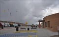
 view gallery view galleryNW38.5 km |  Painted Cliffs Welcome Center ~ Lupton, Arizona Painted Cliffs Welcome Center ~ Lupton, Arizona
in Tourist Information Centers - Visitor Centers This Arizona Welcome Center is located in the Highway Rest Area on the north side of Interstate Highway 40 Exit 359 on the New Mexico/Arizona border. posted by: brwhiz location: Arizona date approved: 11/28/2012 last visited: 09/30/2018 |
 view gallery view galleryNW38.5 km |  Arizona Welcome Center Guest Book Arizona Welcome Center Guest Book
in Guest Books This Guest Book is inside the Arizona Welcome Center on Interstate Highway 40 at Exit 359 on the New Mexico/Arizona border. posted by: brwhiz location: Arizona date approved: 11/20/2012 last visited: 09/30/2018 |
 view gallery view galleryNW38.5 km |  Arizona Welcome Center - I40 Westbound Arizona Welcome Center - I40 Westbound
in Highway Rest Areas Located on I40, this was the first welcome center built in the state for the interstate system. posted by: ChapterhouseInc location: Arizona date approved: 11/02/2010 last visited: 10/31/2019 |
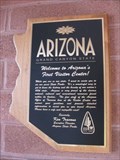 view gallery view galleryNW38.5 km |  Arizona's FIRST Visitor Center Arizona's FIRST Visitor Center
in First of its Kind Located on I40, this was the first welcome center built in the state for the interstate system. posted by: ChapterhouseInc location: Arizona date approved: 10/31/2010 last visited: 09/30/2018 |
 view gallery view galleryNW38.6 km | New Mexico, USA - The Land of Enchantment in Welcome Signs Welcome to New Mexico, Eastbound along I-10 posted by: Sun Chasers location: New Mexico date approved: 04/20/2012 last visited: 09/05/2018 |
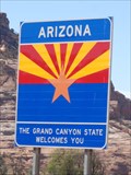 view gallery view galleryNW38.8 km | Welcome Sign - Arizona, USA. in Welcome Signs Arizona - The Grand Canyon State Welcomes You. - The Arizona Welcome Sign welcomes drivers heading West on Route 66, Photos taken from the Arizona welcome center parking lot on Historic Route 66. posted by: veritas vita location: Arizona date approved: 08/09/2014 last visited: 07/01/2021 |
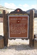 view gallery view galleryNW39.9 km | Manuelito Area in New Mexico Historical Markers Located in the eastbound rest area near Manuelito posted by: Markerman62 location: New Mexico date approved: 10/15/2015 last visited: 11/08/2015 |
 view gallery view galleryNW39.9 km | Manuelito Rest Area in Highway Rest Areas This Highway Rest Area is located on the south side of Interstate Highway 40 about 3 miles east of the Arizona/New Mexico border. posted by: brwhiz location: New Mexico date approved: 07/02/2013 last visited: 09/19/2015 |
 view gallery view galleryNW39.9 km | Manuelito Visitor Center in Tourist Information Centers - Visitor Centers This Tourist Information Center, operated by the New Mexico Department of Transportation, is located on the south side of Interstate Highway 40 just east of the Arizona/New Mexico border. posted by: brwhiz location: New Mexico date approved: 06/30/2013 last visited: 09/19/2015 |
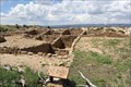 view gallery view galleryE40.1 km |  Atsinna Pueblo ruins -- El Morro National Monument, NM Atsinna Pueblo ruins -- El Morro National Monument, NM
in New World Ancient Evidence The ruins of the Atsinna Pueblo at El Morro National Monument are located on top of the mesa, and are accessible from the Mesa Loop Trail posted by: Benchmark Blasterz location: New Mexico date approved: 08/25/2014 last visited: 01/18/2023 |
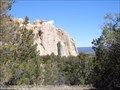
 view gallery view galleryE40.2 km |  Inscription Rock -- El Morro National Monument, NM Inscription Rock -- El Morro National Monument, NM
in Graffiti For thousands of years, human beings ranging from Ancient Puebloans to Spanish conquistadors to pioneers to railroad crews have been scratching their names into Inscription Rock. posted by: Benchmark Blasterz location: New Mexico date approved: 08/22/2014 last visited: 01/18/2023 |
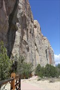
 view gallery view galleryE40.4 km |  Inscription Rock and Mesa Top Trail Loop - El Morro National Monument Inscription Rock and Mesa Top Trail Loop - El Morro National Monument
in Scenic Hikes One trail passes by the base and the other climbs to the top of El Morro, a 200 foot high questa that dominates El Morro National Monument. posted by: linkys location: New Mexico date approved: 04/04/2008 last visited: 01/18/2023 |
 view gallery view galleryE40.4 km |  El Morro National Monument - El Morro NM El Morro National Monument - El Morro NM
in U.S. National Register of Historic Places El Morro National Monument is a U.S. national monument. The monument preserves the remains of a large prehistoric pueblo atop a great sandstone promontory with a pool of water at its base. posted by: Don.Morfe location: New Mexico date approved: 01/21/2023 last visited: 01/18/2023 |
|