 view gallery view gallery NW2.9 km NW2.9 km
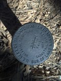
|   BLM Arizona AP 246 BLM Arizona AP 246
in U.S. Benchmarks BLM cadastral marker (iron post with brass cap) for part of a 1977 resurvey of the northern boundary of the Fort Apache India Reservation. posted by:  cphickie cphickie location: Arizona date approved: 04/01/2013 last visited: never |
 view gallery view gallery W12.6 km W12.6 km
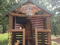
|  Wooden gnome-Pinetop, Arizona Wooden gnome-Pinetop, Arizona
in Outside Wooden Display Carvings Wooden gnome welcoming visitors to Pinetop Vista Cabins. posted by: grandmabetsy location: Arizona date approved: 08/17/2013 last visited: 08/18/2013 |
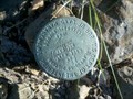 view gallery view galleryW14.5 km |  Dead Man's Curve Boundary Marker Dead Man's Curve Boundary Marker
in U.S. Historic Survey Stones and Monuments Cadastral Survey Marker next to the Dead Man's Curve cache. posted by: frogwarts & bearfr location: Arizona date approved: 05/31/2011 last visited: 09/03/2012 |
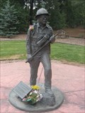 view gallery view galleryW16.7 km |  Wildland Firefighter Memorial - Pinetop-Lakeside, AZ Wildland Firefighter Memorial - Pinetop-Lakeside, AZ
in Firefighter Memorials A memorial to honor all of the wildland firefighters who fought the Rodeo-Chediski Fire of 2002 with a special remembrance of Rick Lupe. posted by: desert georangers location: Arizona date approved: 07/11/2010 last visited: 03/07/2019 |
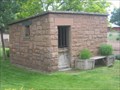 view gallery view galleryW16.9 km |  Old Pinetop Jail Old Pinetop Jail
in WPA Projects The former jail of Pinetop, Arizona was built by the WPA. posted by: desert georangers location: Arizona date approved: 07/02/2010 last visited: 03/07/2019 |
 view gallery view galleryW16.9 km |  Old Pinetop Jail Old Pinetop Jail
in Retired Prisons A small jail building in Pinetop-Lakeside. posted by: desert georangers location: Arizona date approved: 06/30/2010 last visited: 03/07/2019 |
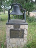 view gallery view galleryW18.3 km |  Bell - Woodland Church and School Bell in Pinetop-Lakeside, AZ Bell - Woodland Church and School Bell in Pinetop-Lakeside, AZ
in Bells An old church and school bell in Pinetop-Lakeside, Arizona. posted by: desert georangers location: Arizona date approved: 06/28/2010 last visited: 05/14/2012 |
 view gallery view galleryW18.3 km |  Lakeside - 436 Lakeside - 436
in D.U.P. Historic Markers Marker is on monument with the Woodland Church and School Bell. Marker is at the intersection of Larson Road and Heritage Lane, on the right when traveling south on Larson Road. posted by:  leadhiker leadhiker location: Arizona date approved: 06/12/2011 last visited: 05/14/2012 |
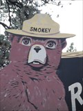
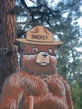 view gallery view galleryNW21.4 km |  Smokey Bear - SR 260, Pinetop-Lakeside, Arizona Smokey Bear - SR 260, Pinetop-Lakeside, Arizona
in Smokey Bear Sign Sightings A Smokey Bear sign in Pinetop-Lakeside, Arizona. posted by: desert georangers location: Arizona date approved: 09/28/2010 last visited: 05/14/2012 |
  E21.9 km E21.9 km
|  Sheep Springs Rail Head Sheep Springs Rail Head
in Sledding Places Take US 260 for 1.5 miles east of the 273 turn off to the parking area. This is the old railroad stop at Sheep Springs. posted by: az_pistolero location: Arizona date approved: 02/06/2006 last visited: never |
 view gallery view galleryNW22 km |  Slow Down near Show Lake, Arizona Slow Down near Show Lake, Arizona
in Unusual Speed Limits Slow Down we don't want your dust. posted by: grandmabetsy location: Arizona date approved: 08/19/2013 last visited: 10/05/2013 |
 view gallery view gallery SE25.9 km SE25.9 km
|  Sunrise Park Resort, Whiteriver, AZ Sunrise Park Resort, Whiteriver, AZ
in Cross Country Ski Trailheads These cross country ski trailheads are located at The Sunrise Park Resort in Whiteriver, AZ. posted by: Poehunters location: Arizona date approved: 08/19/2013 last visited: 08/19/2013 |
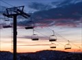 view gallery view gallerySE26.7 km |  Chair Lift - Sunrise Park Resort / nr Greer, AZ Chair Lift - Sunrise Park Resort / nr Greer, AZ
in Aerial Lifts Sunrise Park Resort Chair Lift posted by: ILuvAZ location: Arizona date approved: 07/06/2013 last visited: 07/04/2013 |
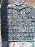 view gallery view galleryNW27.2 km | Showlow Valley Settlement - 250 in D.U.P. Historic Markers Showlow began as a ranch claimed by Marion Clark and Corydon Cooley. posted by: leadhiker location: Arizona date approved: 06/12/2011 last visited: 07/15/2021 |
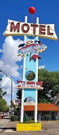 view gallery view galleryNW27.2 km |  Thunderbird Motel - Show Low, AZ Thunderbird Motel - Show Low, AZ
in Neon Signs The majestic Thunderbird Motel is on U.S. 60 in the center of Show Low, Arizona. posted by: rjmcdonough1 location: Arizona date approved: 10/04/2019 last visited: never |
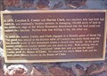 view gallery view galleryNW27.2 km |  "show low and you win the ranch" "show low and you win the ranch"
in Arizona Historical Markers Sculpture of two men, representing Corydon E. Cooley and Marion Clark, sitting at a table playing cards. An extra seat was provided for anyone wanting to join the game. posted by: leadhiker location: Arizona date approved: 06/15/2011 last visited: 09/29/2019 |
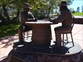 view gallery view galleryNW27.2 km |  Cooley and Clark - Show Low, AZ Cooley and Clark - Show Low, AZ
in Statues of Historic Figures Life-sized amalgamate-bronze sculpture of two men, representing Corydon E. Cooley and Marion Clark, sitting at a table playing cards. An extra seat was provided for anyone wanting to join the game. posted by: leadhiker location: Arizona date approved: 06/14/2011 last visited: 05/29/2021 |
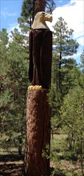 view gallery view galleryNW30.1 km | The Eagle in Show Low, Arizona in Outside Wooden Display Carvings The eagle is watching you.. posted by: grandmabetsy location: Arizona date approved: 08/18/2013 last visited: 07/01/2021 |
 view gallery view galleryE30.7 km | Smokey Bear - SR 373, Greer, Arizona in Smokey Bear Sign Sightings A Smokey Bear sign in Greer, Arizona. posted by: desert georangers location: Arizona date approved: 09/28/2010 last visited: 07/01/2012 |
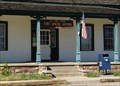 view gallery view gallery SW38.5 km SW38.5 km
|  Fort Apache, AZ 85926 Fort Apache, AZ 85926
in U.S. Post Offices Rehabilitated in 2001, it continues to serve Fort Apache and surrounding communities as the U.S. Post Office. posted by: leadhiker location: Arizona date approved: 06/13/2011 last visited: never |
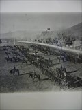 view gallery view gallerySW38.8 km |  Fort Apache, Fort Apache, AZ Fort Apache, Fort Apache, AZ
in Historic Forts On May 16, 1870 troops from the 21st Infantry and 1st cavalry began construction of Camp Ord. The camp would be renamed Camp Mogollon, then Camp Thomas, and finally, Camp Apache. The post was designated Fort Apache in 1879. posted by: leadhiker location: Arizona date approved: 06/13/2011 last visited: never |
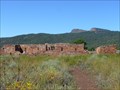 view gallery view gallerySW39.4 km |  Kinishba Ruins - Arizona Kinishba Ruins - Arizona
in U.S. National Register of Historic Places Kinishba is the ruins of a pueblo capable of housing up to 1000 people, abandoned about 1400 AD. posted by: leadhiker location: Arizona date approved: 06/19/2011 last visited: never |
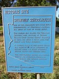 view gallery view galleryNW42.3 km | Shumway Schoolhouse in Arizona Historical Markers One of the remaining one-room brick schoolhouses in Northern Arizona. posted by: leadhiker location: Arizona date approved: 06/15/2011 last visited: never |
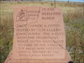 view gallery view galleryE43.6 km | 26 Bar Hereford Ranch in Arizona Historical Markers This is stop #8 on the Pistols, Plows & Petticoats driving tour. posted by: leadhiker location: Arizona date approved: 06/15/2011 last visited: never |
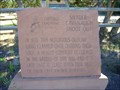 view gallery view galleryE45.7 km | Snyder-Cavanaugh Shoot Out in Arizona Historical Markers This is stop #6 on the Pistols, Plows & Petticoats tour. posted by: leadhiker location: Arizona date approved: 06/15/2011 last visited: never |
|