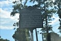
 view gallery view gallery SE3.5 km SE3.5 km
|   D-16 Spanish Attack D-16 Spanish Attack
in North Carolina Historical Markers "A Spanish expedition captured the town of Brunswick, 1748, during King George's War, but was soon driven away by the colonial militia." posted by:  NCDaywalker NCDaywalker location: North Carolina date approved: 08/25/2016 last visited: 08/26/2016 |
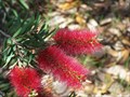 view gallery view gallerySE3.5 km |  Orton Gardens and Plantation Orton Gardens and Plantation
in Botanical Gardens A beautiful plantaion and gardens along the coast of the Cape Fear River. posted by:  GT.US GT.US location: North Carolina date approved: 05/15/2007 last visited: never |
 view gallery view gallery S4 km S4 km
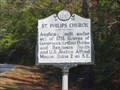
| St. Philips Church-D-55 in North Carolina Historical Markers Marker is near Winnabow, North Carolina, in Brunswick County. Marker is at the intersection of Plantation Road and Orton Road, on the left when traveling south on Plantation Road posted by: Countrydragon location: North Carolina date approved: 12/17/2009 last visited: 02/16/2023 |
 view gallery view galleryS4 km | Brunswick-D54 in North Carolina Historical Markers Marker is near Winnabow, North Carolina, in Brunswick County. Marker is on Plantation Road near Orton Road, on the left when traveling south. posted by: Countrydragon location: North Carolina date approved: 12/17/2009 last visited: 08/20/2016 |
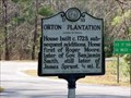 view gallery view galleryS4 km | Orton Plantation-D-53 in North Carolina Historical Markers Marker is in Winnabow, North Carolina, in Brunswick County. Marker is at the intersection of Plantation Road and Orton Road, on the left when traveling south on Plantation Road. posted by: Countrydragon location: North Carolina date approved: 12/17/2009 last visited: 02/22/2018 |
 view gallery view gallery N4.7 km N4.7 km
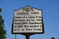
| D-48 Charles Town in North Carolina Historical Markers Marker Text:
"Center of a colony from Barbados led by John Vassall, 1664. Abandoned by 1667. Was located 2 mi. E. on Town Creek." posted by: NCDaywalker location: North Carolina date approved: 05/15/2017 last visited: 05/15/2017 |
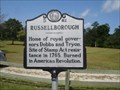 view gallery view galleryS6.3 km | Russellborough-D-82-Brunswick NC in North Carolina Historical Markers SR 1533 (St. Philips Church Road) at Brunswick Town State Historic Site posted by: Countrydragon location: North Carolina date approved: 12/13/2009 last visited: 12/07/2017 |
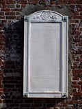
 view gallery view galleryS6.3 km | Russelborough-Brunswick Town State Historic Site, North Carolina in North Carolina Historical Markers Erected 1909 by North Carolina Society of the Colonial Dames of America posted by: Countrydragon location: North Carolina date approved: 12/15/2009 last visited: 02/16/2023 |
 view gallery view gallery E6.6 km E6.6 km
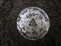
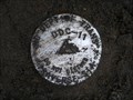
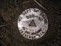
|  NCDOT - DDC12 NCDOT - DDC12
in U.S. Benchmarks In the dirt median of Carolina Beach Rd, a North Carolina Department of Transportation traverse station stamped DDC-12 posted by: wwflover13 location: North Carolina date approved: 02/14/2009 last visited: never |
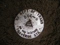
 view gallery view galleryE6.8 km | NCDOT - DDC11 in U.S. Benchmarks In the dirt median of Carolina Beach Rd, a North Carolina Department of Transportation traverse station stamped DDC-11 posted by: wwflover13 location: North Carolina date approved: 02/14/2009 last visited: never |
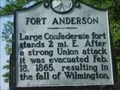 view gallery view galleryS6.9 km | FORT ANDERSON-DDD-1 in North Carolina Historical Markers Located on NC 133 at Brunswick Town State Historic Site posted by: Countrydragon location: North Carolina date approved: 12/17/2009 last visited: 02/16/2023 |
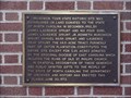 view gallery view galleryS6.9 km |  Brunswick Town State Historic Site - Near Winnabow in Brunswick County, North Carolina Brunswick Town State Historic Site - Near Winnabow in Brunswick County, North Carolina
in Signs of History Marker is near Winnabow, North Carolina, in Brunswick County. Marker is on St. Philips Road east of River Road (North Carolina Route 133).Follow the signs on River Road. Take Plantation Road to St. Philips Road. posted by: Countrydragon location: North Carolina date approved: 12/29/2009 last visited: 02/16/2023 |
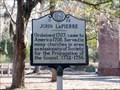 view gallery view galleryS6.9 km | John LaPierre-D-73 in North Carolina Historical Markers Marker is in Winnabow, North Carolina, in Brunswick County. Marker is at the intersection of St. Philips Road and Plantation Road on St. Philips Road. posted by: Countrydragon location: North Carolina date approved: 12/17/2009 last visited: 02/16/2023 |
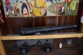 view gallery view galleryS6.9 km |  Fortuna 6 pound Cannon - Fort Anderson/Brunswick Town - Winnabow, NC, USA Fortuna 6 pound Cannon - Fort Anderson/Brunswick Town - Winnabow, NC, USA
in Static Artillery Displays In the museum at Fort Anderson/Brunswick Town near Winnabow, NC, a six-pound cannon from the Spanish ship Fortuna is displayed for viewers. posted by: NCDaywalker location: North Carolina date approved: 04/26/2017 last visited: 04/28/2017 |
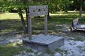 view gallery view galleryS6.9 km |  Fort Anderson - Pillory display - Winnabow, NC Fort Anderson - Pillory display - Winnabow, NC
in Punishment and Disciplinary Devices Fort Anderson, a Civil War era fort, is a state historic site with many outdoor exhibits and a well-maintained museum. posted by: NCDaywalker location: North Carolina date approved: 03/22/2017 last visited: 02/16/2023 |
 view gallery view galleryS6.9 km | 32 pounder Cannon - Fort Anderson- Winnabow, NC, USA in Static Artillery Displays In the Fort Anderson Historic Site, the 32 pounder and carriage are near the visitor center. posted by: NCDaywalker location: North Carolina date approved: 09/22/2016 last visited: 12/07/2018 |
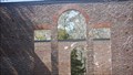 view gallery view galleryS6.9 km |  St. Phillps Church Ruins - Brunswick Town, NC St. Phillps Church Ruins - Brunswick Town, NC
in U.S. National Register of Historic Places These walls have stood through the American Revolution and the Civil War. 250 years of history. posted by: FRESH AIR53 location: North Carolina date approved: 01/16/2019 last visited: 02/16/2023 |
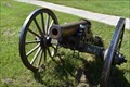 view gallery view galleryS6.9 km | Civil War 6 Pounder Cannon - Ft Anderson Historic Site - Winnabow, NC, USA in Static Artillery Displays "The 6-pounder field gun was a lightweight, mobile piece that was a favorite of the field artillery in the first half of the nineteenth century."
There are two on display approx 50 yards apart. posted by: NCDaywalker location: North Carolina date approved: 08/29/2016 last visited: 12/07/2018 |
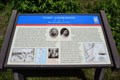
 view gallery view galleryS6.9 km | Colonel Maurice Moore - Winnabow in Brunswick County, North Carolina in Signs of History Marker is in Winnabow, North Carolina, in Brunswick County. Marker can be reached from St. Philips Road.It is in the Brunswick Town Historic Site inside the church ruins posted by: Countrydragon location: North Carolina date approved: 01/02/2010 last visited: 02/16/2023 |
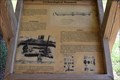
 view gallery view galleryS6.9 km |  Fort Anderson One Shovelful at a Time - Winnabow, NC, USA Fort Anderson One Shovelful at a Time - Winnabow, NC, USA
in Civil War Discovery Trail Sites Just off NC 133 near Winnabow, Fort Anderson and Brunswick Town Remains await a great day of exploring some of our history from the Civil War and Colonial Days. posted by: NCDaywalker location: North Carolina date approved: 01/04/2018 last visited: 12/07/2018 |
 view gallery view galleryS6.9 km |  Brunswick Town State Historic Site, near Boiling Springs Lake, NC Brunswick Town State Historic Site, near Boiling Springs Lake, NC
in Preserved Architectural Remnants and Ruins "A major pre-Revolutionary port on North Carolina's Cape Fear River, Brunswick was razed by British troops in 1776 and never rebuilt." posted by: NCDaywalker location: North Carolina date approved: 08/21/2016 last visited: 02/17/2018 |
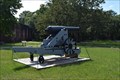
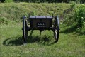 view gallery view galleryS6.9 km |  Civil War Caisson - Ft Anderson Historic Site - Winnabow, NC Civil War Caisson - Ft Anderson Historic Site - Winnabow, NC
in Military Ground Equipment Displays At the restored fort, one can find a battery of two cannons and two caissons. These are restored to like 1865 condition. posted by: NCDaywalker location: North Carolina date approved: 09/01/2016 last visited: 12/07/2018 |
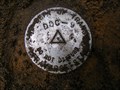
 view gallery view galleryE6.9 km | NCDOT - DDC10 in U.S. Benchmarks In the dirt median of Carolina Beach Rd, a North Carolina Department of Transportation traverse station stamped DDC-10 posted by: wwflover13 location: North Carolina date approved: 02/14/2009 last visited: never |
 view gallery view galleryE7.1 km | NCDOT - DDC9 in U.S. Benchmarks In the dirt median of Carolina Beach Rd, a North Carolina Department of Transportation traverse station stamped DDC-9 posted by: wwflover13 location: North Carolina date approved: 02/14/2009 last visited: never |
 view gallery view galleryE7.1 km | NCDOT - DDC8 in U.S. Benchmarks In the dirt median of Carolina Beach Rd, a North Carolina Department of Transportation traverse station stamped DDC-8 posted by: wwflover13 location: North Carolina date approved: 02/14/2009 last visited: never |
|