 view gallery view gallery SW0.6 km SW0.6 km
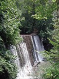
|   Roswell Mill Dam on Vickery Creek, Roswell, GA Roswell Mill Dam on Vickery Creek, Roswell, GA
in Water Dams Roswell Mill Dam is a 30-foot dam and millrace that was constructed on Vickery Creek in the mid-to-late 1830s to supply power for the Roswell mills.
posted by:  Lat34North Lat34North location: Georgia date approved: 08/08/2007 last visited: 03/03/2011 |
 view gallery view gallery S0.6 km S0.6 km
|  The Cherokee Nation - Roswell, GA The Cherokee Nation - Roswell, GA
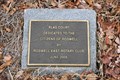
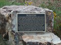
in Georgia Historical Markers One of eight plaques mounted to boulder in honor of The Cherokee Nation and in remembrance of ”The Trail of tears”. Located in the Riverside Park on Riverside Rd, Roswell, Ga. posted by: Lat34North location: Georgia date approved: 07/25/2014 last visited: 07/23/2014 |
 view gallery view galleryS0.8 km |  Roswell, GA Roswell, GA
in Municipal Flags Roswell is a city located in northern Fulton County and an affluent suburb of northern Atlanta, Georgia. This flag flies at the park at 575 Riverside Rd. posted by: Lat34North location: Georgia date approved: 03/18/2010 last visited: 05/12/2011 |
 view gallery view galleryS0.8 km |  Flag Court - Riverside Park - Roswell, GA Flag Court - Riverside Park - Roswell, GA
in Rotary International Markers Flag Court donated by the Roswell East Rotary Club to the citizens of Roswell. The plaque is at the base of the flags located in Riverside Park on Riverside Rd, Roswell, GA. posted by: Lat34North location: Georgia date approved: 03/18/2010 last visited: 05/12/2011 |
 view gallery view galleryS0.8 km | Eyewitnesses to Horror - Roswell, GA in Georgia Historical Markers One of eight plaques mounted to boulder in honor of The Cherokee Nation and in remembrance of ”The Trail of tears”. Located in the Riverside Park on Riverside Rd, Roswell, Ga. posted by: Lat34North location: Georgia date approved: 07/25/2014 last visited: 07/23/2014 |
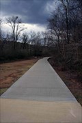
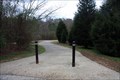 view gallery view galleryS0.8 km |  Riverwalk Trail - Riverside Rd. - Roswell GA Riverwalk Trail - Riverside Rd. - Roswell GA
in Hiking and walking trailheads This paved trail winds along the edge of the Chattahoochee River. There are several access points along the trail. One is located at 575 Riverside Dr. posted by: Lat34North location: Georgia date approved: 03/18/2010 last visited: 03/12/2011 |
 view gallery view galleryS0.8 km | The Georgia Land Lottery of 1832 - Roswell, GA in Georgia Historical Markers One of eight plaques mounted to boulder in honor of The Cherokee Nation and in remembrance of ”The Trail of tears”. Located in the Riverside Park on Riverside Rd, Roswell, Ga. posted by: Lat34North location: Georgia date approved: 07/25/2014 last visited: 07/23/2014 |
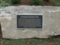
 view gallery view galleryS0.8 km | To Honor Those Who Came Before US - Roswell, GA in Georgia Historical Markers One of eight plaques mounted to boulder in honor of The Cherokee Nation and in remembrance of ”The Trail of tears”. Located in the Riverside Park on Riverside Rd, Roswell, Ga. posted by: Lat34North location: Georgia date approved: 07/25/2014 last visited: 07/23/2014 |
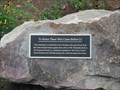
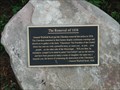 view gallery view galleryS0.8 km | The Removal of 1838 - Roswell, GA in Georgia Historical Markers One of eight plaques mounted to boulder in honor of The Cherokee Nation and in remembrance of ”The Trail of tears”. Located in the Riverside Park on Riverside Rd, Roswell, Ga. posted by: Lat34North location: Georgia date approved: 07/25/2014 last visited: 07/23/2014 |
 view gallery view gallery N0.8 km N0.8 km
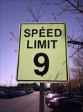
|  9 MPH at Roswell, Georgia Adult Recreation Facility 9 MPH at Roswell, Georgia Adult Recreation Facility
in Unusual Speed Limits A nine MPH speed limit at the Roswell, GA Adult Recreation facility. posted by:  Rat Rat Rat Rat location: Georgia date approved: 04/06/2011 last visited: 04/05/2011 |
 view gallery view galleryS0.8 km | The Trail of Tears - Roswell, GA in Georgia Historical Markers One of eight plaques mounted to boulder in honor of The Cherokee Nation and in remembrance of ”The Trail of tears”. Located in the Riverside Park on Riverside Rd, Roswell, Ga. posted by: Lat34North location: Georgia date approved: 07/25/2014 last visited: 07/23/2014 |
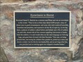
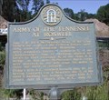 view gallery view galleryS0.8 km | Army of the Tennessee at Roswell - GHM 033-95 – Cobb Co., GA. in Georgia Historical Markers July 3, 16, 1864. McPherson's Army of the Tenn. formed the right of the Federal forces operating south of Kennesaw Mountain. (marker was moved to a new location) posted by: Lat34North location: Georgia date approved: 10/01/2007 last visited: 04/25/2021 |
 view gallery view gallerySW1 km |  Riverwalk Trail - Riverside Rd. - Roswell GA Riverwalk Trail - Riverside Rd. - Roswell GA
in Non-Coastal Boardwalks This boardwalk is part Riverwalk Trail and it crosses the floodplain of the Chattahoochee River and Vickery Creek. There are several access points to the trail. The closest is at 575 Riverside Rd. posted by: Lat34North location: Georgia date approved: 03/18/2010 last visited: 03/12/2011 |
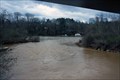 view gallery view gallerySW1 km |  CONFLUENCE - Vickery Creek - Chattahoochee River CONFLUENCE - Vickery Creek - Chattahoochee River
in River Origins, Destinations and Confluences The CONFLUENCE of Vickery Creek with the Chattahoochee River is viewable from the west end of the bridge over Vickery Creek along Riverwalk Trail. Closest parking is at the Riverside Park on Riverside Rd. posted by: Lat34North location: Georgia date approved: 04/17/2010 last visited: 04/11/2011 |
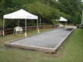 view gallery view galleryN1 km |  Roswell Adult Recreation Center (Roswell, GA) Roswell Adult Recreation Center (Roswell, GA)
in Lawn Bowling Roswell, GA: Bocce court in back of the Roswell Adult Recreation Center posted by: The Yoyo Man location: Georgia date approved: 08/30/2009 last visited: 04/05/2011 |
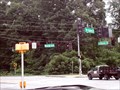 view gallery view gallerySW1 km |  Quadrivia in Roswell, GA Quadrivia in Roswell, GA
in Quadrivia This is a major intersection in Roswell GA. Roswell Road becomes Atlanta Street and Azalea Drive becomes Riverside Drive. posted by: Lat34North location: Georgia date approved: 08/19/2014 last visited: 07/26/2014 |
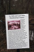 view gallery view gallerySW1 km | Ivy Mills and Laurel Mills Manufacturing Company - Fulton Co., GA in Georgia Historical Markers Located along the Riverwalk Trail near Roswell Rd and Riverside Rd. Closest trail entrance is at the facilities at 575 Riverside Dr. marker is west of the parking lot along the paved trail. posted by: Lat34North location: Georgia date approved: 03/19/2010 last visited: 05/12/2011 |
 view gallery view gallery W1 km W1 km
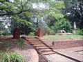
|  Founders Cemetery - Roswell, Ga., USA Founders Cemetery - Roswell, Ga., USA
in Worldwide Cemeteries Roswell Ga. Founders Cemeter, 1840 - 1860. Located at the end of Sloan Street, Roswell, Ga. posted by: Lat34North location: Georgia date approved: 07/14/2007 last visited: 04/21/2011 |
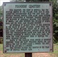 view gallery view galleryW1 km | Founders Cemetery, Roswell, Ga. in Georgia Historical Markers Founders Cemetery 1840-1860, contains 23 marked graves of some first families of Roswell and their slaves. posted by: Lat34North location: Georgia date approved: 07/13/2007 last visited: 04/21/2011 |
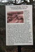 view gallery view gallerySW1 km | Covered Bridge over the Chattahoochee River - Fulton Co., GA in Georgia Historical Markers Located along the Johnson Ferry Trail near Roswell Rd and Riverside Rd. Closest trail entrance is at the facilities at 575 Riverside Dr. marker is west of the parking lot along the paved trail. posted by: Lat34North location: Georgia date approved: 03/19/2010 last visited: 03/13/2011 |
 view gallery view gallerySW1 km | The Eternal Flame - Roswell, GA in Georgia Historical Markers One of eight plaques mounted to boulder in honor of The Cherokee Nation and in remembrance of ”The Trail of tears”. Located in the Riverside Park on Riverside Rd, Roswell, Ga. posted by: Lat34North location: Georgia date approved: 07/25/2014 last visited: 07/23/2014 |
 view gallery view gallerySW1.1 km | Native Americans in Roswell - Roswell, GA in Georgia Historical Markers One of eight plaques mounted to boulder in honor of The Cherokee Nation and in remembrance of ”The Trail of tears”. Located in the Riverside Park on Riverside Rd, Roswell, Ga. posted by: Lat34North location: Georgia date approved: 07/25/2014 last visited: 07/23/2014 |
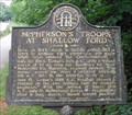 view gallery view gallerySW1.1 km | McPherson's Troops at Shallow Ford - GHM 060-6 - Roswell, Fulton Co. GA in Georgia Historical Markers Here, in 1824, Jacob R. Brooks established a ferry at Shallow Ford where the old Hightower Trail crossed the Chattahoochee.
July 10, 1864. Dodge's 16th A.C., after a forced march of 27 mi. from the Sandtown Rd. (near Mabletown), via Marietta. posted by: Lat34North location: Georgia date approved: 07/18/2007 last visited: 02/28/2011 |
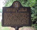 view gallery view gallerySW1.1 km | Garrard's Cav. & Newton's Division - GHM 060-5 - Roswell, Fulton Co., Ga. in Georgia Historical Markers GARRARD'S CAV. & NEWTON'S DIVISION
July 9, 1864. Roswell bridge, having been destroyed by the retreating Confederates, Garrard's cav. [Union] waded the river at Shallow Ford in face of opposition from the south side. posted by: Lat34North location: Georgia date approved: 07/18/2007 last visited: 02/28/2011 |
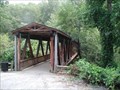 view gallery view galleryW1.3 km |  Vickery Creek covered bridge - Roswell, Ga Vickery Creek covered bridge - Roswell, Ga
in Covered Bridges Vickery Creek covered bridge is located in the Old Mill Park in Roswell Ga. It is a foot bridge that crosses Vickery Creek and connects the Vickery Creek Unit of the Chattahoochee River National Recreation Area to Roswell Mill. posted by: Lat34North location: Georgia date approved: 08/07/2007 last visited: 05/19/2012 |
|