 view gallery view gallery S10.5 km S10.5 km
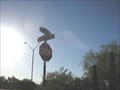
|   Casey's street Casey's street
in Your Name Here Casey Surname Street Sign posted by:  ILuvAZ ILuvAZ location: Arizona date approved: 06/20/2013 last visited: 01/04/2019 |
 view gallery view gallery SE13.5 km SE13.5 km
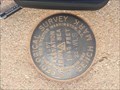
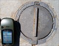
|  USGS BENCH MARK 1957 - 1845 feet, 22 WLS - 1957 USGS BENCH MARK 1957 - 1845 feet, 22 WLS - 1957
in U.S. Benchmarks This marker gives the elevation at this location. posted by: T2D location: Arizona date approved: 01/11/2019 last visited: 01/02/2021 |
 view gallery view gallery W15.9 km W15.9 km
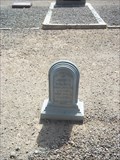
|  Eagle Eye Cemetery - Aguila, Arizona Eagle Eye Cemetery - Aguila, Arizona
in Worldwide Cemeteries Eagle Eye Cemetery, a very quiet cemetery with views that lend to lots of peace and the ability to just breathe! posted by: T2D location: Arizona date approved: 01/23/2019 last visited: 01/23/2019 |
 view gallery view galleryW15.9 km |  "Eagele Eye Cemetary" - Aguila, Arizona "Eagele Eye Cemetary" - Aguila, Arizona
in Human Error The name of the Eagle Eye Cemetery seems to have taken on a new spelling. posted by: T2D location: Arizona date approved: 06/11/2019 last visited: never |
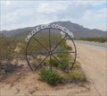
 view gallery view gallery E16.9 km E16.9 km
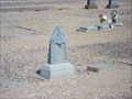
| Verde Flat Cemetery aka Vulture City Cemetery, Vulture City, Arizona in Worldwide Cemeteries Verde Flat Cemetery AKA Vulture City Pioneer Cemetery. Circa 1870. This historic piece of land gets little notice and few visitors although it is only 1/4 mile from Vulture City Mine. posted by: T2D location: Arizona date approved: 01/23/2019 last visited: never |
 view gallery view gallery NW17.9 km NW17.9 km
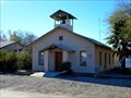
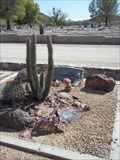
|  Iglesia Evangelica Nazaret - Aguila, AZ Iglesia Evangelica Nazaret - Aguila, AZ
in Religious Buildings Multifarious This building houses the Evangelical Church of Christ in the community of Aguila. posted by: rjmcdonough1 location: Arizona date approved: 01/23/2019 last visited: never |
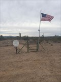
 view gallery view gallery NE18 km NE18 km
| 4NL1 - Height Modernization Survey Station in U.S. Benchmarks PID AJ3628
STATE/COUNTY AZ/MARICOPA
USGS QUAD VULTURE PEAK (1990) posted by: Arizona Ranger Team location: Arizona date approved: 06/11/2011 last visited: never |
 view gallery view galleryNW18 km |  Aguila, AZ Aguila, AZ
in Wikipedia Entries Aguila is a census designated place in the northwest corner of Maricopa County, Arizona. posted by: rjmcdonough1 location: Arizona date approved: 01/24/2019 last visited: never |
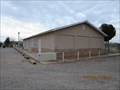
 view gallery view galleryNW18.5 km | Community Bible Church - Aguila, AZ in Religious Buildings Multifarious The Community Bible Church is located on 1st Ave. in Aguila, Arizona. posted by: rjmcdonough1 location: Arizona date approved: 01/24/2019 last visited: never |
 view gallery view galleryNW18.5 km |  Community Bible Church Bell Tower - Aguila, AZ Community Bible Church Bell Tower - Aguila, AZ
in Bell Towers This short tower houses the bell atop the Community Bible Church. posted by: rjmcdonough1 location: Arizona date approved: 02/02/2019 last visited: never |
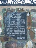 view gallery view galleryNE24.5 km |  Wickenburg Massacre Wickenburg Massacre
in Arizona Historical Markers On the morning of November 5th, 1871, a stagecoach carrying seven passengers and driver was ambushed eight miles west of Wickenburg while en- route to Culling’s Well, Ehrenburg and San Bernardino. This event led to the death of seven people. posted by:  leadhiker leadhiker location: Arizona date approved: 05/25/2010 last visited: 11/26/2015 |
 view gallery view galleryNE26.4 km | Vulture Mine in Arizona Historical Markers The Vulture Mine produced gold worth more than 200 million dollars. The mine sparked the development of Arizona and the city of Phoenix. posted by: leadhiker location: Arizona date approved: 05/25/2010 last visited: 12/05/2018 |
 view gallery view galleryNE28.8 km |  Glen and Susie Shorter - Wickenburg Municipal Cemetery - Arizona Glen and Susie Shorter - Wickenburg Municipal Cemetery - Arizona
in Homemade Tombstones Five stones make up this husband and wife paired grave. Four of these are hand carved from stone. posted by:  Tsegi Mike and Desert Viking Tsegi Mike and Desert Viking location: Arizona date approved: 09/06/2011 last visited: 03/28/2014 |
 view gallery view galleryNE28.8 km |  Howard L. Coffinger Plaque - Wickenburg, Arizona, USA Howard L. Coffinger Plaque - Wickenburg, Arizona, USA
in Citizen Memorials Dedicated to a man who cared for this cemetery. posted by: Tsegi Mike and Desert Viking location: Arizona date approved: 09/06/2011 last visited: 09/06/2011 |
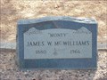 view gallery view galleryNE28.8 km |  James Monty McWilliams - Wickenburg Municipal Cemetery - Arizona, USA James Monty McWilliams - Wickenburg Municipal Cemetery - Arizona, USA
in Occupational/Hobby Grave Stones A tiny picture on his tombstone reflects something he was renowned for. posted by: Tsegi Mike and Desert Viking location: Arizona date approved: 09/07/2011 last visited: 09/10/2011 |
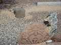
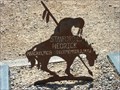 view gallery view galleryNE28.8 km | Stanford L. Hedrick - Wickenburg Municipal Cemetery - Arizona in Homemade Tombstones Between his parents' graves is a metal cutout of a mourning Indian on top of a horse. The name and dates of the deceased are cut out of this image. posted by: Tsegi Mike and Desert Viking location: Arizona date approved: 09/06/2011 last visited: 11/02/2015 |
 view gallery view galleryNE28.8 km |  John C. Egloff - Wickenburg Municipal Cemetery - Wickenburg, Arizona, USA John C. Egloff - Wickenburg Municipal Cemetery - Wickenburg, Arizona, USA
in Zinc Headstones One of two small zinc markers in this cemetery. posted by: Tsegi Mike and Desert Viking location: Arizona date approved: 09/06/2011 last visited: 09/10/2011 |
 view gallery view galleryNE28.8 km | Thomas A. Woods - Wickenburg Municipal Cemetery - Wickenburg, Arizona, USA in Zinc Headstones One of two zinc markers in this western cemetery. posted by: Tsegi Mike and Desert Viking location: Arizona date approved: 09/06/2011 last visited: 09/10/2011 |
 view gallery view galleryNE29 km | Wickenburg Municipal Cemetery - Wickenburg, Arizona, USA in Worldwide Cemeteries The town cemetery is well cared for. posted by: Tsegi Mike and Desert Viking location: Arizona date approved: 09/08/2011 last visited: 09/10/2011 |
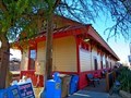
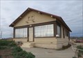 view gallery view galleryNE29.9 km |  Santa Fe Section House - Wickenburg, AZ Santa Fe Section House - Wickenburg, AZ
in U.S. National Register of Historic Places This building housed the foreman of the section crew for the Santa Fe Railroad. posted by: rjmcdonough1 location: Arizona date approved: 01/26/2019 last visited: never |
 view gallery view galleryNE29.9 km | Santa Fe Railroad Depot - Wickenburg, AZ in U.S. National Register of Historic Places The Santa Fe railroad station was constructed in 1895 following the arrival of the rail line in 1894. posted by: rjmcdonough1 location: Arizona date approved: 01/15/2019 last visited: never |
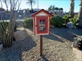 view gallery view galleryNE29.9 km |  Little Free Library #60849 - Wickenburg, AZ Little Free Library #60849 - Wickenburg, AZ
in Free Community Book Exchanges This book exchange stands next to the historic railway station in Wickenburg. posted by: rjmcdonough1 location: Arizona date approved: 01/05/2019 last visited: never |
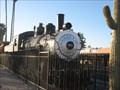 view gallery view galleryNE29.9 km |  ATSF #761 - Wickenburg, AZ ATSF #761 - Wickenburg, AZ
in Locomotives A retired train locomotive in Wickenburg, Arizona. posted by: desert georangers location: Arizona date approved: 03/25/2011 last visited: 06/15/2022 |
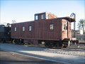 view gallery view galleryNE29.9 km |  SP #604 Caboose - Wickenburg, AZ SP #604 Caboose - Wickenburg, AZ
in Train Cabooses A retired drover's caboose in Wickenburg, Arizona. posted by: desert georangers location: Arizona date approved: 03/29/2011 last visited: 06/15/2022 |
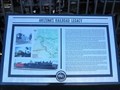 view gallery view galleryNE29.9 km | Arizona's Railroad Legacy - Wickenburg, AZ in Arizona Historical Markers This plaque, describing Arizona's railroad development, is outside the historic Wickenburg Santa Fe Railroad station. posted by: rjmcdonough1 location: Arizona date approved: 01/15/2019 last visited: 06/15/2022 |
|