 view gallery view gallery W0 km W0 km
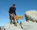
|   Mt. San Jacinto, California Mt. San Jacinto, California
in Mountain Summits Mt. San Jacinto is a 10,834 foot peak above Palm Springs. It is the second highest peak in Southern California. posted by:  showbizkid showbizkid location: California date approved: 01/27/2006 last visited: 05/20/2015 |
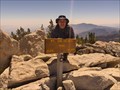 view gallery view galleryW0 km |  Highest Point in Riverside County, Mt San Jacinto Highest Point in Riverside County, Mt San Jacinto
in Geographic High Points Mt San Jacinto is the Highest Point in Riverside County posted by:  Rumpled Rumpled location: California date approved: 01/10/2010 last visited: 05/20/2015 |
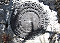
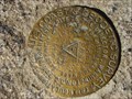 view gallery view gallery NW0 km NW0 km
|  San Jacinto Peak Triangulation disk San Jacinto Peak Triangulation disk
in U.S. Benchmarks Benchmark DX5119
This benchmark can be found at the second highest point in southern California at an elevation of 10,834 feet above sea level. posted by: Moag Ohana location: California date approved: 01/08/2008 last visited: 11/16/2017 |
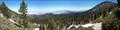 view gallery view galleryNW0 km |  Santa Rosa and San Jacinto Mountains - San Jacinto Peak Santa Rosa and San Jacinto Mountains - San Jacinto Peak
in National Parks of the World San Jacinto Peak is the second highest peak in Southern California. It has the second steepest elevation gain in the nation. posted by: TerryDad2 location: California date approved: 08/28/2006 last visited: 05/20/2015 |
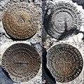 view gallery view gallery S0.3 km S0.3 km
| SAN JACINTO Azimuth Disk w/ Triangulation Station Disks - PID DX5119 in U.S. Benchmarks Azimuth Mark Disk for Triangulation Station "SAN JACINTO" along with all three benchmark disks for the station itself. posted by: Vader! location: California date approved: 06/29/2009 last visited: 05/20/2015 |
 view gallery view galleryS0.3 km |  SAN JACINTO 1898 1923 SET 1954 - California SAN JACINTO 1898 1923 SET 1954 - California
in Azimuth Benchmarks Azimuth Mark Disk mentioned in 1954 Documented History for Triangulation Station "SAN JACINTO" (PID DX5119), along with all three benchmark disks for the station itself. posted by: Vader! location: California date approved: 06/29/2009 last visited: 05/20/2015 |
 view gallery view gallery E0.6 km E0.6 km
| Miller Peak in Mountain Summits Miller Peak on the East flank of San Jacinto Peak in Mount San Jacinto State Park. The peak is above the 10400 contour, so the elevation is 10400+ posted by: Rumpled location: California date approved: 09/19/2008 last visited: never |
 view gallery view gallery SE1.8 km SE1.8 km
|  Round Valley Primative Campground - CA Round Valley Primative Campground - CA
in Campgrounds This is a primative campground in the San Jacinto Wilderness in California. Only accessable by backpacking and with a wilderness permit. posted by: TerryDad2 location: California date approved: 08/29/2006 last visited: 10/24/2009 |
 view gallery view gallerySE1.8 km | Round Valley Primative Campground - CA in Free Campsites This is a primative campground in the San Jacinto Wilderness in California. Only accessable by backpacking and with a wilderness permit. posted by: TerryDad2 location: California date approved: 08/29/2006 last visited: 08/10/2008 |
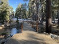 view gallery view galleryE3.4 km |  Round Valley Trail Bridge (West) - Palm Springs, CA Round Valley Trail Bridge (West) - Palm Springs, CA
in Hiking Path Footbridges One of two wooden bridges near the ranger station in Palm Springs, California. posted by: bluesnote location: California date approved: 07/16/2023 last visited: never |
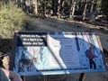 view gallery view galleryE3.4 km |  Animals are Prepared for a Night in the Woods-Are You? - Palm Springs, CA Animals are Prepared for a Night in the Woods-Are You? - Palm Springs, CA
in Flora and Fauna Information Signs A fauna sign at the ranger station in Palm Springs, California. posted by: bluesnote location: California date approved: 07/17/2023 last visited: never |
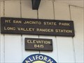 view gallery view galleryE3.4 km |  Palm Springs - 8415 Ft Palm Springs - 8415 Ft
in Elevation Signs A sign at the ranger station at Mount San Jacinto State Park. posted by: saopaulo1 location: California date approved: 09/28/2017 last visited: 05/13/2023 |
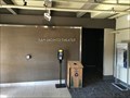
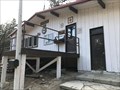 view gallery view galleryE3.4 km |  Mount San Jacinto State Park - Long Valley Ranger Station - Palm Springs, CA Mount San Jacinto State Park - Long Valley Ranger Station - Palm Springs, CA
in Ranger Stations The ranger station is in the Mount San Jacinto State Park. posted by: saopaulo1 location: California date approved: 09/29/2017 last visited: 05/13/2023 |
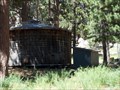 view gallery view galleryE3.5 km |  San Jacinto Wood Water Tank San Jacinto Wood Water Tank
in Water Towers This wooden water tank is in Long Valley in San Jacinto State Park. It likely supplies the nearby ranger station. posted by: TerryDad2 location: California date approved: 08/29/2006 last visited: 05/13/2023 |
 view gallery view galleryE3.5 km | Round Valley Trail Bridge (East) - Palm Springs, CA in Hiking Path Footbridges A bridge on a trail by the Long Valley Ranger Station at Mount San Jacinto State Park. posted by: saopaulo1 location: California date approved: 10/01/2017 last visited: 05/13/2023 |
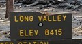 view gallery view galleryE3.5 km | Long Valley, California ~ 8415 ft in Elevation Signs An elevation trail sign in Long Valley, California. posted by: bluesnote location: California date approved: 07/16/2023 last visited: never |
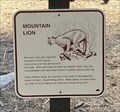 view gallery view galleryE3.5 km | Mountain Lion - Palm Springs, CA in Flora and Fauna Information Signs A fauna sign located at San Jacinto State Park in Palm Springs, California. posted by: bluesnote location: California date approved: 07/17/2023 last visited: never |
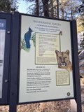 view gallery view galleryE3.5 km | Wilderness Safety - Palm Springs, CA in Flora and Fauna Information Signs A fauna sign located at San Jacinto State Park in Palm Springs, California. posted by: bluesnote location: California date approved: 07/17/2023 last visited: never |
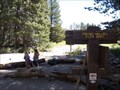
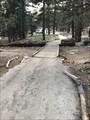
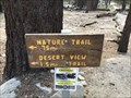 view gallery view galleryE3.5 km |  Nature Trail - Palm Springs, CA Nature Trail - Palm Springs, CA
in Hiking and walking trailheads A small trail in Mount San Jacinto State Park. posted by: saopaulo1 location: California date approved: 10/01/2017 last visited: 05/13/2023 |
 view gallery view galleryE3.7 km |  San Jacinto Theater - Palm Springs, CA San Jacinto Theater - Palm Springs, CA
in Live Stage Theaters A theater at the Mountain Tram Station in Palm Springs, California. posted by: bluesnote location: California date approved: 03/31/2023 last visited: never |
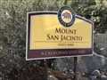 view gallery view galleryE3.7 km |  Mount San Jacinto State Park - Palm Springs, CA Mount San Jacinto State Park - Palm Springs, CA
in Olmsted Designed Parks A large state park in Palm Springs, California. The park was designed by the Olmsted Brothers. posted by: bluesnote location: California date approved: 01/21/2024 last visited: never |
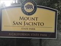 view gallery view galleryE3.7 km |  Mount San Jacinto State Park - Palm Springs, CA Mount San Jacinto State Park - Palm Springs, CA
in State/Provincial Parks The Mount San Jacinto State Park in Palm Springs, CA. posted by: saopaulo1 location: California date approved: 09/28/2017 last visited: 03/31/2023 |
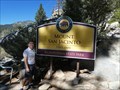 view gallery view galleryE3.7 km |  Mount San Jacinto State Park - Palm Springs, CA Mount San Jacinto State Park - Palm Springs, CA
in Wikipedia Entries Take the Palm Springs Tramway up to the Park's hiking trails. posted by: Metro2 location: California date approved: 09/20/2018 last visited: 03/31/2023 |
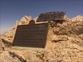
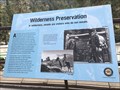 view gallery view galleryE3.7 km |  Wilderness Preservation - Palm Springs, CA Wilderness Preservation - Palm Springs, CA
in Signs of History A plaque at Mount San Jacinto. posted by: saopaulo1 location: California date approved: 09/28/2017 last visited: 11/19/2022 |
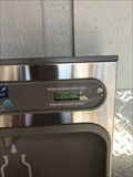 view gallery view galleryE3.7 km |  Counting Display Water Bottles Saved (Mountain Station) - Palm Springs, CA Counting Display Water Bottles Saved (Mountain Station) - Palm Springs, CA
in Counting and Measuring Displays A water bottle refill station inside the Mountain Station at the Palm Springs Aerial Tramway in Palm Springs, California. posted by: bluesnote location: California date approved: 11/19/2022 last visited: never |
|