 view gallery view gallery S5.8 km S5.8 km
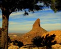
|   Weavers Needle & The Lone Pine Weavers Needle & The Lone Pine
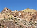
in Scenic Overlooks Weavers Needle and the Superstions posted by:  Tahosa and Sons Tahosa and Sons location: Arizona date approved: 12/02/2011 last visited: 03/11/2014 |
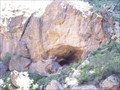
 S6.6 km | ") Geronimo's Cave in Arizona Geronimo's Cave in Arizona
in Cave Entrances (Natural) This is the cave Geronimo reportedly used to escape capture in 1886, here in the Superstition Mountains in Arizona. posted by: [DELETED_USER] location: Arizona date approved: 11/30/2011 last visited: 06/18/2021 |
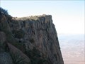
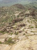 view gallery view galleryS6.9 km | Cave Trail Overlook in Scenic Overlooks This overlook is on the top of the cliff. And the Old USGS Topo Maps show the elevation change and the dotted line is the trail. Navigation to this point goes beyond knowledge of a GPS. Terrain reading skills are tantamount to find this place. posted by: Tahosa and Sons location: Arizona date approved: 12/02/2011 last visited: never |
 view gallery view gallery NW7.1 km NW7.1 km
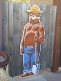
|  Smokey Bear - Tortilla Flat Arizona Smokey Bear - Tortilla Flat Arizona
in Smokey Bear Sign Sightings Smokey bear guards the Tortilla Flat Tonto National Forest office posted by:  sundevil1994 sundevil1994 location: Arizona date approved: 02/13/2011 last visited: 03/21/2020 |
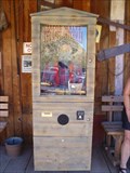 view gallery view galleryNW7.1 km |  Jacob Waltz The Lost Dutchman - Tortilla Flat, Arizona Jacob Waltz The Lost Dutchman - Tortilla Flat, Arizona
in Coin-Operated Fortune Telling Machines For a dollar he'll tell you all posted by: sundevil1994 location: Arizona date approved: 02/13/2011 last visited: 01/13/2023 |
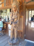 view gallery view galleryNW7.1 km |  Superstition Saloon Large Indian - Tortilla Flat Arizona Superstition Saloon Large Indian - Tortilla Flat Arizona
in Cigar Store Indians 8' Cigar Indian outside of the Superstition Saloon posted by: sundevil1994 location: Arizona date approved: 02/23/2011 last visited: 03/21/2020 |
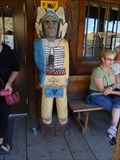 view gallery view galleryNW7.1 km | Superstition Saloon Small Indian - Tortilla Flat Arizona in Cigar Store Indians A painted 6' Cigar Indian outside of the Superstition Saloon posted by: sundevil1994 location: Arizona date approved: 02/12/2011 last visited: 03/21/2020 |
 view gallery view galleryNW7.1 km |  Apachee Trail - Tortilla Flat Arizona Apachee Trail - Tortilla Flat Arizona
in Ancient Traces and Roads This trail was used by the Yavapai tribe to navigate through the Superstition mountains. The name came when settlers came they mistook the Yavapai to be Apache. posted by: sundevil1994 location: Arizona date approved: 10/13/2011 last visited: 07/12/2021 |
 view gallery view gallery NE7.4 km NE7.4 km
|  Fish Creek Canyon Cave Fish Creek Canyon Cave
in Simulacra Don't you think it looks like half of a gigantic head, maybe of the Frankenstein monster? Look at that huge eye socket! posted by: Algoma! location: Arizona date approved: 09/25/2007 last visited: never |
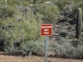
 view gallery view galleryS7.6 km | Cave Trail #233 in Scenic Hikes The old trail that officially doesn't exist. But it is there, and ready to be explored by those that know how to safely plan a route in some awesome backcountry. The distance of this hike is greater than 5 miles with about 5 hours on the trail. posted by: Tahosa and Sons location: Arizona date approved: 12/01/2011 last visited: never |
 view gallery view galleryS8.7 km |  Don's of Arizona Camp Gate Don's of Arizona Camp Gate
in Gates of Distinction A big wrought iron gate at the entrance to The Don's Camp. posted by: Scrawlinn location: Arizona date approved: 03/23/2008 last visited: 03/14/2018 |
 view gallery view gallery W10.9 km W10.9 km
| Flatiron - Superstition Wilderness in Scenic Overlooks Prominent rock outcrop on the western edge of the Superstition Wilderness (often called Superstition Mountain(s)). posted by: =CCC= location: Arizona date approved: 05/21/2008 last visited: 01/19/2014 |
 view gallery view gallery E10.9 km E10.9 km
|  Labarge Mountain Labarge Mountain
in Mountain Summits LaBarge Mountain is trail-less summit in the Superstition Wilderness. posted by: John's GPS location: Arizona date approved: 09/22/2006 last visited: never |
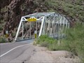 view gallery view galleryNW11.4 km |  Apache Trail Truss Bridge - Tonto National Forest, Arizona Apache Trail Truss Bridge - Tonto National Forest, Arizona
in Truss Bridges This truss bridge carries State Route 88 over an arm of Canyon Lake on the Salt River in Maricopa County, Arizona. posted by: rjmcdonough1 location: Arizona date approved: 10/16/2015 last visited: 03/21/2020 |
 view gallery view gallery SW11.4 km SW11.4 km
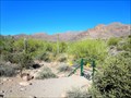
|  Lost Goldmine Trail - Gold Canyon, AZ Lost Goldmine Trail - Gold Canyon, AZ
in Hiking and walking trailheads This is the trailhead for several trails wandering through the Superstition Mounts. posted by: rjmcdonough1 location: Arizona date approved: 02/04/2018 last visited: never |
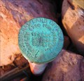
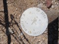
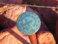 view gallery view gallerySW11.6 km |  U.S. General Land Office Survey Marker 1924 - Gold Canyon, AZ U.S. General Land Office Survey Marker 1924 - Gold Canyon, AZ
in U.S. Benchmarks This marker is located on State Trust Land just outside of Gold Canyon, Arizona. posted by: rjmcdonough1 location: Arizona date approved: 11/23/2017 last visited: never |
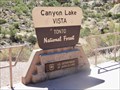 view gallery view galleryNW12.1 km |  Canyon Lake Vista - Maricopa County, AZ Canyon Lake Vista - Maricopa County, AZ
in Scenic Roadside Look-Outs Canyon Lake Vista - Arizona posted by: ToRo61 location: Arizona date approved: 11/01/2017 last visited: 03/21/2020 |
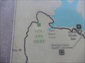 view gallery view galleryNW12.1 km |  You Are Here - Canyon Lake Vista, AZ You Are Here - Canyon Lake Vista, AZ
in 'You Are Here' Maps You Are Here - Canyon Lake Vista posted by: ToRo61 location: Arizona date approved: 10/30/2017 last visited: 03/21/2020 |
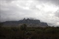 view gallery view galleryW12.1 km |  Superstition Mountains -- nr Apache Junction AZ Superstition Mountains -- nr Apache Junction AZ
in Vortexes, Mystery Spots, and Gravity Hills The Superstition Mountains are well known as a source of many mysterious energy vortices. posted by: Benchmark Blasterz location: Arizona date approved: 02/21/2014 last visited: 03/27/2023 |
 view gallery view galleryW12.1 km |  Superstition Mountain Bike Trail - Apache Junction, AZ Superstition Mountain Bike Trail - Apache Junction, AZ
in Mountain Bike Trailheads A 9 mile trail at the foot of the beautiful Superstition Mountains in Lost Dutchman State Park posted by: dkestrel location: Arizona date approved: 02/07/2014 last visited: 02/01/2014 |
 view gallery view gallerySW12.2 km | U.S. General Land Office Survey Marker T1N 9 RE 1924 - Gold Canyon, AZ in U.S. Benchmarks This marker is located on State Trust Land at an intersection with National Forest Land just outside of Gold Canyon, Arizona. posted by: rjmcdonough1 location: Arizona date approved: 11/23/2017 last visited: never |
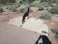 view gallery view galleryW12.2 km |  Coyote Sundial in Superstition Mountain State Park - Apache Junction Arizona Coyote Sundial in Superstition Mountain State Park - Apache Junction Arizona
in Sundials This sundial uses an iron cutout of a coyote as the pointer on the dial. posted by: rjmcdonough1 location: Arizona date approved: 10/12/2014 last visited: 04/13/2018 |
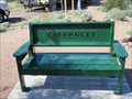
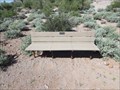 view gallery view galleryW12.2 km |  Jack and Betty Gerard Bench - Apache Junction Arizona Jack and Betty Gerard Bench - Apache Junction Arizona
in Dedicated Benches This bench is dedicated to Jack and Betty Gerard and is located on the discovery trail in the Superstition Mountain State Park in Apache Junction Arizona. posted by: rjmcdonough1 location: Arizona date approved: 10/12/2014 last visited: 03/18/2016 |
 view gallery view galleryW12.2 km | Paul Ponzetti, Jr. Memorial Bench - Apache Junction Arizona in Dedicated Benches This bench, located in the Superstition Mountain State Park, honors Paul Ponzetti, Jr. posted by: rjmcdonough1 location: Arizona date approved: 10/12/2014 last visited: never |
 view gallery view galleryW13 km | Mineral Survey Marker 3886 - Apache Junction, AZ in U.S. Benchmarks This pipe cap marker indicates the corner of a mineral survey claim. posted by: rjmcdonough1 location: Arizona date approved: 06/06/2016 last visited: 12/18/2016 |
|