 view gallery view gallery S0.3 km S0.3 km
|   Mogollon Mogollon
in New Mexico Historical Markers The name, Mogollon, prominent in the topography and history of the southwest, is attached to both the mountains and a ghost town in this area of New Mexico. posted by:  linkys linkys location: New Mexico date approved: 12/17/2009 last visited: 01/24/2015 |
 view gallery view gallery N3.9 km N3.9 km
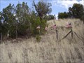
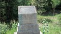
|  W.S. Ranch Cemetery W.S. Ranch Cemetery
in Abandoned Cemeteries Located just outside of Alma, NM. Alma is north of Silver City, NM. posted by:  beagle39z beagle39z location: New Mexico date approved: 04/10/2007 last visited: never |
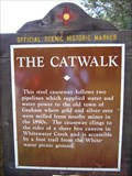 view gallery view galleryS5.3 km | The Catwalk in New Mexico Historical Markers A New Mexico OSHM near Glenwood on US-180. posted by: leadhiker location: New Mexico date approved: 06/07/2011 last visited: never |
 view gallery view galleryS6.4 km |  Glenwood Ranger Station - Gila National Forest Glenwood Ranger Station - Gila National Forest
in Ranger Stations US Forest Service Ranger District in southwestern New Mexico that includes the Catwalk National Recreation Area. posted by: linkys location: New Mexico date approved: 03/31/2008 last visited: never |
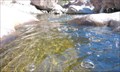
 view gallery view gallery E6.8 km E6.8 km
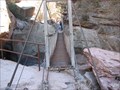
|  Whitewater Creek - Glenwood, New Mexico Whitewater Creek - Glenwood, New Mexico
in Pedestrian Suspension Bridges Old pedestrian suspension bridge spanning Whitewater Creek at the upper end of the Catwalk National Recreation Trail. posted by: linkys location: New Mexico date approved: 04/06/2008 last visited: 05/18/2011 |
 view gallery view gallery SW31.9 km SW31.9 km
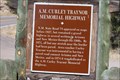
| A. M. Curley Traynor Memorial Highway - Mule Creek, NM in New Mexico Historical Markers New Mexico Historical Marker commemorating local rancher A. M. Curley Traynor and N.M./Az. Highway 78. posted by: outwest63 location: New Mexico date approved: 06/09/2014 last visited: never |
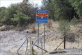 view gallery view gallerySW32 km |  AZ/NM Hwy 78 AZ/NM Hwy 78
in Border Crossings Az./N.M. border crossing on Highway 78 posted by: outwest63 location: Arizona date approved: 06/09/2014 last visited: never |
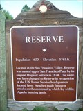 view gallery view galleryN36.4 km | Reserve in New Mexico Historical Markers There are two OSHM's for Reserve. The other one is about 6 miles east. posted by: leadhiker location: New Mexico date approved: 06/07/2011 last visited: 07/02/2012 |
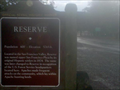 view gallery view galleryN40.7 km | Reserve OSHM in New Mexico Historical Markers OSHM sign for Reserve,NM posted by: kingbee location: New Mexico date approved: 08/19/2010 last visited: 07/02/2012 |
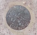
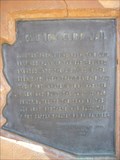
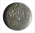 view gallery view galleryN40.9 km |  US BUREAU OF PUBLIC ROADS 5764.34 9 US BUREAU OF PUBLIC ROADS 5764.34 9
in U.S. Benchmarks US BUREAU OF PUBLIC ROADS BM 5764.34 9 posted by: GEO*Trailblazer 1 location: New Mexico date approved: 01/01/2007 last visited: 01/01/2007 |
 view gallery view gallery SE46.5 km SE46.5 km
|  TURKEY CREEK HOT SPRINGS TURKEY CREEK HOT SPRINGS
in Hot Springs TURKEY CREEK HOT SPRINGS GILA WILDERNESS posted by: GEO*Trailblazer 1 location: New Mexico date approved: 11/14/2006 last visited: 10/09/2009 |
 view gallery view gallery NW47.5 km NW47.5 km
| Blue Vista Benchmark (Y 69) - DT0238 in U.S. Benchmarks Located in Blue Vista rest area on US191. posted by: Brad&Kim location: Arizona date approved: 09/08/2012 last visited: 05/21/2017 |
 view gallery view galleryNW49.7 km |  Clifton-Springerville Highway Marker - Coronado Trail Scenic Byway - Arizona Clifton-Springerville Highway Marker - Coronado Trail Scenic Byway - Arizona
in National Scenic Byways An historical marker commemorating the construction of the Clifton-Springerville Highway in 1926. This marker is along the Coronado Trail Scenic Byway. posted by: adenium location: Arizona date approved: 07/08/2012 last visited: 05/19/2022 |
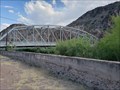
 view gallery view gallerySW50.7 km |  Park Avenue Bridge - Clifton, Arizona Park Avenue Bridge - Clifton, Arizona
in Wikipedia Entries Park Avenue Bridge is a through truss bridge over the San Francisco River in Clifton. posted by: rjmcdonough1 location: Arizona date approved: 06/15/2022 last visited: 05/21/2017 |
 view gallery view gallerySW50.7 km |  Park Avenue Bridge - Clifton, AZ Park Avenue Bridge - Clifton, AZ
in U.S. National Register of Historic Places Park Avenue Bridge is a through truss bridge over the San Francisco River in Clifton. posted by: rjmcdonough1 location: Arizona date approved: 06/19/2022 last visited: 05/21/2017 |
 view gallery view gallerySW50.7 km |  Park Avenue Bridge - Clifton, AZ Park Avenue Bridge - Clifton, AZ
in Truss Bridges Park Avenue Bridge is a through truss bridge over the San Francisco River in Clifton. posted by: rjmcdonough1 location: Arizona date approved: 06/15/2022 last visited: 05/21/2017 |
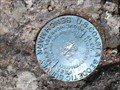
 view gallery view gallerySW50.7 km | ACC5 (DT0353) - Clifton, AZ in U.S. Benchmarks This U.S. Benchmark is set at the west end of the Park Avenue Truss Bridge - in Clifton, Arizona. posted by: The Snowdog location: Arizona date approved: 04/15/2024 last visited: never |
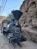 view gallery view gallerySW50.7 km |  Coronado Railroad No. 8 - Clifton, AZ Coronado Railroad No. 8 - Clifton, AZ
in Locomotives Engine No. 8, nicknamed Copper Head, is a 20-gauge steam engine. posted by: rjmcdonough1 location: Arizona date approved: 06/15/2022 last visited: never |
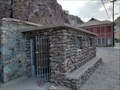 view gallery view gallerySW50.7 km |  Clifton Cliff Jail - Clifton, AZ Clifton Cliff Jail - Clifton, AZ
in Retired Prisons Clifton's first jail was blasted from solid rock by the miner who was the first inmate. posted by: rjmcdonough1 location: Arizona date approved: 06/14/2022 last visited: never |
 view gallery view gallerySW50.9 km |  Clifton Cliff Jail Clifton Cliff Jail
in Arizona Historical Markers 1880's Arizona Law and Order. posted by: leadhiker location: Arizona date approved: 06/07/2011 last visited: 06/12/2022 |
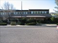
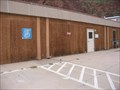 view gallery view gallerySW50.9 km |  Clifton Town Library Clifton Town Library
in Libraries Books, Books on Tape, CDs, VHS and DVD movies. posted by: Me & Bucky location: Arizona date approved: 08/19/2005 last visited: 06/01/2019 |
 view gallery view gallerySW51 km |  1907 - Jim Sing's Chophouse, Clifton AZ 1907 - Jim Sing's Chophouse, Clifton AZ
in Dated Buildings and Cornerstones Jim Sing's Chop House was constructed in 1907 and retains its original signage on the front. posted by: rjmcdonough1 location: Arizona date approved: 06/13/2022 last visited: never |
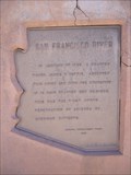 view gallery view gallerySW51 km | San Francisco River in Arizona Historical Markers In January, 1825 on a river they called St. Francisco, they caught 250 beavers over the next couple of weeks posted by: leadhiker location: Arizona date approved: 06/07/2011 last visited: never |
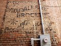 view gallery view gallerySW51 km |  Wholesale and Retail Groceries - Clifton, AZ Wholesale and Retail Groceries - Clifton, AZ
in Ghost Signs This sign is on the side of the Cascarelli building which was constructed in 1913. posted by: rjmcdonough1 location: Arizona date approved: 06/14/2022 last visited: never |
 view gallery view gallerySW51 km | 1913 - The Cascarelli Building Clifton, AZ in Dated Buildings and Cornerstones Built in 1913, after a devastating fire raged through town, this building replaced a former three-story structure. posted by: rjmcdonough1 location: Arizona date approved: 06/13/2022 last visited: never |
|