 view gallery view gallery NW1.9 km NW1.9 km
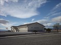
|   Kingdom Hall of Jehovah's Witnesses - Salton City CA Kingdom Hall of Jehovah's Witnesses - Salton City CA
in Kingdom Halls of Jehovah's Witnesses This Kingdom Hall of Jehovah's Witnesses is on South Riviera Circle just west of Marshall Avenue in Salton City, California. posted by:  PeterNoG PeterNoG location: California date approved: 01/11/2013 last visited: 01/10/2013 |
 view gallery view galleryNW2.7 km |  Thermal, California 92274 ~ West Shores Market CPU (Salton City Branch) Thermal, California 92274 ~ West Shores Market CPU (Salton City Branch)
in U.S. Post Offices This Post Office is located at 2113 S Marina Drive in Salton City, California. posted by: brwhiz location: California date approved: 10/03/2013 last visited: never |
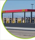 view gallery view galleryNW2.9 km |  Salton City AM/PM featuring Pearson Fuels E85 Ethanol Salton City AM/PM featuring Pearson Fuels E85 Ethanol
in E85 Fuel Pumps This large truck stop is newly constructed and is billed as the "Largest ARCO in California." posted by:  Pearson Fuels Pearson Fuels location: California date approved: 09/18/2009 last visited: 02/12/2018 |
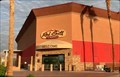
 view gallery view galleryNW2.9 km |  Jack in the Box - Salton Sea, CA Jack in the Box - Salton Sea, CA
in Jack In The Box A Jack in the Box in Salton Sea, CA. posted by: saopaulo1 location: California date approved: 09/30/2017 last visited: never |
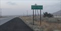
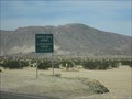
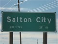 view gallery view galleryNW6.6 km |  Salton City CA - Population: 3,763 Salton City CA - Population: 3,763
in Population Signs This Population/Elevation Sign is on California Highway 86 on the north side of Salton City, California. posted by: PeterNoG location: California date approved: 01/12/2013 last visited: 01/10/2013 |
 view gallery view galleryNW6.6 km |  Salton City CA - Elevation: 100 feet below sea level Salton City CA - Elevation: 100 feet below sea level
in Elevation Signs This Elevation/Population Sign is on California Highway 86 on the north side of Salton City, California. posted by: PeterNoG location: California date approved: 01/11/2013 last visited: 01/10/2013 |
 view gallery view galleryNW12.4 km |  Red Earth Casino - Thermal, CA Red Earth Casino - Thermal, CA
in Casinos A casino in Thermal, CA. posted by: saopaulo1 location: California date approved: 03/11/2020 last visited: never |
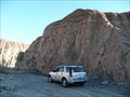 view gallery view gallery W14 km W14 km
|  Truckhaven Trail - Anza-Borrego Desert State Park- CA Truckhaven Trail - Anza-Borrego Desert State Park- CA
in Offroad Trails Although a paved road (the Borrego Salton Seaway) follows the original Truckhaven Trail fairly closely, there are still many portions of the old trail can still be seen. posted by: PeterNoG location: California date approved: 03/31/2008 last visited: 01/11/2008 |
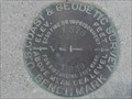
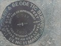 view gallery view gallery S14.6 km S14.6 km
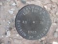
|  DW0306: C 579 - Imperial County CA DW0306: C 579 - Imperial County CA
in U.S. Benchmarks This Benchmark is on the north side of Calif Hwy 78 about 5.2 miles west of Calif Hwy 86 in Imperial County, California. posted by: PeterNoG location: California date approved: 09/05/2013 last visited: 04/01/2009 |
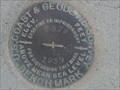
 view gallery view galleryS14.8 km | DW0308: D 579 - Imperial County CA in U.S. Benchmarks This Benchmark is on the south side of Calif Hwy 78 about 6.2 miles west of Calif Hwy 86 in Imperial County, California. posted by: PeterNoG location: California date approved: 09/05/2013 last visited: 04/01/2009 |
 view gallery view galleryS14.8 km | DW0304: B 579 - Imperial County CA in U.S. Benchmarks This Benchmark is on the south side of Calif Hwy 78 about 4.2 miles west of Calif Hwy 86 in Imperial County, California. posted by: PeterNoG location: California date approved: 09/05/2013 last visited: 04/01/2009 |
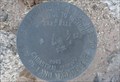
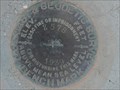
 view gallery view galleryS15 km | IMP 198 A AS 96 - Imperial County CA in U.S. Benchmarks This disk is 20 meters north of Hwy 78 and 5.9 kilometers west of Hwy 86. posted by: PeterNoG location: California date approved: 06/29/2009 last visited: 04/01/2009 |
 view gallery view galleryS15.1 km | DW0303: A 579 - Imperial County CA in U.S. Benchmarks This Benchmark is on the south side of Calif Hwy 78 about 3.2 miles west of Calif Hwy 86 in Imperial County, California. posted by: PeterNoG location: California date approved: 09/05/2013 last visited: 04/01/2009 |
 view gallery view galleryS15.6 km | DW0302: Y 578 - Imperial County CA in U.S. Benchmarks This Benchmark is on the south side of Calif Hwy 78 about 2.1 miles west of Calif Hwy 86 in Imperial County, California. posted by: PeterNoG location: California date approved: 09/05/2013 last visited: 04/01/2009 |
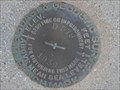
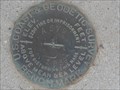
 view gallery view gallery SE16.3 km SE16.3 km
| T12S R11E 1/4 S18 - Imperial County CA in U.S. Benchmarks This cadastral survey disk is 23 meters (75 feet) west of benchmark DW0241 (Z 578). posted by: PeterNoG location: California date approved: 06/29/2009 last visited: 04/01/2009 |
 view gallery view gallerySE16.3 km | DW0241: Z 578 - Imperial County CA in U.S. Benchmarks This Benchmark is on the south side of Calif Hwy 78 about 1.1 miles west of Calif Hwy 86 in Imperial County, California. posted by: PeterNoG location: California date approved: 09/05/2013 last visited: 04/01/2009 |
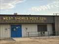 view gallery view galleryNW18.7 km |  Post 3251 West Shores Post- Desert Shores, CA Post 3251 West Shores Post- Desert Shores, CA
in VFW Posts A VFW post in Desert Shores, CA. posted by: saopaulo1 location: California date approved: 03/29/2020 last visited: never |
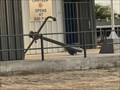 view gallery view galleryNW18.7 km |  West Shores Post Anchor - Desert Shores, CA West Shores Post Anchor - Desert Shores, CA
in Anchors An anchor in front of a VFW hall in West Shores, CA. posted by: saopaulo1 location: California date approved: 03/12/2020 last visited: never |
 view gallery view galleryNW19.5 km | Desert Shores, CA - POP 1104 in Population Signs A sign on Hway 111 in Desert Shores, CA. posted by: saopaulo1 location: California date approved: 10/02/2017 last visited: never |
 view gallery view galleryNW19.5 km | Desert Shores, CA - 190 Ft in Elevation Signs A sign on Hway 111 in Desert Shores, CA. posted by: saopaulo1 location: California date approved: 10/01/2017 last visited: never |
 view gallery view gallery SW19.6 km SW19.6 km
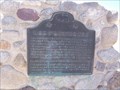
|  Fages-De Anza Trail-Southern Emigrant Road Fages-De Anza Trail-Southern Emigrant Road
in California Historical Markers This marker lies along the trail used by Anza as he traveled up to found San Francisco. posted by: TerryDad2 location: California date approved: 10/24/2006 last visited: 01/18/2014 |
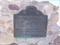 view gallery view gallerySW19.6 km |  Fages-De Anza Trail-Southern Emigrant Road Fages-De Anza Trail-Southern Emigrant Road
in U.S. National Register of Historic Places This marker lies along the trail used by Anza as he traveled up to found San Francisco. posted by: TerryDad2 location: California date approved: 10/24/2006 last visited: 12/16/2013 |
 view gallery view gallerySW20.9 km |  Ocotillo Wells Airport - Ocotillo Wells, CA Ocotillo Wells Airport - Ocotillo Wells, CA
in Airports This airport is near the small city of Octillo Wells. posted by: bluesnote location: California date approved: 01/25/2011 last visited: 12/24/2013 |
 view gallery view gallerySW20.9 km |  Ocotillo Wells Airport - Ocotillo Wells, CA Ocotillo Wells Airport - Ocotillo Wells, CA
in Wikipedia Entries This airport is near the small city of Octillo Wells. posted by: bluesnote location: California date approved: 12/24/2013 last visited: 12/24/2013 |
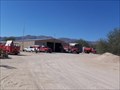 view gallery view gallerySW21.9 km |  Ocotillo Wells Fire Department Ocotillo Wells Fire Department
in Firehouses The Ocotillo Wells Fire department. Serving the off-roading community in Ocotillo Wells. posted by: TerryDad2 location: California date approved: 10/23/2006 last visited: 12/11/2009 |
|