 view gallery view gallery W1.4 km W1.4 km
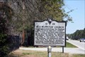
|   Old Wappetaw Church 10-29 - Awendaw, SC Old Wappetaw Church 10-29 - Awendaw, SC
in South Carolina Historical Markers Located on Ocean Highway (U.S. 17) 0.1 miles north of Fifteen Mile Landing Road (South Carolina Route 10-584), Awendaw, SC. posted by:  Lat34North Lat34North location: South Carolina date approved: 04/10/2011 last visited: 03/24/2011 |
 view gallery view gallery NE6.3 km NE6.3 km
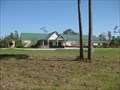
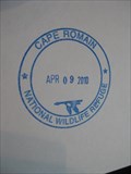
|  Cape Romain National Wildlife Refuge - SC Cape Romain National Wildlife Refuge - SC
in National Wildlife Refuges A large tract of land set aside to protect migratory birds and sea turtles. posted by:  ChapterhouseInc ChapterhouseInc location: South Carolina date approved: 05/04/2010 last visited: 04/09/2010 |
 view gallery view galleryNE6.3 km |  Cape Romain National Wildlife Refuge Cape Romain National Wildlife Refuge
in Wikipedia Entries A large tract of land set aside to protect migratory birds and sea turtles. posted by: ChapterhouseInc location: South Carolina date approved: 05/01/2010 last visited: 04/09/2010 |
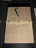 view gallery view galleryNE6.3 km |  Sewee Visitor Center Guest Book - Cape Romain NWR Sewee Visitor Center Guest Book - Cape Romain NWR
in Guest Books A large tract of land set aside to protect migratory birds and sea turtles. posted by: ChapterhouseInc location: South Carolina date approved: 05/01/2010 last visited: 04/09/2010 |
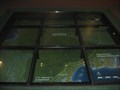 view gallery view galleryNE6.3 km |  The Sewee Visitor Center at Cape Romain NWR is where you are The Sewee Visitor Center at Cape Romain NWR is where you are
in 'You Are Here' Maps Set in the floor, this large map of the surrounding area notates where you are in relation to other destinations. posted by: ChapterhouseInc location: South Carolina date approved: 05/01/2010 last visited: 04/09/2010 |
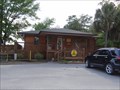
 view gallery view galleryNE6.3 km |  Sewee Visitor Center - Francis Marion National Forest Sewee Visitor Center - Francis Marion National Forest
in National Public Lands Passport Locations This National Forest Visitor and Environmental Education Center has a passport stamp. posted by: ChapterhouseInc location: South Carolina date approved: 05/26/2010 last visited: 04/09/2010 |
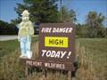 view gallery view galleryNE6.3 km |  Sewee Visitor Center Smokey Bear Sewee Visitor Center Smokey Bear
in Smokey Bear Sign Sightings This Smokey advises those traveling north on US 17 the fire danger in the Francis Marion National Forest. posted by: ChapterhouseInc location: South Carolina date approved: 04/15/2010 last visited: 04/09/2010 |
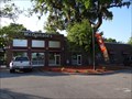
 view gallery view galleryNE7.4 km |  Awendaw, SC 29429 Awendaw, SC 29429
in U.S. Post Offices Post Office, Awendaw, SC. posted by: carolina1 location: South Carolina date approved: 08/24/2007 last visited: 04/09/2010 |
 view gallery view gallery SW9.8 km SW9.8 km
|  KOA Campground-Mt Pleasant, SC 29466 KOA Campground-Mt Pleasant, SC 29466
in Campgrounds KOA Campground-3157 Highway 17 N., Mt. Pleasant, SC 29466 posted by: walkingwildly location: South Carolina date approved: 04/26/2014 last visited: 04/29/2014 |
 view gallery view gallerySW10.5 km |  McDonalds-3060 Iron Clad Alleyluff Road-Mt Pleasant, SC McDonalds-3060 Iron Clad Alleyluff Road-Mt Pleasant, SC
in McDonald's Restaurants McDonald's Restaurant-3060 Iron Clad Alleyluff Rd.,Mt Pleasant, SC posted by: walkingwildly location: South Carolina date approved: 04/25/2014 last visited: 05/19/2014 |
 view gallery view gallerySW11.7 km |  Wando Wash - Mt. Pleasant, SC Wando Wash - Mt. Pleasant, SC
in Coin Operated Self Service Car Washes Wando Wash is located in Mt. Pleasant, SC. posted by: carolina1 location: South Carolina date approved: 11/28/2008 last visited: 11/29/2008 |
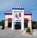 view gallery view gallerySW11.7 km |  KFC - Highway 41 - Mount Pleasant, SC KFC - Highway 41 - Mount Pleasant, SC
in Kentucky Fried Chicken/KFC Restaurants KFC is located on Highway 41 in Mt. Pleasant, SC. posted by: carolina1 location: South Carolina date approved: 09/02/2008 last visited: 09/03/2008 |
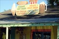 view gallery view gallerySW11.7 km |  Jack's Cosmic Dogs - Mt. Pleasant, SC Jack's Cosmic Dogs - Mt. Pleasant, SC
in Independent Hot Dog Restaurants Jack’s Cosmic Dogs is located on Hwy 17 N in Mt. Pleasant, SC. posted by: carolina1 location: South Carolina date approved: 09/02/2008 last visited: 09/02/2008 |
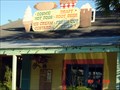 view gallery view gallerySW11.9 km |  Jack's Cosmic Dog - Mt. Pleasant, SC Jack's Cosmic Dog - Mt. Pleasant, SC
in Independent Diners Jack's Cosmic Dogs. posted by: carolina1 location: South Carolina date approved: 08/26/2007 last visited: 08/27/2007 |
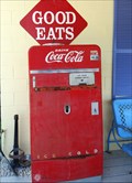 view gallery view gallerySW11.9 km |  Coca Cola Machine - Mt Pleasant, SC Coca Cola Machine - Mt Pleasant, SC
in Coca Cola Memorabilia This coca cola machine is located outside of Jack's Cosmic
Dogs in Mt. Pleasant, SC. posted by: carolina1 location: South Carolina date approved: 09/02/2008 last visited: 09/02/2008 |
 view gallery view gallerySW12.1 km |  Wando Wash Wando Wash
in Self Serve Pet Wash Self Serve Dog Wash. posted by: carolina1 location: South Carolina date approved: 07/29/2007 last visited: 07/30/2007 |
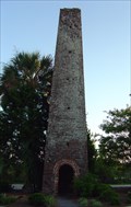 view gallery view gallerySW12.2 km |  Brickyard Plantation - Mt. Pleasant, SC Brickyard Plantation - Mt. Pleasant, SC
in Ovens and Kilns The brick kiln is at Brickyard Plantation in Mt. Pleasan, SC. It was used to make bricks. posted by: carolina1 location: South Carolina date approved: 09/14/2008 last visited: 09/15/2008 |
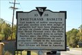 view gallery view gallerySW12.2 km | 10-28 Sweetgrass Baskets in South Carolina Historical Markers Located on Hwy 17 North of Mt. Pleasant, South Carolina. Erected by the Original Sweetgrass Market Place Coalition and the Christ Church Parish Preservation Society-1997. posted by:  mikemtn mikemtn location: South Carolina date approved: 10/22/2006 last visited: 05/22/2014 |
 view gallery view gallerySW13.7 km |  Butterfly House - Mt. Pleasant, SC Butterfly House - Mt. Pleasant, SC
in Butterfly Houses Butterfly House in Mt. Pleasant, South Carolina. posted by: carolina1 location: South Carolina date approved: 07/08/2007 last visited: 06/24/2012 |
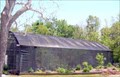
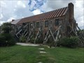 view gallery view gallerySW13.7 km |  Ginhouse - Boone Hall Plantation House and Historic Landscape - Mount Pleasant, SC Ginhouse - Boone Hall Plantation House and Historic Landscape - Mount Pleasant, SC
in NRHP Historic Districts - Contributing Buildings Site # 3, and braced heavily to preserve it. posted by: YoSam. location: South Carolina date approved: 04/11/2018 last visited: never |
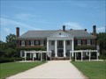 view gallery view gallerySW13.7 km |  Boone Hall Plantation House and Historic Landscape - Mt. Pleasant, SC Boone Hall Plantation House and Historic Landscape - Mt. Pleasant, SC
in U.S. National Register of Historic Places This plantation house was built in 1933 in the Colonial Revival style. posted by: redhead3434 location: South Carolina date approved: 07/19/2010 last visited: 04/10/2018 |
 view gallery view gallerySW13.7 km | Boone Hall - Mount Pleasant, SC in Wikipedia Entries This is actually a historic district and a large plantation, not just a home. posted by: YoSam. location: South Carolina date approved: 04/10/2018 last visited: never |
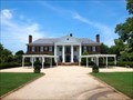
 view gallery view gallerySW13.7 km | Plantation House and Grounds - Boone Hall Plantation House and Historic Landscape - Mount Pleasant, SC in NRHP Historic Districts - Contributing Buildings Right at the end of the long Oak Driveway - site #2 on the NRHP Map posted by: YoSam. location: South Carolina date approved: 04/11/2018 last visited: never |
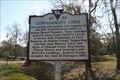 view gallery view gallerySW13.8 km | Confederate Lines 10-39 - Mount Pleasant, SC in South Carolina Historical Markers The Confederate Lines historic marker is located on Old Georgetown Rd east of US 17, Mount Pleasant, SC. posted by: Lat34North location: South Carolina date approved: 03/22/2011 last visited: 04/19/2014 |
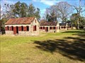 view gallery view gallerySW13.8 km |  Slave Houses - Boone Hall Plantation - Mount Pleasant, SC Slave Houses - Boone Hall Plantation - Mount Pleasant, SC
in Civil Rights Memorials This is a historic district, and operating museum site, cost to enter. posted by: YoSam. location: South Carolina date approved: 04/14/2018 last visited: never |
|