 view gallery view gallery W0 km W0 km
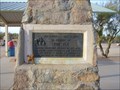
|   In Memory of Tom Mix In Memory of Tom Mix
in Arizona Historical Markers In Memory of
Tom Mix
Whose spirit left his body on this spot.
And whose characterization and portrayals
in life served to better fix memories of
the old west in the minds of living men. posted by:  leadhiker leadhiker location: Arizona date approved: 04/30/2010 last visited: 03/14/2019 |
 view gallery view gallery NW9.5 km NW9.5 km
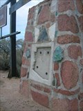
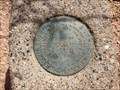
|  Pinal Pioneer Parkway Marker - Florence, AZ Pinal Pioneer Parkway Marker - Florence, AZ
in U.S. Benchmarks This marker is at the base of the sign identifying the Pinal Pioneer Parkway, Hwy.79, south of Florence Arizona. posted by:  rjmcdonough1 rjmcdonough1 location: Arizona date approved: 03/28/2018 last visited: never |
 view gallery view galleryNW9.7 km | Pinal County Welcome - North in Arizona Historical Markers A missing marker, just north of the other Pinal county missing marker, but I believe it's important to document the missing markers. Maybe someone in the Pinal Historical Commission or Arizona Historical Society will take notice. posted by: unimoggers location: Arizona date approved: 10/05/2007 last visited: 10/21/2018 |
 view gallery view gallery S10.5 km S10.5 km
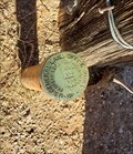
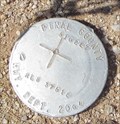
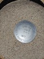
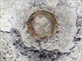
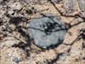
| T8S R 11 E S 17 S16 S 220 S 21 - Red Rock, AZ in U.S. Benchmarks This pipe cap benchmark is located at the gate to a cattle corral. posted by: rjmcdonough1 location: Arizona date approved: 01/01/2024 last visited: never |
 view gallery view gallery SW11.6 km SW11.6 km
| BM 1919 - Red Rock, AZ in U.S. Benchmarks This pipe cap marker is in good shape and sits beside an old ranch road. posted by: rjmcdonough1 location: Arizona date approved: 12/13/2023 last visited: never |
 NW12.2 km |  St Anthony's Greek Orthodox Monastery St Anthony's Greek Orthodox Monastery
in Abbeys, Convents and Monasteries Only a few years old, this monastery is in the middle of the Sonoran Desert in Arizona. posted by:  Tsegi Mike and Desert Viking Tsegi Mike and Desert Viking location: Arizona date approved: 09/15/2005 last visited: 01/20/2010 |
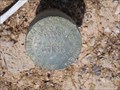
 view gallery view galleryNW17.4 km | Pinal County 510227 - Florence, AZ in U.S. Benchmarks This marker is on the western side of Highway 79 South of Florence, Arizona. posted by: rjmcdonough1 location: Arizona date approved: 09/03/2017 last visited: 03/25/2021 |
 view gallery view gallery N17.9 km N17.9 km
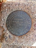
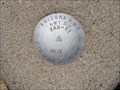
| USGS 3DM 1963 Benchmark in U.S. Benchmarks USGS 3DM 1963 Benchmark Elevation 2344 Feet Above Sea posted by: tincanbits location: Arizona date approved: 09/15/2013 last visited: 06/05/2017 |
 view gallery view galleryN18.2 km | USGS 5DM 1963 Benchmark in U.S. Benchmarks USGS 5DM 1963 Benchmark Elevation 2672 Feet Above Sea posted by: tincanbits location: Arizona date approved: 09/20/2013 last visited: 02/08/2014 |
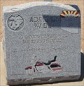 view gallery view galleryNW20.8 km |  Adam G Wade - Florence, AZ Adam G Wade - Florence, AZ
in Citizen Memorials This memorial marker honoring Adam G. Wade sits on the East side of State Highway 79 South of Florence, Arizona. posted by: rjmcdonough1 location: Arizona date approved: 09/06/2017 last visited: 02/28/2021 |
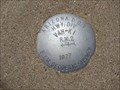
 view gallery view galleryNW22.4 km | VAH KI Marker R.M. 1 - Florence, AZ in U.S. Benchmarks This is the Southernmost of a group of three markers alongside Hwy. 79, south of Florence, Arizona. posted by: rjmcdonough1 location: Arizona date approved: 08/20/2017 last visited: never |
 view gallery view galleryNW22.4 km | VAH KI Control Marker - Florence, AZ in U.S. Benchmarks VAH KI is the center of three markers located south of Florence, Arizona. posted by: rjmcdonough1 location: Arizona date approved: 08/20/2017 last visited: 02/27/2021 |
 view gallery view galleryNW22.4 km | VAH KI Marker R.M. 2 - Florence, AZ in U.S. Benchmarks This is the Northernmost of a group of three markers alongside Hwy. 79, south of Florence, Arizona. posted by: rjmcdonough1 location: Arizona date approved: 08/20/2017 last visited: never |
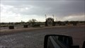
 view gallery view galleryNW23.2 km |  Stop For Canopy Traffic, Coolidge Airport - Coolidge, AZ Stop For Canopy Traffic, Coolidge Airport - Coolidge, AZ
in Unusual Signs This stop sign warns drivers of an unusual airport hazard at the Coolidge Airport. posted by: rjmcdonough1 location: Arizona date approved: 04/01/2018 last visited: 07/22/2018 |
 view gallery view galleryNW23.5 km |  Florence RC Model Airpark - Florence, AZ Florence RC Model Airpark - Florence, AZ
in Model Aircraft Fields This model RC airpark is two miles south of Florence, Arizona on Hwy 79. posted by: rjmcdonough1 location: Arizona date approved: 08/23/2017 last visited: 10/21/2018 |
 view gallery view galleryNW24.1 km |  Coolidge Municipal Airport - Coolidge, AZ Coolidge Municipal Airport - Coolidge, AZ
in Airports Coolidge Municipal Airport began as an Army Airfield in 1941. posted by: rjmcdonough1 location: Arizona date approved: 04/02/2018 last visited: 07/22/2018 |
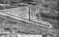 view gallery view galleryNW24.1 km |  Coolidge Municipal Airport - Coolidge, AZ Coolidge Municipal Airport - Coolidge, AZ
in Photos Then and Now Coolidge Municipal Airport began as an Army Airfield in 1941. posted by: rjmcdonough1 location: Arizona date approved: 04/03/2018 last visited: 07/22/2018 |
 view gallery view galleryNW24.1 km |  Coolidge Municipal Airport - Coolidge, AZ Coolidge Municipal Airport - Coolidge, AZ
in Wikipedia Entries Coolidge Municipal Airport began as an Army Airfield in 1941. posted by: rjmcdonough1 location: Arizona date approved: 03/31/2018 last visited: 07/22/2018 |
 view gallery view galleryNW24.5 km | US General Land Survey 1961 Dogwood Rd in U.S. Benchmarks US General Land Survey 1961 Dogwood Rd posted by: tincanbits location: Arizona date approved: 09/15/2013 last visited: never |
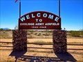
 view gallery view galleryNW24.6 km |  Welcome to Coolidge Army Airfield sign Welcome to Coolidge Army Airfield sign
in World War II Sites Coolidge AAF had originally been designed by the War Department as a single-engine aircraft flight training school, however, the facility initially functioned as an auxiliary field for Williams AAF as Williams Auxiliary Field No. 3. posted by: AnthemRose location: Arizona date approved: 01/15/2017 last visited: 07/22/2018 |
 view gallery view galleryNW24.9 km | AZ Hwy Marker 19 - Florence, AZ in U.S. Benchmarks This benchmark and its attendant witness post mark the western edge of Highway 79 south of Florence, Arizona. posted by: rjmcdonough1 location: Arizona date approved: 08/20/2017 last visited: 03/15/2019 |
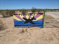
 view gallery view gallerySW26.4 km |  Feed the animals - Rooster Cogburn Ostrich Ranch-Picacho, AZ Feed the animals - Rooster Cogburn Ostrich Ranch-Picacho, AZ
in Feeding the Animals Feed different animals including Ostrich, Deer, Lorikeets and so many more! With the entrance fee you receive food for all the animal on the ranch..for $3 more you can get food to feed the stingrays.. posted by: grandmabetsy location: Arizona date approved: 03/07/2018 last visited: 02/14/2021 |
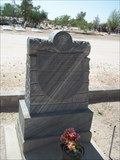
 view gallery view galleryNW26.4 km | U.S. General Land Office Survey Marker 1928 - Florence, AZ in U.S. Benchmarks This General Land Office survey marker is located just outside the city cemetery in Florence, Arizona. posted by: rjmcdonough1 location: Arizona date approved: 07/19/2017 last visited: never |
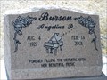 view gallery view galleryNW26.4 km |  Angelina P. Burson - Florence, Arizona Angelina P. Burson - Florence, Arizona
in Occupational/Hobby Grave Stones "Forever filling the heavens with her beautiful music." posted by: Tsegi Mike and Desert Viking location: Arizona date approved: 05/30/2011 last visited: 01/26/2012 |
 view gallery view galleryNW26.6 km |  Miguel R. Nunez - Florence, Arizona Miguel R. Nunez - Florence, Arizona
in Woodmen of the World Grave Markers/Monuments An unusual memorial in excellent condition. posted by: Tsegi Mike and Desert Viking location: Arizona date approved: 05/31/2011 last visited: 01/26/2012 |
|