 view gallery view gallery NW39.1 km NW39.1 km
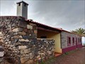
|   Centro de Receção Casa do Sardinha - Ponta de São Lourenço, Ilha da Madeira, Portugal Centro de Receção Casa do Sardinha - Ponta de São Lourenço, Ilha da Madeira, Portugal
in Ranger Stations Information centre and ranger station on the nature reserve peninsula of Ponta de São Lourenço. posted by:  Windschattenwanderer Windschattenwanderer location: Arquipélago da Madeira, Portugal date approved: 04/15/2022 last visited: never |
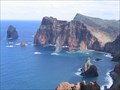
 view gallery view galleryNW39.1 km |  Ponta de São Lourenço - Caniçal, Madeira, Portugal Ponta de São Lourenço - Caniçal, Madeira, Portugal
in National Parks of the World Natural reserve in the northeast of Madeira Island. posted by: Windschattenwanderer location: Arquipélago da Madeira, Portugal date approved: 03/30/2019 last visited: 10/23/2022 |
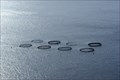 view gallery view galleryNW39.6 km |  Fish aquaculture - Caniçal, Madeira, Portugal Fish aquaculture - Caniçal, Madeira, Portugal
in Fish Hatcheries Fish aquaculture off the coast of the Ponta de São Lourenço on the Madeira archipelago posted by: Windschattenwanderer location: Arquipélago da Madeira, Portugal date approved: 08/06/2017 last visited: 10/23/2022 |
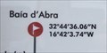 view gallery view galleryNW40.4 km |  N32° 44'36.06" W16° 42' 3.74" Baia d'Arbra - Madeira N32° 44'36.06" W16° 42' 3.74" Baia d'Arbra - Madeira
in Permanent Geographic Coordinates This information can be found on the PR8 information board at the start of the hike.
Esta informação pode ser encontrada no quadro informativo do PR8 no início da caminhada. posted by: franketmuriel location: Arquipélago da Madeira, Portugal date approved: 03/04/2020 last visited: never |
 view gallery view galleryNW40.4 km |  Ponto de São Lourenço, Madeira Ponto de São Lourenço, Madeira
in Scenic Hikes The trail out on the eastern tip of Madeira, Ponta de São Lourenço, is spectacular. This is saying a lot as there are many great hikes on this spectacular scenic island. Magnificent panoramas steep cliffs, jagged peaks, subtle details. All are here. posted by:  arby101ca arby101ca location: Arquipélago da Madeira, Portugal date approved: 12/16/2010 last visited: 10/23/2022 |
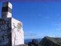 view gallery view galleryNW40.7 km |  Ponta do São Lourenço, Caniçal, Madeira Ponta do São Lourenço, Caniçal, Madeira
in Portugal Geodetic Points On the first peak of Ponta do São Lourenço, east of Caniçal is a Portuguese Geodetic marker. The 360 degree view from this point is wonderful. posted by: arby101ca location: Arquipélago da Madeira, Portugal date approved: 01/16/2011 last visited: 10/23/2022 |
 view gallery view galleryNW41.2 km |  Mirodouro, São Lourenço, Caniçal , Madeira Mirodouro, São Lourenço, Caniçal , Madeira
in Scenic Roadside Look-Outs There is an excellent scenic look-out giving views of the cliffs of Ponta do São Lourenço, the north east coast and the port of Caniçal. posted by: arby101ca location: Arquipélago da Madeira, Portugal date approved: 12/01/2010 last visited: 11/26/2019 |
 view gallery view galleryNW42.2 km |  SATA - SA de Transport Aérien - Flight 730 SATA - SA de Transport Aérien - Flight 730
in Plane Crash Sites The Sud Aviation SE-210 Caravelle 10R of SATA - SA de Transport Aérien - Flight 730, crashed in Madeira Airport killing 36 of the 57 people on board posted by: tmob location: Arquipélago da Madeira, Portugal date approved: 11/06/2011 last visited: 10/23/2022 |
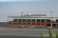 view gallery view galleryNW42.2 km |  Aeroporto da Madeira - Madeira, Portugal Aeroporto da Madeira - Madeira, Portugal
in Airports Madeira Airport (IATA: FNC, ICAO: LPMA), also known as Funchal Airport and Santa Catarina Airport, is an international airport located near Funchal, Madeira, Portugal. posted by: manchanegra location: Arquipélago da Madeira, Portugal date approved: 04/20/2009 last visited: 10/23/2022 |
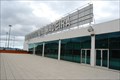
 view gallery view galleryNW42.2 km |  Aeroporto da Madeira - Madeira, Portugal Aeroporto da Madeira - Madeira, Portugal
in Wikipedia Entries Madeira Airport (IATA: FNC, ICAO: LPMA), also known as Funchal Airport and Santa Catarina Airport, is an international airport located near Funchal, Madeira, Portugal. posted by: manchanegra location: Arquipélago da Madeira, Portugal date approved: 07/15/2011 last visited: 10/23/2022 |
 view gallery view galleryNW42.2 km |  Madeira Airport Clock - Santa Cruz, Portugal Madeira Airport Clock - Santa Cruz, Portugal
in Town Clocks Clock mounted in the terrace of Madeira International Airport. posted by: manchanegra location: Arquipélago da Madeira, Portugal date approved: 11/02/2011 last visited: 10/23/2022 |
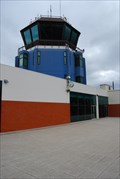
 view gallery view galleryNW42.2 km |  Aeroporto da Madeira - Madeira, Portugal Aeroporto da Madeira - Madeira, Portugal
in Inside Airports Madeira Airport (IATA: FNC, ICAO: LPMA), also known as Funchal Airport and Santa Catarina Airport, is an international airport located near Funchal, Madeira, Portugal. posted by: manchanegra location: Arquipélago da Madeira, Portugal date approved: 07/21/2011 last visited: 10/23/2022 |
 view gallery view galleryNW42.5 km |  Ancora - Caniçal, Madeira, Portugal Ancora - Caniçal, Madeira, Portugal
in Anchors Anchor located in a roundabout near Caniçal in Madeira. posted by: manchanegra location: Portugal date approved: 04/14/2009 last visited: 03/01/2013 |
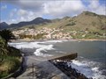 view gallery view galleryNW42.8 km |  Machico pier Machico pier
in Piers Machico´s Small Pier, there´s a larger one on the other end of the rocky beach. posted by: RuiJSDuarte location: Arquipélago da Madeira, Portugal date approved: 10/28/2011 last visited: 01/25/2023 |
 view gallery view galleryNW42.8 km | TP425 - Funchal Airport, Madeira, Portugal in Plane Crash Sites TAP Flight 425, tail number CS-TBR, was a Boeing 727 aircraft named Sacadura Cabral en route from Brussels, Belgium, to Madeira airport, Portugal. The plane crashed at the end of the runway on November 19, 1977. posted by: manchanegra location: Arquipélago da Madeira, Portugal date approved: 07/16/2011 last visited: 10/23/2022 |
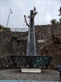 view gallery view galleryNW42.8 km |  Acidente de avião TAP 425 - Santa Cruz, Madeira, Portugal Acidente de avião TAP 425 - Santa Cruz, Madeira, Portugal
in Disaster Memorials Memorial do acidente aéreo de 19 de novembro de 1977. posted by: Windschattenwanderer location: Arquipélago da Madeira, Portugal date approved: 01/28/2024 last visited: never |
 view gallery view galleryNW43 km |  Pico do Facho - Machico, Madeira, Portugal Pico do Facho - Machico, Madeira, Portugal
in Cityscapes The best lookout point to see Machico. posted by: manchanegra location: Arquipélago da Madeira, Portugal date approved: 04/17/2009 last visited: 06/21/2015 |
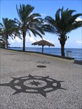 view gallery view galleryNW43.1 km |  Seaside Promenade Compass Roses, Santa Cruz, Madeira Seaside Promenade Compass Roses, Santa Cruz, Madeira
in Compass Roses In the paving stones of the seaside promenade in Santa Cruz , Madeira are a series of compass roses among other nautical motifs. posted by: arby101ca location: Arquipélago da Madeira, Portugal date approved: 11/07/2010 last visited: 01/23/2023 |
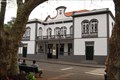 view gallery view galleryNW43.1 km |  Machico, Madeira, Portugal Machico, Madeira, Portugal
in City and Town Halls Machico City Hall posted by: manchanegra location: Arquipélago da Madeira, Portugal date approved: 04/21/2009 last visited: 01/25/2023 |
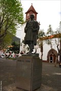 view gallery view galleryNW43.1 km |  Tristão Vaz Teixeira - Machico, Madeira, Portugal Tristão Vaz Teixeira - Machico, Madeira, Portugal
in Statues of Historic Figures Tristão Vaz Teixeira (c. 1395 – 1480) was a Portuguese navigator and explorer who, together with João Gonçalves Zarco and Bartolomeu Perestrelo, discovered the Madeira Islands posted by: manchanegra location: Arquipélago da Madeira, Portugal date approved: 04/17/2009 last visited: 01/25/2023 |
 view gallery view galleryNW43.1 km |  Igreja de Machico - Machico, Portugal Igreja de Machico - Machico, Portugal
in This Old Church This church was built after a XIV century chapel made by the will of Branca teixeira, daughter of the first Capitão Donatário of Machico. posted by: manchanegra location: Arquipélago da Madeira, Portugal date approved: 11/02/2011 last visited: 01/25/2023 |
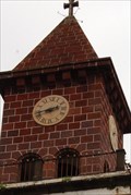 view gallery view galleryNW43.1 km | Relógio da Igreja de Machico - Machico, Portugal in Town Clocks Clock mounted in the Church of Machico in Madeira, Portugal. posted by: manchanegra location: Arquipélago da Madeira, Portugal date approved: 11/02/2011 last visited: 01/25/2023 |
 view gallery view gallery W45.7 km W45.7 km
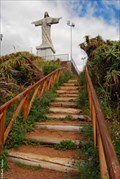
|  Cristo - Garajau, Madeira, Portugal Cristo - Garajau, Madeira, Portugal
in Statues of Religious Figures Christ Redeemer of Garajau posted by: manchanegra location: Arquipélago da Madeira, Portugal date approved: 04/19/2009 last visited: 02/09/2020 |
 view gallery view galleryW45.7 km | Ponta Garajau Geodetic Point in Portugal Geodetic Points At Ponta Garajau near the famous Cristo Rei statue is a standard Portuguese trig point. posted by: arby101ca location: Arquipélago da Madeira, Portugal date approved: 12/03/2016 last visited: 01/13/2020 |
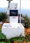
 view gallery view galleryNW48 km | Ponta do Espigão Amarelo, Porto da Cruz, Madeira in Portugal Geodetic Points At Ponta do Espigão Amarelo. (Yellow Point), half way along the sea cliff trail from Porto da Cruz to Boca do Risco is a stone block. This stone, painted black and white, is an obvious waymark, a Portuguese geodetic marker. posted by: arby101ca location: Arquipélago da Madeira, Portugal date approved: 12/03/2010 last visited: never |
|