 view gallery view gallery NE2.6 km NE2.6 km
|  ") Guadalupe Mountains National Park - Texas Guadalupe Mountains National Park - Texas
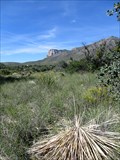
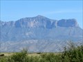
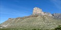
in National Parks (U.S.) The park is located in West Texas, reachable via US Hwy 62/180 (110mi E of El Paso, TX and 55mi SW of Carlsbad, NM). It includes Guadalupe Peak, the highest point in Texas, and El Capitan, long used as a landmark by early pioneers and stagecoaches. posted by:  Raven Raven location: Texas date approved: 11/05/2016 last visited: 10/16/2023 |
 view gallery view gallery S2.6 km S2.6 km
|  Summit Register -- Guadalupe Peak TX Summit Register -- Guadalupe Peak TX
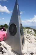
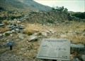
in Summit Registers The summit register of Guadalupe Peak, a standard US Government green cloth-bound logbook, is in an ammo can under the base of the summit monument. posted by: Benchmark Blasterz location: Texas date approved: 11/09/2012 last visited: 07/08/2022 |
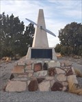
 view gallery view galleryS3.2 km |  Summit of Guadalupe Peak -- TX Summit of Guadalupe Peak -- TX
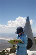
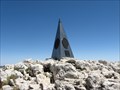
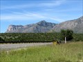
in Mountain Summits Guadalupe Peak is the highest point in Texas. Towering 8749 feet over Guadalupe Mountains National Park in Hidalgo Co. TX, you can see two countries (US & Mexico) and 3 states (US TX, US NM, and Chihuahua MX) from the top. posted by: Benchmark Blasterz location: Texas date approved: 09/16/2012 last visited: 09/07/2019 |
 view gallery view galleryS3.2 km |  Highest Point in Texas (Guadalupe Peak) Highest Point in Texas (Guadalupe Peak)
in Geographic High Points Guadalupe Peak is the highest point in Texas at 8749ft. It is located in Guadalupe Mountains National Park in west Texas, bordering New Mexico. The Guadalupes are one of the most extensive exposed fossil reef areas in the world. posted by: jackrock location: Texas date approved: 01/15/2010 last visited: 10/10/2004 |
 view gallery view galleryS3.2 km |  Guadalupe Peak (Texas) Guadalupe Peak (Texas)
in Wikipedia Entries Guadalupe Peak (also known as Signal Peak) is part of the Guadalupe Mountain range and -- at 8,749 feet -- the highest point in Texas. posted by: Raven location: Texas date approved: 11/08/2016 last visited: 09/07/2019 |
 view gallery view galleryS3.2 km |  Guadalupe Peak - Guadalupe Mountains, TX Guadalupe Peak - Guadalupe Mountains, TX
in Satellite Imagery Oddities Guadalupe Peak (also known as Signal Peak) is part of the Guadalupe Mountain range and -- at 8,749 feet -- the highest point in Texas. posted by: Raven location: Texas date approved: 11/14/2016 last visited: 04/06/2017 |
 view gallery view galleryS3.4 km | Guadalupe Mountains (Texas and New Mexico) in Wikipedia Entries The Guadalupe Mountains are a mountain range located in West Texas and SE New Mexico. The range includes the Texas' highest peak, parts of the largest exposed fossil reef in the world, and two US National Parks. posted by: Raven location: Texas date approved: 11/08/2016 last visited: 04/06/2017 |
 view gallery view gallery SE3.4 km SE3.4 km
| Guadalupe Mountains National Park (Texas) in Wikipedia Entries Guadalupe Mountains National Park in West Texas is a federally protected park in the USA. It contains portions the most extensive and significant Permian limestone fossil reef in the world. posted by: Raven location: Texas date approved: 11/09/2016 last visited: 10/16/2023 |
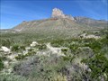
 view gallery view galleryS4.8 km | El Capitan (Texas) in Wikipedia Entries "El Capitan" is the southernmost promontory of the Guadalupe Mountain range in West Texas and Southeast New Mexico. It is a massive limestone formation long used as a landmark by early pioneers and stagecoaches. posted by: Raven location: Texas date approved: 11/08/2016 last visited: 07/28/2018 |
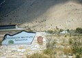
 view gallery view gallerySE5.3 km |  Guadalupe Mountains National Park Guadalupe Mountains National Park
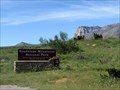
in NPS Passport Cancellation Stations The Guadalupe Mountains National Park is near the state border of Texas and New Mexico in the Chihauhuan desert of West Texas. The park contains the highest elevation in Texas and has El Capitan mountain that has been a landmark for travelers. posted by: WayBetterFinder location: Texas date approved: 09/03/2014 last visited: 02/16/2024 |
 view gallery view gallerySE5.3 km |  Ranger Station at Guadalupe Mountains National Park - Salt Flat TX Ranger Station at Guadalupe Mountains National Park - Salt Flat TX
in Ranger Stations The Ranger Station is inside the Guadalupe Mountains National Park Visitor Center located at 400 Pine Canyon Road, Salt Flat TX 79847. Here one may obtain a NPS Cancellation Stamp. posted by:  Don.Morfe Don.Morfe location: Texas date approved: 10/17/2023 last visited: 10/17/2023 |
 view gallery view gallerySE5.3 km |  Guadalupe Mountains National Park - Salt Flat TX Guadalupe Mountains National Park - Salt Flat TX
in National Parks of the World Guadalupe Mountains National Park Visitor Center is located at 400 Pine Canyon Road, Salt Flat TX 79847. posted by: Don.Morfe location: Texas date approved: 10/23/2023 last visited: 10/23/2023 |
 view gallery view gallerySE5.3 km |  Guadalupe Mountains National Park - Salt Flat TX Guadalupe Mountains National Park - Salt Flat TX
in Official Local Tourism Attractions The Guadalupe Mountains National Park Visitor Center is located at 400 Pine Canyon Road, Salt Flat TX 79847. posted by: Don.Morfe location: Texas date approved: 10/18/2023 last visited: 10/18/2023 |
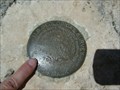 view gallery view gallery N5.8 km N5.8 km
|  R 1932 R 1932
in U.S. Benchmarks USGS bench mark stamped "R 1932" with the date of 1933 and elevation 7834 feet above sea level. posted by: jkselby location: Texas date approved: 10/17/2007 last visited: never |
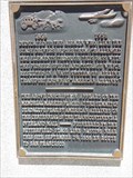
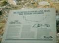 view gallery view gallerySE5.8 km |  Butterfield Overland Mail-The Pinery Station - Pine Springs TX Butterfield Overland Mail-The Pinery Station - Pine Springs TX
in Signs of History Marker is a short walk (220 feet) up a path from the parking lot along highway 62/180 near the entrance to Guadalupe Mountains National Park, Salt Flat TX 79847. posted by: Don.Morfe location: Texas date approved: 10/18/2023 last visited: 10/18/2023 |
 view gallery view gallerySE5.8 km |  Ruins of "The Pinery" or "Pine Spring" Stage Stand Ruins of "The Pinery" or "Pine Spring" Stage Stand
in Texas Historical Markers Ruins of a former Butterfield stage station dating back to 1859. posted by: rilekyle location: Texas date approved: 10/15/2006 last visited: 10/16/2023 |
 view gallery view gallerySE5.8 km |  American Airlines - 100 years - Guadalupe Mountains National Park, Salt Flat, TX USA American Airlines - 100 years - Guadalupe Mountains National Park, Salt Flat, TX USA
in Commercial Commemorations At this location near Hwy 62/180, close to the Visitors Center of the Guadalupe Mountains National Park, stands this commercial commemoration of the 100 years of mail service through the Guadalupe Pass. posted by: WayBetterFinder location: Texas date approved: 09/12/2014 last visited: 09/19/2016 |
 view gallery view gallerySE5.8 km |  Pinery Station - Pine Springs TX Pinery Station - Pine Springs TX
in U.S. National Register of Historic Places Pinery Station is located near Highway 62/180 at Pine Springs. Significant is the: Ruins of a stage station of the Butterfield Overland Mail used in 1858. posted by: Don.Morfe location: Texas date approved: 10/19/2023 last visited: 10/20/2023 |
 view gallery view gallerySE5.8 km | Pinery Station - Pine Springs TX in Wikipedia Entries Pinery Station is located near Highway 62/180 at Pine Springs. Significant is the: Ruins of a stage station of the Butterfield Overland Mail used in 1858. posted by: Don.Morfe location: Texas date approved: 10/16/2023 last visited: 10/16/2023 |
 view gallery view galleryS7.7 km |  El Capitan Look-Out - Guadalupe Mountains, TX El Capitan Look-Out - Guadalupe Mountains, TX
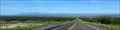
in Scenic Roadside Look-Outs This scenic lookout of El Capitan, the "signature peak" of West Texas, is located on US Hwy 62/180. It is 110mi East of El Paso, TX and 55mi Southwest of Carlsbad, NM. posted by: Raven location: Texas date approved: 11/08/2016 last visited: 07/28/2018 |
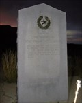
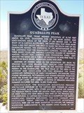 view gallery view galleryS7.7 km | Guadalupe Peak in Texas Historical Markers This Texas historical marker is within sight of the southern-most part of the very mountain range it discusses. posted by: WayBetterFinder location: Texas date approved: 09/07/2014 last visited: 03/13/2017 |
 view gallery view gallery SW21.7 km SW21.7 km
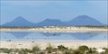
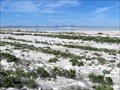
| Texas Salt Flats - Hudspeth County, TX in Satellite Imagery Oddities Located just west of the Guadalupe Mountains in the West Texas desert, the Texas Salt Flats are a remnant of an ancient, shallow lake that once occupied this area. The landscape is magical both "at street level" AND satellite view! posted by: Raven location: Texas date approved: 11/14/2016 last visited: 07/29/2018 |
 view gallery view gallerySW21.7 km |  Texas Salt Flats - Hudspeth County, TX, USA Texas Salt Flats - Hudspeth County, TX, USA
in Salt Pans and Mines The Texas salt flats were first cultivated by Native Americans, then by Spanish colonists, and ultimately by Texas Pioneers up until the early 20th century. posted by: Raven location: Texas date approved: 10/30/2016 last visited: 07/29/2018 |
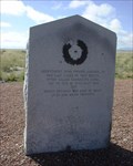 view gallery view gallerySW23.3 km | El Paso Salt War in Texas Historical Markers 1936 Centennial marker commemorating the 1877 El Paso Salt War near the site of the actual salt flats. posted by: rilekyle location: Texas date approved: 10/15/2006 last visited: 07/29/2018 |
 view gallery view galleryNE33.5 km |  The Flying Paperboy of the Guadalupes - Queen, NM The Flying Paperboy of the Guadalupes - Queen, NM
in Plane Crash Sites Frank A. Kendel, the "Flying Paperboy of the Guadalupes," was killed when his Piper Cub crashed near this spot in Queen, New Mexico. posted by: The Snowdog location: New Mexico date approved: 03/25/2021 last visited: 05/21/2023 |
|