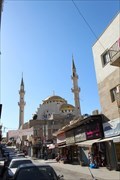
 view gallery view gallery NE16.7 km NE16.7 km
|   King Hussain Mosque, Madaba, Jordan King Hussain Mosque, Madaba, Jordan
in Mosques King Hussein Bin Talal Mosque, better known as the King Hussein Mosque, is the largest mosque in Jordan.[ posted by:  Beeklust Beeklust location: Jordan date approved: 06/10/2021 last visited: 01/12/2022 |
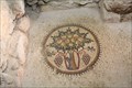 view gallery view galleryNE16.7 km |  Small tree laden with fruits Small tree laden with fruits
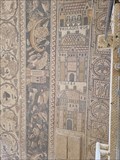
in Mosaics Ancient mosaic pavements in the Church of the profet Elias posted by: Beeklust location: Jordan date approved: 06/16/2021 last visited: 10/17/2017 |
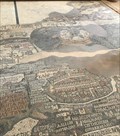 view gallery view galleryNE16.9 km |  King's Highway (Madaba) - Jordan King's Highway (Madaba) - Jordan
in 1000 Places to See Before You Die The Mosaic Map of Madaba from the second half of the 6th century. posted by: Walking Boots location: Jordan date approved: 07/26/2020 last visited: 10/05/2023 |
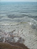
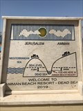 view gallery view gallery NW17.1 km NW17.1 km
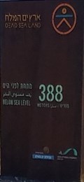
|  Dead Sea, Amman Beach Resort, Jordan, - 389 m Dead Sea, Amman Beach Resort, Jordan, - 389 m
in Elevation Signs Elevation sign at the Dead Sea posted by: Walking Boots location: Jordan date approved: 03/10/2020 last visited: 04/29/2022 |
 view gallery view galleryNW17.1 km |  Amman Beach Resort, Dead Sea, Jordan Amman Beach Resort, Dead Sea, Jordan
in 'You Are Here' Maps You are here sign at the Dead Sea posted by: Walking Boots location: Jordan date approved: 03/11/2020 last visited: 02/26/2023 |
 view gallery view galleryNW17.1 km |  Formación de evaporitas (Mar Muerto, Jordania) Formación de evaporitas (Mar Muerto, Jordania)
in Places of Geologic Significance La formación de rocas sedimentarias químicas en acción en "Amman Tourist Beach". The deposit of sedimentary rock chemical in action in "Amman Tourist Beach". posted by:  monticola monticola location: Jordan date approved: 07/28/2009 last visited: 03/21/2023 |
 view gallery view galleryNW18 km |  LOWEST - Geocache on Earth LOWEST - Geocache on Earth
in Superlatives Near the shore of the Dead Sea in Jordan posted by: g300td location: Jordan date approved: 11/15/2014 last visited: 11/19/2023 |
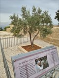 view gallery view gallery N20.3 km N20.3 km
|  Olivam Hanc - Mount Nebo - Jordan Olivam Hanc - Mount Nebo - Jordan
in Historic Trees Olive tree planted during the pilgrimage of the pope to the Holy Land. posted by: PaulLassiter location: Jordan date approved: 11/15/2023 last visited: never |
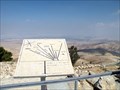 view gallery view galleryN20.3 km |  Mount Nebo Orientation Panel (Jordan) Mount Nebo Orientation Panel (Jordan)
in Orientation Tables El panel señala hacia diversas ciudades desde el punto en que, según la Biblia, Moisés comtempló el valle del río Jordán. The panel shows the direction to various cities from the point where, according to the Bible, Moses saw the Jordan River Valley. posted by: monticola location: Jordan date approved: 09/09/2009 last visited: 10/01/2023 |
 view gallery view galleryN20.3 km |  Mount Nebo Mount Nebo
in Names From the Bible Mount Nebo posted by: Beeklust location: Jordan date approved: 06/09/2021 last visited: 10/05/2023 |
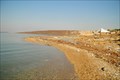 view gallery view galleryNW20.9 km |  Dead Sea Public Beach, Madaba, Jordan Dead Sea Public Beach, Madaba, Jordan
in Beaches One of a few available public beaches in the Jordanian side of the Dead Sea posted by: Torgut location: Jordan date approved: 12/14/2011 last visited: 10/01/2023 |
 view gallery view gallery SE22.7 km SE22.7 km
| Mephaat - Jordan in Names From the Bible In the Bible's book of Jeremiah, Mephaat was condemned to destruction. posted by: PaulLassiter location: Jordan date approved: 01/21/2024 last visited: never |
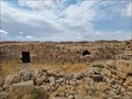
 view gallery view gallerySE22.7 km |  Umm ar-Rasas - Amman Governorate, Jordan Umm ar-Rasas - Amman Governorate, Jordan
in Wikipedia Entries UNESCO World Heritage Site related to the ruins of the Roman, Byzantine, and early Muslim civilizations posted by: PaulLassiter location: Jordan date approved: 11/22/2023 last visited: never |
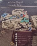 view gallery view gallerySE22.7 km | You are here, in the ruins of Umm ar-Rasas - Jordan in 'You Are Here' Maps Description of different places in the ruins of ancient city Umm ar-Rasas. posted by: PaulLassiter location: Jordan date approved: 11/21/2023 last visited: never |
 view gallery view gallerySE22.7 km |  Um er-Rasas (Kastrom Mefa'a) - Amman Governorate, Jordan Um er-Rasas (Kastrom Mefa'a) - Amman Governorate, Jordan
in World Heritage Sites Archaeological site containing remains from the Roman, Byzantine and Early Muslim periods and a fortified Roman military camp. posted by: PaulLassiter location: Jordan date approved: 11/22/2023 last visited: never |
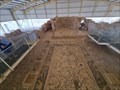
 view gallery view gallerySE22.7 km | St. Stephen: Mosaics of cities, Umm ar-Rasas - Amman Governorate, Jordan in Mosaics A perfectly preserved remarkable and the largest mosaic floor in Jordan with a series of panels illustrating the most important cities of the region. posted by: PaulLassiter location: Jordan date approved: 11/25/2023 last visited: never |
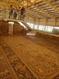 view gallery view gallerySE22.7 km | Umm ar-Rasas mosaics - Amman Governorate, Jordan in Wikipedia Entries A perfectly preserved remarkable mosaic floor, the largest one in Jordan. posted by: PaulLassiter location: Jordan date approved: 11/22/2023 last visited: never |
 view gallery view galleryNW28 km | Dead Sea Elevation Mark - Megilot Dead Sea Regional Council, Israel - -388m in Elevation Signs Elevation sign at the Dead Sea - lowest land elevation on Earth posted by: ambegador location: Israel date approved: 01/03/2020 last visited: 05/12/2019 |
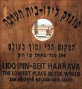 view gallery view galleryNW28 km | Lido Inn-Beit Haarava, Israel. - 394 m in Elevation Signs Elevation sign on the way to the Dead Sea posted by: Walking Boots location: Israel date approved: 03/12/2020 last visited: never |
 view gallery view gallery SW32.5 km SW32.5 km
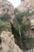
|  David Falls - En Gedi - Israel David Falls - En Gedi - Israel
in Waterfalls Ein Gedi (Hebrew: ???? ????????, Arabic: ??? ????, romanized: 'Ain Jidy), also spelt En Gedi, meaning "spring of the kid" posted by: Beeklust location: Israel date approved: 06/23/2021 last visited: 06/25/2021 |
 view gallery view galleryNW37.3 km | Sea Level - Route 1, Mitspe Yeriho, Israel - 0m in Elevation Signs Sea Level Marker in mountains of Israel posted by: ambegador location: Israel date approved: 01/03/2020 last visited: 02/04/2020 |
 view gallery view gallerySW44.6 km |  Masada, Ancient fortress - Masada, Israel Masada, Ancient fortress - Masada, Israel
in 3D Map Models of Our World and Beyond A 3D model of a rock cliff with the ancient fortress of Masada, southern Israel, located at the lower station of the cable car posted by: ashberry location: Israel date approved: 09/23/2021 last visited: never |
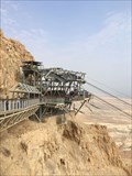 view gallery view gallerySW44.6 km |  Masada Cable Car - Masada, Israel Masada Cable Car - Masada, Israel
in Aerial Lifts The Masada Cable Car is an aerial lift at the ancient fortress of Masada, Israel. posted by: ashberry location: Israel date approved: 06/19/2021 last visited: never |
 view gallery view gallerySW44.6 km | Masada cableway - Masada, Israel in Wikipedia Entries The Masada Cable Car is an aerial lift at the ancient fortress of Masada, Israel. posted by: ashberry location: Israel date approved: 06/24/2021 last visited: never |
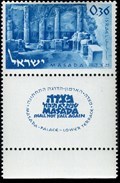 view gallery view gallerySW44.6 km |  Masada - Israel Masada - Israel
in Philatelic Photographs This is Masada, an ancient fortress on the Dead Sea. The stamp from 1965 represents the lowest part of Herod's palace, the so-called Lower Terrace. posted by: ashberry location: Israel date approved: 06/21/2021 last visited: never |
|