 view gallery view gallery N1.4 km N1.4 km
|   Canyon Lake (Texas) Canyon Lake (Texas)
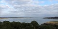
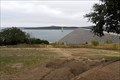
in Wikipedia Entries Canyon Lake is a man-made reservoir on the Guadalupe River, 15 miles northwest of New Braunfels, Texas. posted by:  Raven Raven location: Texas date approved: 05/04/2015 last visited: 08/20/2021 |
 view gallery view gallery S4.2 km S4.2 km
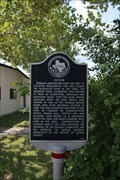
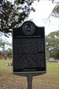
|  Startzville Community Startzville Community
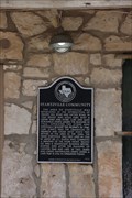
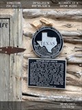
in Texas Historical Markers Texas State historical marker for Startzville Community in Canyon Lake Texas posted by: Benchmark Blasterz location: Texas date approved: 04/13/2023 last visited: 04/13/2023 |
 view gallery view galleryN6.4 km |  Labyrinth at North Shore UMC, Canyon Lake, Texas USA Labyrinth at North Shore UMC, Canyon Lake, Texas USA
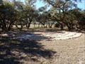
in Labyrinths A 6-circuit labyrinth at the North Shore United Methodist Church at 23880 North Cranes Mill Road, Canyon Lake, TX 78133. Enter the parking lot, then go left to the columbarium. Take the steps up to the hilltop and you will be at the labyrinth. posted by: WayBetterFinder location: Texas date approved: 12/16/2022 last visited: 12/17/2022 |
 view gallery view gallery E7.2 km E7.2 km
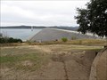
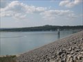
| Canyon Dam (Texas) in Wikipedia Entries Canyon Dam is a rolled-earth dam on the Guadalupe River in Texas, USA. It was completed in 1964 and its impounded water forms Canyon Lake, a popular recreational spot in Central Texas. posted by: Raven location: Texas date approved: 12/24/2014 last visited: 08/20/2021 |
 view gallery view galleryE7.2 km |  HIGHEST -- Earthen Dam in Texas - Canyon Lake, TX HIGHEST -- Earthen Dam in Texas - Canyon Lake, TX
in Superlatives Canyon Dam is a rolled-earth dam on the Guadalupe River in Texas, USA. Completed in 1964 by the U.S. Corps of Engineers and rising 224 feet above the streambed, it is the highest earthen dam in Texas. posted by: Raven location: Texas date approved: 12/25/2014 last visited: 08/20/2021 |
 view gallery view galleryE7.2 km |  Canyon Lake Dam- Texas Canyon Lake Dam- Texas
in Water Dams Canyon Lake Dam is on the Guadalupe river and helped form Canyon Lake. posted by:  CEEC CEEC location: Texas date approved: 05/01/2009 last visited: 08/20/2021 |
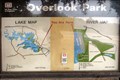 view gallery view galleryE7.2 km |  Overlook Park Map - Canyon Lake, TX Overlook Park Map - Canyon Lake, TX
in 'You Are Here' Maps Overlook Park offers a scenic view of both Canyon Dam and Canyon Lake, located in the Texas Hill Country. posted by: Raven location: Texas date approved: 12/23/2014 last visited: 12/06/2014 |
 view gallery view gallery SE9.7 km SE9.7 km
| Sattler in Texas Historical Markers The state historical marker for the Comal County community of Sattler. posted by: Benchmark Blasterz location: Texas date approved: 04/14/2023 last visited: 04/20/2023 |
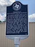 view gallery view galleryE10 km | Original Site of Mountain Valley School in Texas Historical Markers The state historical marker at the Comal County community of Sattler preserves the memory of the original site of the Mountain Valley School posted by: Benchmark Blasterz location: Texas date approved: 04/16/2023 last visited: 04/20/2023 |
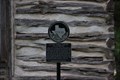
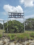 view gallery view galleryN10.5 km |  Fischer Cemetery - Fischer, TX Fischer Cemetery - Fischer, TX
in Worldwide Cemeteries Listed on the National Register of Historic Places. One non-historic chain-link fence wraps around the property boundaries and another wraps around the area of the cemetery containing the burials. posted by: WalksfarTX location: Texas date approved: 07/21/2020 last visited: never |
 view gallery view galleryN10.5 km |  Fischer Cemetery - Fischer Historic District - Fischer, TX Fischer Cemetery - Fischer Historic District - Fischer, TX
in NRHP Historic Districts - Contributing Buildings Historical Marker in front on a large boulder. posted by: WalksfarTX location: Texas date approved: 07/22/2020 last visited: never |
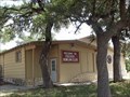
 view gallery view galleryE10.5 km | Sattler Post Office in Texas Historical Markers The fachework log cabin that served as an early US Post Office serving the Comal County community of Sattler posted by: Benchmark Blasterz location: Texas date approved: 04/14/2023 last visited: 04/20/2023 |
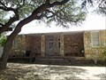
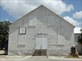
 view gallery view galleryN10.6 km |  Fischer School - Fischer, TX Fischer School - Fischer, TX
in Former Schools The school functioned as such until 1957, and it now serves as the Fischer Store School Community Center. posted by: WalksfarTX location: Texas date approved: 07/21/2020 last visited: never |
 view gallery view galleryN10.6 km | Fischer School - Fischer Historic District - Fischer, TX in NRHP Historic Districts - Contributing Buildings Built sometime in 1940, Fischer School replaced the community’s first school that burned down in January of that year. The one-story, two-room school was built in part using National Youth Administration labor and government aid. posted by: WalksfarTX location: Texas date approved: 07/22/2020 last visited: never |
 view gallery view galleryN10.6 km |  Fischer School - Fischer, TX Fischer School - Fischer, TX
in WPA Projects The school functioned as such until 1957, and it now serves as the Fischer Store School Community Center. posted by: WalksfarTX location: Texas date approved: 07/21/2020 last visited: never |
 view gallery view galleryN10.6 km |  Fischer Historic District - Fischer, TX Fischer Historic District - Fischer, TX
in U.S. National Register of Historic Places Coordinates given are for the Fischer Store, which is at the south end of the district. posted by: WalksfarTX location: Texas date approved: 07/23/2020 last visited: never |
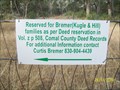
 view gallery view galleryN10.6 km | Fischer Store Property - Fischer Historic District - Fischer, TX in NRHP Historic Districts - Contributing Buildings The building features Juniper piers, Long Leaf Pine beams, tin siding and six-over-six double-hung Cypress frame windows with wavy glass panes. The interior walls are lined with custom shelving. posted by: WalksfarTX location: Texas date approved: 07/22/2020 last visited: never |
 view gallery view gallery SW10.6 km SW10.6 km
| No Name Cemetery, Hwy 311, Comal County, Texas in Worldwide Cemeteries This is a quiet cemetery off Hwy 311 between New Braunfels and Blanco. posted by: mom2kutternkaden location: Texas date approved: 12/01/2010 last visited: never |
 view gallery view gallerySW10.6 km | Smithson Valley Cemetery in Texas Historical Markers The historic Texas Cemetery historical marker for the Smithson Valley Cemetery and rapidly urbanizing Comal County posted by: Benchmark Blasterz location: Texas date approved: 04/16/2023 last visited: 04/20/2023 |
 view gallery view galleryN10.8 km | Agricultural Society of Fischer in Texas Historical Markers The Agricultural Society of Fischer historical marker in the small Blanco County town of Fischer posted by: Benchmark Blasterz location: Texas date approved: 04/21/2023 last visited: 04/22/2023 |
 view gallery view galleryN11.1 km | Fischer Bowling Alley - Fischer Historic District - Fischer, TX in NRHP Historic Districts - Contributing Buildings Despite its many additions and alterations, the building’s integrity of setting, location, association, and feeling allow it to convey its significance and its role in Fischer’s history, and therefore is
contributing. posted by: WalksfarTX location: Texas date approved: 07/21/2020 last visited: never |
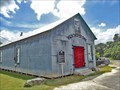
 view gallery view galleryN11.1 km | Fischer Hall - Fischer Historic District - Fischer, TX in NRHP Historic Districts - Contributing Buildings The hall, with laminated pine arches to vault the ceiling, was designed by a man named Kloepper from New Braunfels. posted by: WalksfarTX location: Texas date approved: 07/22/2020 last visited: never |
 view gallery view gallerySE11.4 km | Jacob's Creek School Teacherage in Texas Historical Markers The official state historical marker at the location of the Jacob's Creek School Teacherage posted by: Benchmark Blasterz location: Texas date approved: 04/21/2023 last visited: 04/22/2023 |
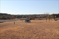 view gallery view gallerySW12.1 km | Hill Country Memorial Gardens, Blanco County, Texas, USA in Worldwide Cemeteries A perpetual care cemetery in the Texas Hill Country. There are about 130 graves here. You will find a wooden cross near the front, God's Little Garden - a resting place for babies under 1 year, and lots of trees. posted by: mom2kutternkaden location: Texas date approved: 12/23/2010 last visited: never |
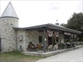 view gallery view galleryS12.4 km |  Dry Comal Creek VIneyards and Winery- New Braunfels, Texas Dry Comal Creek VIneyards and Winery- New Braunfels, Texas
in Wineries Dry Comal Creek Vineyards and Winery is located off Hwy 46 (north )on Herbelin Road about 8 miles outside of New Braunfels, Texas. The vineyards first produced grapes in 1995 and the first wine in 1998. posted by: CEEC location: Texas date approved: 07/25/2008 last visited: 07/16/2008 |
|