 view gallery view gallery SE0 km SE0 km
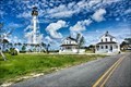
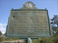
|   Cape San Blas Lighthouse - Port St Joe, FL Cape San Blas Lighthouse - Port St Joe, FL
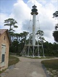
in Coastal Lighthouses The Cape San Blas Light is a lighthouse in the state of Florida in the United States. There were four built between 1849 and 1885. posted by:  nomadwillie nomadwillie location: Florida date approved: 11/25/2019 last visited: 06/08/2020 |
 view gallery view gallery E0.3 km E0.3 km
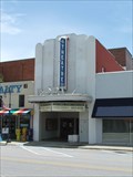
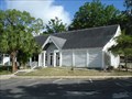
|  Port Theatre, Port St. Joe, Florida Port Theatre, Port St. Joe, Florida
in Vintage Movie Theaters The Port was built in 1938 in the art-deco style. posted by:  Wallyum Wallyum location: Florida date approved: 08/17/2009 last visited: 03/06/2018 |
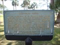 view gallery view gallerySE0.3 km |  Shipyard Cove Shipyard Cove
in Florida Historical Markers The smallest (in size) Florida Historical Marker. The only one like it in the state. posted by: Markerman62 location: Florida date approved: 01/03/2012 last visited: 03/06/2018 |
 view gallery view gallery S2.4 km S2.4 km
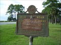
|  U.S. 98, Port St. Joe, FL U.S. 98, Port St. Joe, FL
in Blue Star Memorial Highway Markers Blue Star Memorial Highway, Port St. Joe. posted by: garmin_geek location: Florida date approved: 08/27/2013 last visited: 04/26/2018 |
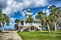
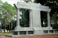 view gallery view galleryS2.4 km |  Florida Constitution Convention Monument Florida Constitution Convention Monument
in Community Commemoration This monument which was erected in 1923 sits within a beautiful 12 acre state park and is dedicated to the founding of the State of Florida and its first constitutional convention (1838). posted by: geojedi33 location: Florida date approved: 03/21/2011 last visited: 03/08/2018 |
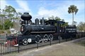 view gallery view gallerySE2.4 km |  St. Joe Lumber & Export #11 - Port St. Joe, FL St. Joe Lumber & Export #11 - Port St. Joe, FL
in Locomotives This 1917 2-6-2 “Prairie” spent about 40 years hauling lumber and other wood products for various mills in Florida and Georgia. posted by: hykesj location: Florida date approved: 01/29/2023 last visited: never |
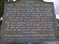 view gallery view gallerySE2.9 km | Old St. Joseph Cemetery in Florida Historical Markers Old City Cemetery posted by: Coinseekers location: Florida date approved: 07/12/2009 last visited: 07/08/2018 |
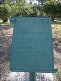 view gallery view gallerySE2.9 km | St. Joseph Cemetery Burial List (Untitled) in Florida Historical Markers Another unusual marker in Port St Joe. posted by: Markerman62 location: Florida date approved: 01/09/2012 last visited: 04/10/2018 |
 view gallery view gallerySE2.9 km | Saint Joseph Cemetery in Florida Historical Markers Just outside of Port St Joe. posted by: Markerman62 location: Florida date approved: 01/09/2012 last visited: 04/10/2018 |
 view gallery view galleryS7.2 km | St. Joseph Point Lighthouse - Port St Joe, FL in Coastal Lighthouses The St. Joseph Point Light was a lighthouse on the mainland north of present-day Port St. Joe, Florida, across the entrance to St. Joseph Bay from St. Joseph Point. posted by: nomadwillie location: Florida date approved: 11/25/2019 last visited: never |
 view gallery view gallery SW10.9 km SW10.9 km
|  St Joseph's Penninsula State Park St Joseph's Penninsula State Park
in Campgrounds The campsites at St Joseph's Penninsula St Park provide the perfect seaside getaway. posted by: ElectricBird location: Florida date approved: 02/26/2006 last visited: 03/06/2018 |
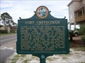 view gallery view gallery NW11.6 km NW11.6 km
| Fort Crevecoeur/Fort Crevecoeur Abandoned in Florida Historical Markers Along US 98 west of Port St Joe. posted by: Markerman62 location: Florida date approved: 01/09/2012 last visited: 04/19/2018 |
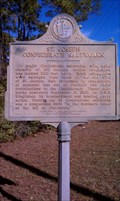 view gallery view galleryS14.6 km | St. Joseph Confederate Saltworks in Florida Historical Markers One of many salt works in this part of the coast attacked by the Federals during the Civil War posted by: Data Wrangler location: Florida date approved: 02/04/2012 last visited: 03/06/2018 |
 view gallery view galleryS16.6 km | Lighthouse Cape San Blas, FL in Coastal Lighthouses Looks a little rusty. posted by: BackPak location: Florida date approved: 08/09/2006 last visited: 06/08/2020 |
 view gallery view gallery NE29.3 km NE29.3 km
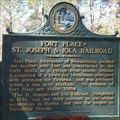
| Fort Place-St. Joseph & Iola railroad in Florida Historical Markers Former Fort Place, now known as Wewahitchka. posted by: Living Energy location: Florida date approved: 02/16/2011 last visited: 02/09/2017 |
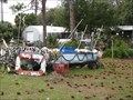
 view gallery view galleryE30.4 km |  Boat One, Apalachicola FL Boat One, Apalachicola FL
in Landlocked Boats One of 2 Land Locked Boats in this yard. posted by: Queens Blessing location: Florida date approved: 01/18/2009 last visited: 04/05/2018 |
 view gallery view galleryE30.4 km | Boat Two, Apalachicola FL in Landlocked Boats There are 2 Land Locked Boats in this yard. posted by: Queens Blessing location: Florida date approved: 01/18/2009 last visited: 04/05/2018 |
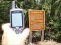
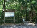 view gallery view galleryE31.4 km |  ANERR Estuarine Walk Trailhead - Apalachicola, FL ANERR Estuarine Walk Trailhead - Apalachicola, FL
in Hiking and walking trailheads This trailhead for the Estuarine Walk is located across from the nature center in the Apalachicola National Estuarine Research Reserve in Apalachicola, Florida, USA. posted by: Marine Biologist location: Florida date approved: 02/28/2010 last visited: 04/09/2018 |
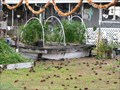
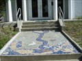 view gallery view galleryE31.4 km |  ANERR Nature Center Mosaic - Apalachicola, FL ANERR Nature Center Mosaic - Apalachicola, FL
in Mosaics A beautiful mosaic leads the way to the entrance to the Apalachicola National Estuarine Research Reserve Nature Center in city of Apalachicola in Franklin County, Florida, USA. posted by: Marine Biologist location: Florida date approved: 02/28/2010 last visited: 04/09/2018 |
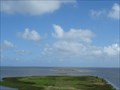 view gallery view galleryE31.4 km |  Central Gulf Coast Plain Biosphere - Apalachicola, Florida, USA Central Gulf Coast Plain Biosphere - Apalachicola, Florida, USA
in UNESCO Geoparks and Biosphere Reserves The Central Gulf Coast Plain Biosphere Reserve is located in northwest Florida, USA. It comprises Apalachicola Bay, including the Apalachicola National Estuarine Research Reserve. The visitor center is located in Apalachicola, Florida. posted by: Marine Biologist location: Florida date approved: 07/22/2015 last visited: 04/09/2018 |
 view gallery view galleryE31.4 km |  ANERR Nature Center - Apalachicola, FL ANERR Nature Center - Apalachicola, FL
in Nature Centers The Apalachicola National Estuarine Research Reserve Nature Center in city of Apalachicola in Franklin County, Florida, USA. posted by: Marine Biologist location: Florida date approved: 02/28/2010 last visited: 04/09/2018 |
 view gallery view galleryE31.4 km |  Apalachicola National Estuarine Research Reserve Apalachicola National Estuarine Research Reserve
in Wikipedia Entries The Apalachicola National Estuarine Research Reserve is located in Franklin, Gulf, and Liberty Counties in the panhandle of Florida. posted by: Marine Biologist location: Florida date approved: 03/01/2010 last visited: 04/09/2018 |
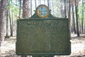 view gallery view galleryNE31.7 km | Milly Francis in Florida Historical Markers Located off Hwy 65 on FR-129 in the Apalachicola National Forest in Franklin County, Fla. posted by: Coinseekers location: Florida date approved: 04/08/2010 last visited: 12/10/2012 |
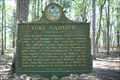 view gallery view galleryNE31.7 km | Fort Gadsden in Florida Historical Markers Located off Hwy 65 on FR-129 in Apalachicola National Forest in Franklin County, Fla. posted by: Coinseekers location: Florida date approved: 04/06/2010 last visited: 12/10/2012 |
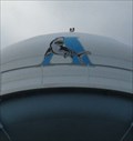 view gallery view galleryE31.9 km |  Shark on Water Tower - Apalachicola, FL Shark on Water Tower - Apalachicola, FL
in Water Towers There is a very nice shark symbol on the water tower in Apalachicola near the Veterans Park and Orman House State Park. posted by: Queens Blessing location: Florida date approved: 01/16/2009 last visited: 04/09/2018 |
|