 view gallery view gallery NW3.5 km NW3.5 km
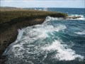
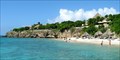
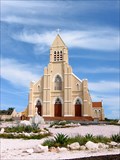
|   Shete Boka National Park - Curacao Shete Boka National Park - Curacao
in National Parks of the World Shete Boka National Park is located on the rugged Northern coast of the island of Curacao. Its main attractions are huge wind-borne waves thundering onto a rocky shoreline and a natural wildlife preserve for sea turtles coming to lay their eggs. posted by:  Raven Raven location: Curaçao date approved: 03/17/2013 last visited: 03/13/2015 |
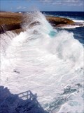 view gallery view galleryNW3.7 km |  Boka Tabla - Curacao Boka Tabla - Curacao
in Wavy Places Boka Tabla one of 7 tiny inlets all located within Curacao's small Shete Boka National Park located on the island's rugged North coast. Its main attraction are huge waves thundering onto the rocky shore and into an underground cavern. posted by: Raven location: Curaçao date approved: 03/16/2013 last visited: 03/13/2015 |
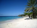
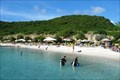
 view gallery view gallery W5.8 km W5.8 km
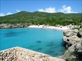
|  Playa Kenepa Grandi - Curacao Playa Kenepa Grandi - Curacao
in Beaches Playa Kenepa Grandi (or "Grote Knip" in Dutch) is a beach located at the northwestern tip of the island of Curacao. It is a very picturesque spot and often featured on tourism brochures. posted by: Raven location: Curaçao date approved: 03/10/2013 last visited: 01/20/1994 |
 view gallery view galleryW5.8 km |  Playa Kenepa Grandi - Curacao Playa Kenepa Grandi - Curacao
in Philatelic Photographs Playa Kenepa Grandi (or "Grote Knip" in Dutch) is a beach located at the northwestern tip of the island of Curacao. It is a very picturesque spot and often featured on tourism brochures. posted by: Raven location: Curaçao date approved: 02/11/2019 last visited: 01/20/1994 |
 view gallery view galleryW5.8 km |  Grote Knip (Curacao) Grote Knip (Curacao)
in Wikipedia Entries Grote Knip (Papiamentu: "Playa Kenepa Grandi" or "Playa Kenepa Abou") is a beach located at the northwestern tip of the island of Curacao. It is a very picturesque spot and often featured on tourism brochures. posted by: Raven location: Curaçao date approved: 03/10/2013 last visited: 04/19/2017 |
 view gallery view galleryNW7.4 km | Playa Kalki - Curacao in Beaches Playa Kalki (also referred to as "Alice In Wonderland" by scuba divers) is a tiny beach located at the northwestern tip of the island of Curacao. posted by: Raven location: Curaçao date approved: 03/10/2013 last visited: 03/13/2015 |
 view gallery view galleryNW7.4 km | Playa Kalki (Curacao) in Wikipedia Entries Playa Kalki (also referred to as "Alice In Wonderland" by scuba divers) is a tiny beach located at the northwestern tip of the island of Curacao. posted by: Raven location: Curaçao date approved: 03/10/2013 last visited: 03/13/2015 |
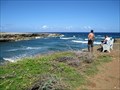 view gallery view gallery SE9 km SE9 km
| Boka Ascencion - Curacao in Wavy Places Boka Ascencion is an inlet on the rugged Northern coast of the island of Curacao that gets battered by Northeast Trade Winds year-round. It is a sanctuary for several sea turtle species that come and lay their eggs on a tiny beach nearby. posted by: Raven location: Curaçao date approved: 03/17/2013 last visited: 12/16/2019 |
 view gallery view gallery S12.6 km S12.6 km
| Cas Abao Beach - Curacao in Beaches Cas Abao is a beach and luxury residential neighborhood located at the western end of the island of Curacao. posted by: Raven location: Curaçao date approved: 03/10/2013 last visited: 11/21/2017 |
 view gallery view galleryS13.5 km | Playa Porto Marie (Curacao) in Wikipedia Entries Playa Porto Marie is a sandy bay and scuba diving mecca located at the western end of the island of Curacao. Although situated on a private Plantation estate, the beach itself is accessible to the public year-round. posted by: Raven location: Curaçao date approved: 03/10/2013 last visited: 11/21/2017 |
 view gallery view galleryS13.5 km | Playa Porto Mari - Curacao in Beaches Playa Porto Mari is a sandy bay and scuba diving mecca located at the western end of the island of Curacao. Although situated on a private Plantation estate, the beach itself is accessible to the public year-round. posted by: Raven location: Curaçao date approved: 03/10/2013 last visited: 11/21/2017 |
 view gallery view galleryS14.3 km | Sint Willibrordus (Curacao) in Wikipedia Entries Sint Willibrordus is a small town located in the western half of the island of Curacao, about 25 km West of the capital Willemstad. posted by: Raven location: Curaçao date approved: 03/17/2013 last visited: 11/21/2017 |
 view gallery view gallerySE22.5 km | Kokomo Beach - Curacao in Beaches Kokomo Beach is a recently revamped free-access (no entrance fee) beach located just 10km West of downtown Willemstad, the capital of Curacao. posted by: Raven location: Curaçao date approved: 03/10/2013 last visited: 11/05/2014 |
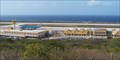
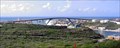
 view gallery view gallerySE23.2 km |  Hato International Airport - Curacao Hato International Airport - Curacao
in Airports Hato International Airport (also known as Curacao International Airport) is the one and only commercial airport on the island of Curacao, located to the North of the capital Willemstad. posted by: Raven location: Curaçao date approved: 03/15/2013 last visited: 04/12/2017 |
 view gallery view gallerySE23.2 km |  Hato International Airport - Curacao Hato International Airport - Curacao
in Satellite Imagery Oddities Hato International Airport (also known as Curacao International Airport) is the one and only commercial airport on the island of Curacao, located to the North of the capital Willemstad. posted by: Raven location: Curaçao date approved: 02/10/2019 last visited: 02/15/2019 |
 view gallery view gallerySE23.2 km | Hato International Airport (Curacao) in Wikipedia Entries Hato International Airport (also known as Curacao International Airport) is the one and only commercial airport on the island of Curacao, located to the North of the capital Willemstad. posted by: Raven location: Curaçao date approved: 03/10/2013 last visited: 04/12/2017 |
 view gallery view gallerySE23.2 km |  Hato International Airport - Curacao Hato International Airport - Curacao
in Inside Airports Hato International Airport (also known as Curacao International Airport) is the one and only airport on the island of Curacao: it offers all amenities one would usually expect from a gateway into an international tourist destination. posted by: Raven location: Curaçao date approved: 03/09/2013 last visited: 04/12/2017 |
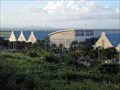
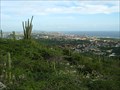 view gallery view gallerySE28.8 km |  Seru Pretu ("Antenna Farm") Overlook - Curacao Seru Pretu ("Antenna Farm") Overlook - Curacao
in Scenic Overlooks A 180° view of Willemstad, the capital of Curacao, as seen from the "Antenna Farm", a spot at the top of Seru Pretu (about 105m / 345' elevation). posted by: Raven location: Curaçao date approved: 03/27/2014 last visited: 11/21/2017 |
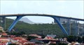
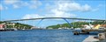
 view gallery view gallerySE31.2 km |  HIGHEST -- Bridge in the Caribbean - Willemstad, Curacao HIGHEST -- Bridge in the Caribbean - Willemstad, Curacao
in Superlatives The Queen Juliana bridge is a four-lane road arch bridge crossing the St. Anna Bay in Willemstad, the capital of Curacao. Reaching a height of 56.4 m (185 ft) above the waterline at its apex, it is the highest bridge in the entire Caribbean. posted by: Raven location: Curaçao date approved: 03/19/2013 last visited: 12/11/2018 |
 view gallery view gallerySE31.4 km | Queen Juliana Bridge - Willemstad, Curaçao in Satellite Imagery Oddities The Queen Juliana Bridge (Koningin Julianabrug) is a four lane road bridge across St. Anna Bay in Willemstad, the capital of Caribbean island country Curaçao. posted by:  denben denben location: Curaçao date approved: 01/02/2019 last visited: 03/14/2017 |
 view gallery view gallerySE31.4 km |  Queen Juliana Bridge - Willemstad, Curacao Queen Juliana Bridge - Willemstad, Curacao
in People-Named Places The Queen Juliana bridge is a four-lane road arch bridge crossing the St. Anna Bay in Willemstad, the capital of Curacao. It was named after a former monarch of the royal Dutch family. posted by: Raven location: Curaçao date approved: 02/11/2019 last visited: 03/14/2017 |
 view gallery view gallerySE31.4 km |  Queen Juliana Bridge - Willemstad, Curacao Queen Juliana Bridge - Willemstad, Curacao
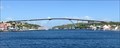
in Arch Bridges The Queen Juliana bridge is a four-lane road arch bridge crossing the St. Anna Bay in Willemstad, the capital of Curacao. Reaching a height of 56.4 m (185 ft) above the waterline at its apex, it is the highest bridge in the entire Caribbean. posted by: Raven location: Curaçao date approved: 03/21/2013 last visited: 12/11/2018 |
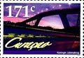 view gallery view gallerySE31.4 km | Queen Juliana Bridge - Willemstad, Curacao in Philatelic Photographs he Queen Juliana bridge is a four-lane road arch bridge crossing the St. Anna Bay in Willemstad, the capital of Curacao. Reaching a height of 56.4 m (185 ft) above the waterline at its apex, it is the highest bridge in the entire Caribbean. posted by: Raven location: Curaçao date approved: 02/11/2019 last visited: 03/14/2017 |
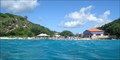
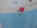 view gallery view gallerySE31.4 km |  You Are Here - Mega Pier - Willemstad, Curacao You Are Here - Mega Pier - Willemstad, Curacao
in 'You Are Here' Maps A very convenient you are here map at Mega Pier orients cruise passengers to the city of Willemstad, Curacao. posted by:  neoc1 neoc1 location: Curaçao date approved: 02/17/2018 last visited: 12/23/2018 |
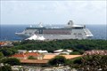 view gallery view gallerySE31.4 km |  Port of Willemstad, Curacao Port of Willemstad, Curacao
in Cruise Ship Ports Willemstad -- the capital of Curacao -- is split in two by a deep narrow channel. Cruise ships dock on the West side of the channel, while the opposite side is the main shopping and business area. posted by: Raven location: Curaçao date approved: 03/19/2013 last visited: 02/20/2022 |
|