|
 Dry Falls Visitor Center - Coulee City, WA Posted by:  T0SHEA T0SHEA
N 47° 36.394 W 119° 21.885
11T E 322267 N 5275282
In central Washington, Grand Coulee was once the site of the world's largest waterfall.
Waymark Code: WMZTX9
Location: Washington, United States
Date Posted: 01/05/2019
Views: 2
At the end of the last ice age, huge lakes formed behind dams of ice, eventually breaking through the dams, releasing their water in vast floods. One of the most notable of these was Glacial Lake Missoula, which, when it unleashed its water, flooded a large portion of Washington and Oregon states. The huge volume of water, travelling at up to 60 miles per hour, scoured the countryside, carving out many large valleys and canyons, the Grand Coulee being one.
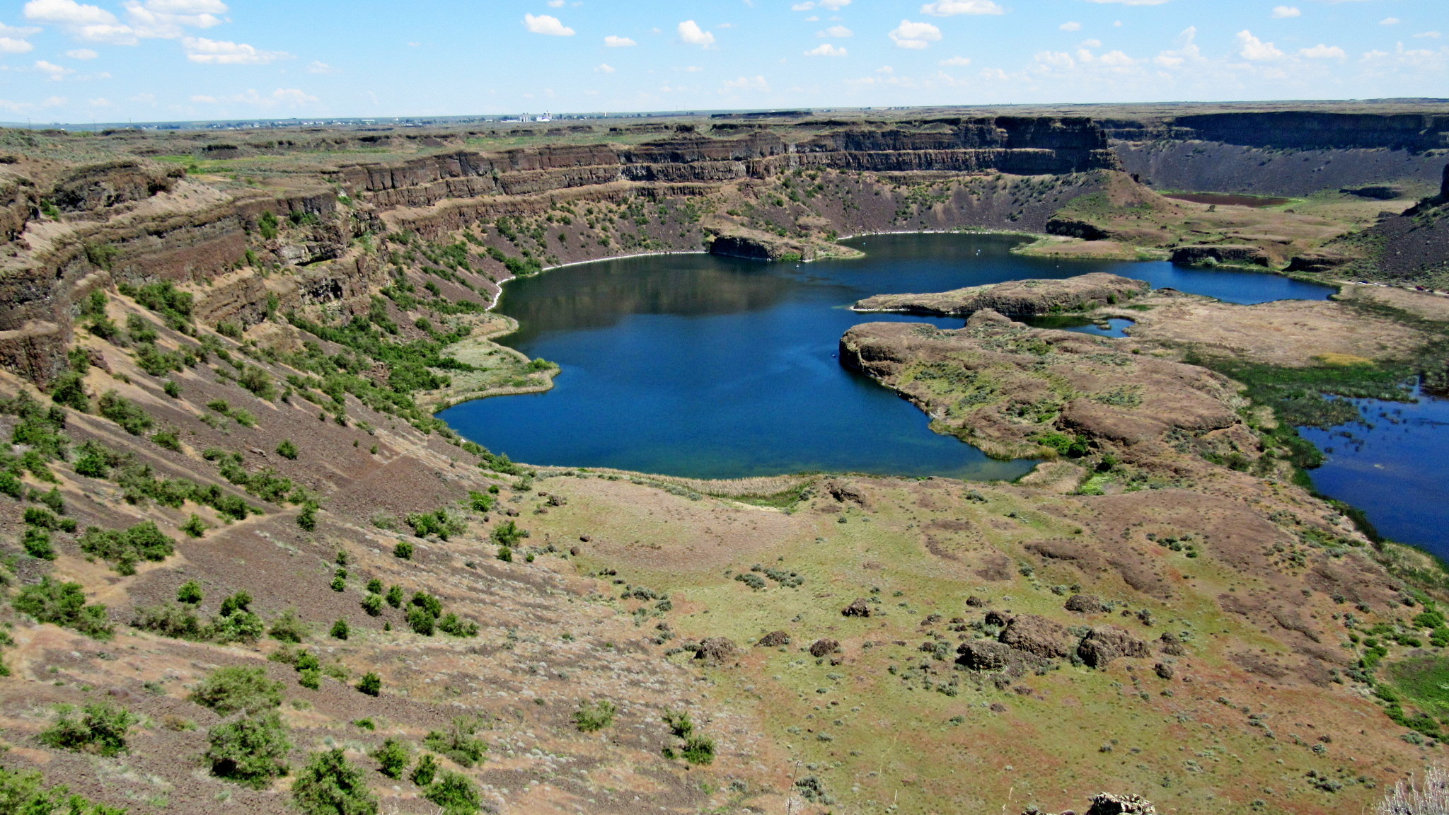
One of the more notable features left by the floods is Dry Falls in Washington's Grant County. A 3.5-mile wide and 400-foot tall waterfall, it is shown in the photo below. Surrounding Dry Falls is Dry Falls State Park. As well as a showcase of natural wonder, this is a recreational park, a 3,774-acre camping park with 73,640 feet of freshwater shoreline and 15 miles of hiking trails.
In the park is the Dry Falls Visitor Center, an interpretive centre relating the story of the creation of Dry Falls and Grand Coulee itself. Within are several plaques and signs telling the Dry Falls story, a diorama of the local topography, tourism and other informational brochures and a well stocked gift and souvenir shop. Outside the building's entrance is an ice cream stand which does a landslide business on hot days.
DRY FALLS VISITOR CENTER
In the heart of the Grand Coulee lies one of the natural wonders of North America—the Dry Falls cataract. This 3.5-mile-wide chasm of basalt, with a drop of 400 feet, was left high and dry thousands of years ago as the last of several Ice Age floods swept through the Grand Coulee. This is one of the most extraordinary landscapes to be found along the Ice Age Floods National Geologic Trail.
ENJOY THE ACTIVITIES
Begin your journey with a visit to the historic Vista House Overlook, which offers panoramic views of Dry Falls. The plunge pools surrounding this dormant Ice Age waterfall are now home to a series of tranquil groundwater-fed lakes, an oasis for wildlife.
THE VISITOR CENTER
Next door you will find the Dry Falls Visitor Center, which features indoor exhibits highlighting the Ice Age and early human history of the region. The center also features a comprehensive bookstore—a must stop for those looking to learn more about the Ice Age floods story.
After visiting the center, explore the Dry Falls landscape by car, on foot, or by boat. Sun Lakes-Dry Falls State Park offers a wide variety of recreational opportunities, including hiking more than 15 miles of trails, interpretive programs, camping, boating, golfing, and wildlife viewing.
ADMISSION
The Discover Pass is required for parking. Admission into the center is free, with donations accepted.
From The Visitor Centre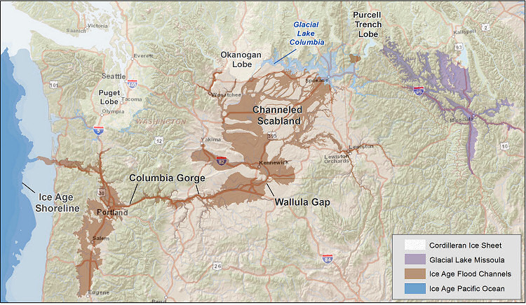
Hours of Operation:
April - September - Open 7 days a week
9 a.m.- 6 p.m.
October 1-31 - Monday - Thursday
9 a.m. - 4 p.m., closed from 1 - 2 p.m.
Winter
Friday - Sunday - 9 a.m. to 4 p.m.

Public Washrooms: Mens, Womens, Family and Handicapped
Snacks/Drinks at the facility: Yes - Store or similar
|
Visit Instructions:As a suggestion for your visit log, please make every effort to supply a brief-to-detailed note about your experience at the Waymark. If possible also include an image that was taken when you visited the Waymark. Images can be of yourself, a personal Waymarking signature item or just one of general interest that would be of value to others. Sharing your experience helps promote Waymarking and provides a dynamic history of your adventures.
Recent Visits/Logs:
| There are no logs for this waymark yet. |
|
|
|
|