|
 Sun Lakes-Dry Falls State Park - Coulee City, WA Posted by:  T0SHEA T0SHEA
N 47° 36.435 W 119° 21.809
11T E 322365 N 5275355
In central Washington, Grand Coulee was once the site of the world's largest waterfall.
Waymark Code: WMZTX6
Location: Washington, United States
Date Posted: 01/05/2019
Views: 1
At the end of the last ice age, huge lakes formed behind dams of ice, eventually breaking through the dams, releasing their water in vast floods. One of the most notable of these was Glacial Lake Missoula, which, when it unleashed its water, flooded a large portion of Washington and Oregon states. The huge volume of water, travelling at up to 60 miles per hour, scoured the countryside, carving out many large valleys and canyons, the Grand Coulee being one.
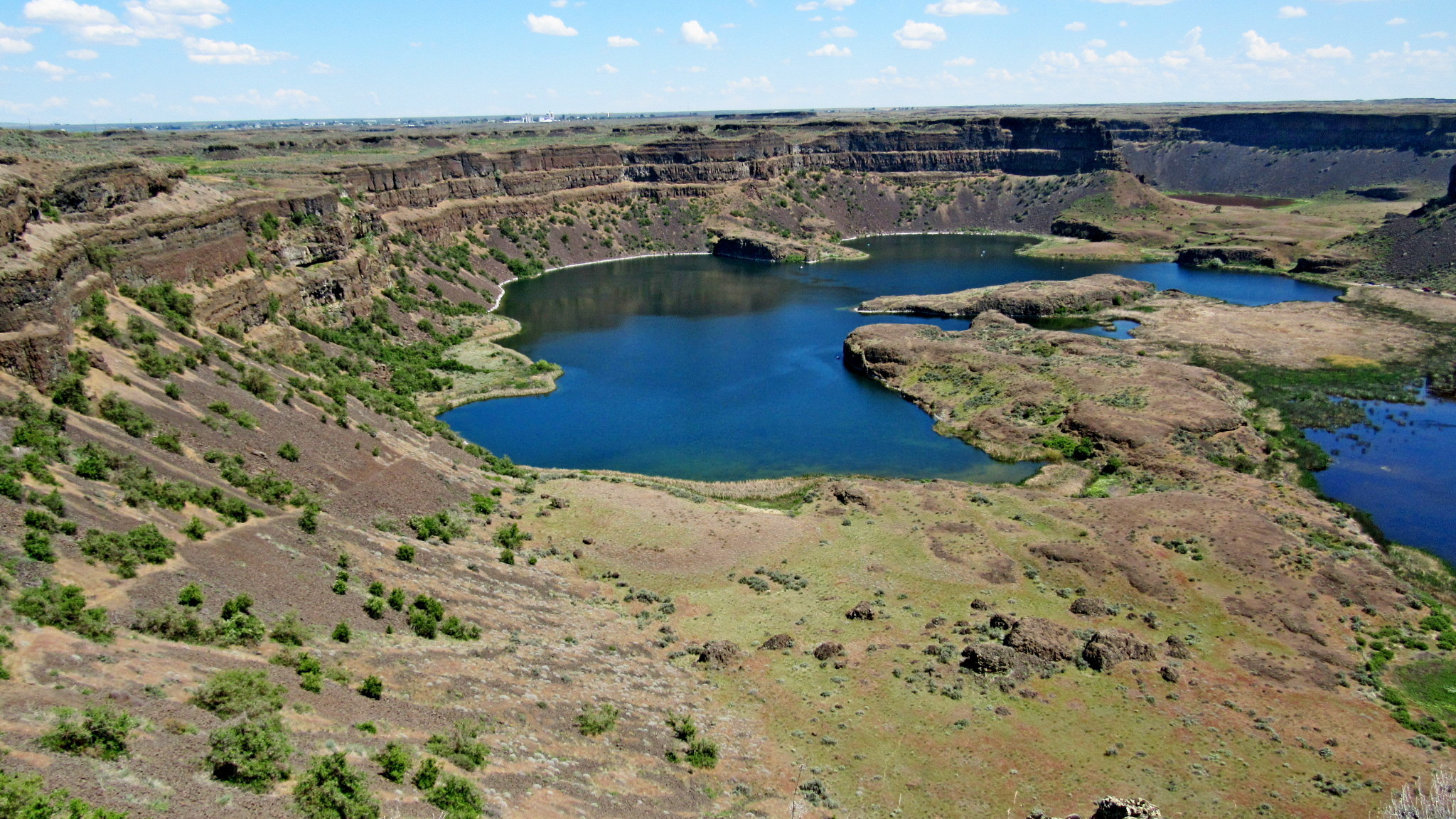
One of the more notable features left by the floods is Dry Falls in Washington's Grant County. A 3.5-mile wide and 400-foot tall waterfall, it is shown in the photo below. Surrounding Dry Falls is Dry Falls State Park. As well as a showcase of natural wonder, this is a recreational park, a 3,774-acre camping park with 73,640 feet of freshwater shoreline and 15 miles of hiking trails.
The place to view Dry Falls is from either in or near this stone gazebo, also known as Vista House, which was built near the rim of the gorge, overlooking it. The "Then" photo of Vista House, judging by the car behind it, is from the early 1930s, while the "Now" photo is from our visit in May of 2018. Both were taken from southwest of the gazebo, looking northeast.
For full information on the park, see the Printable park brochure.
ACTIVITIES |
TRAILS
- 15 miles of hiking trails
|
WATER ACTIVITIES & FEATURES
- 680 feet of dock
- Boating
- Fishing (freshwater)
- Fish cleaning station
- Personal watercraft use
|
- Playground
- Swimming
- Watercraft launches (2)
- Waterskiing
|
OTHER ACTIVITIES & FEATURES
- Amphitheater
- Bird watching
- Commissary
- Fire circle
- Golf
|
- Horseshoe pits (2)
- Interpretive activities
- Mountain biking
- Museum
- Wildlife viewing
|
INTERPRETIVE OPPORTUNITIES
The visitor center at Dry Falls tells the story of this amazing geological phenomenon. From lava flows to the Ice Age floods, and from the Native American legacy to the modern discovery of how Dry Falls was created, the Dry Falls story is revealed to tens of thousands of visitors each year. A gift shop in the visitor center has a wide selection of books, maps, guides, videos, postcards, film, and other merchandise about Dry Falls and the surrounding area. At the end of your visit you will want to spend time looking through the wall of windows over the precipice, as it is magnificent. Please note that a donation helps support the operation of the center. Throughout the park, roads and trails will take you to other fantastic views of geologic features and bring you closer to the desert plants and animals. Take time to make your own discoveries and create your own explanations for what you see. If you had been J Harlen Bretz, would you have come up with such an "outlandish" theory as huge Ice Age floods? The Grand Coulee, of which Dry Falls is a central feature, has been designated as a National Natural Landmark by the National Park Service. As you drive or hike through the Grand Coulee, please do your part to help preserve this national treasure. Admission is by donation.
From Dry Falls State Park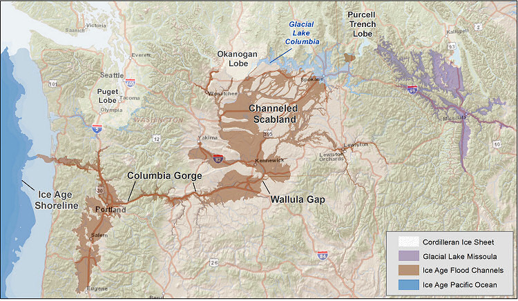
Park Type: Day use, camping and recreational

Activities:
See above
Park Fees:
Discover Pass - Annual pass: $30 • One-day pass: $10
Additional fees for camping, posted at campsites.
Background:
The park stands at the foot of one of the greatest geological wonders in North America. Carved by Ice Age flood and known as “Dry Falls,” this natural monument is the site of a staffed visitor center. The surrounding area is full of beautiful natural formations.
Sun Lakes was originally called Dry Falls but was renamed at the request of then Lt. Governor, Vic Myers, as being descriptive of the area. In 1998, there was a Commission action to restore the words “Dry Falls” officially back into the park name.
Sun Lakes-Dry Falls State Park was acquired in 15 parcels beginning in 1933 and ending in 2002. The parcels were acquired from the Bureau of Land Management, Department of Natural Resources and private ownership.
From The Park
Date Established?: 1933
Link to Park: [Web Link]
Additional Entrance Points: Not Listed
|
Visit Instructions:
To log a visit to a waymark in this category, please include the following ...
1. A picture you took at the park.
2. Your favorite activity at the park.
3. How do you like the park.
Recent Visits/Logs:
| There are no logs for this waymark yet. |
|
|
|
|