|
 Forêt domaniale d'Hardelot - Hardelot, France Posted by:  pmaupin pmaupin
N 50° 38.713 E 001° 38.722
31U E 404224 N 5611248
[EN] The forest of Hardelot is an old royal forest became well from the State to the Revolution.
[FR] La forêt domaniale d’Hardelot est une ancienne forêt royale devenue bien de l’Etat à la Révolution.
Waymark Code: WMX7BZ
Location: Hauts-de-France, France
Date Posted: 12/07/2017
Views: 3

 The forest of Hardelot stretches south of the Creek Ecames, close to the coast of La Mancha and the seaside resort of Hardelot-Plage. It is one of the main wooded sites of the Opal Caps and Marsh Regional Nature Park. Located on a low plateau and gently undulating, at the interface between the bocage of Boulonnais and the dunes of Ecault, it plays an important role in the landscape of the region. The forest of Hardelot stretches south of the Creek Ecames, close to the coast of La Mancha and the seaside resort of Hardelot-Plage. It is one of the main wooded sites of the Opal Caps and Marsh Regional Nature Park. Located on a low plateau and gently undulating, at the interface between the bocage of Boulonnais and the dunes of Ecault, it plays an important role in the landscape of the region.
The oceanic climate and loamy soils are favorable to hardwoods. The stands have many species, often mixed, dominated by Oak and Ash.
Easily accessible by the RD 940 and A 16, Hardelot forest has regular attendance, reinforced in summer by the tourism activity of the region. The castle of Hardelot, nearby, gave it its name.
Parking and picnic areas are located on the outskirts of the massif and along the roads that cross it. Everyone can easily enjoy a moment of relaxation in the shade of the foliage.
Sources : The Forest
 La forêt domaniale d'Hardelot s'étend au sud du ruisseau d'Ecames, à proximité immédiate du littoral de La Manche et de la station balnéaire d'Hardelot-Plage. C'est l'un des principaux sites boisés du Parc naturel régional des Caps et Marais d'Opale. Située sur un plateau peu élevé et faiblement vallonné, à l'interface entre le bocage du Boulonnais et les dunes d'Ecault, elle joue un rôle important dans le paysage de la région. La forêt domaniale d'Hardelot s'étend au sud du ruisseau d'Ecames, à proximité immédiate du littoral de La Manche et de la station balnéaire d'Hardelot-Plage. C'est l'un des principaux sites boisés du Parc naturel régional des Caps et Marais d'Opale. Située sur un plateau peu élevé et faiblement vallonné, à l'interface entre le bocage du Boulonnais et les dunes d'Ecault, elle joue un rôle important dans le paysage de la région.
Le climat océanique et les sols limoneux sont favorables aux feuillus. Les peuplements comptent de nombreuses essences, souvent mélangées, où dominent le Chêne et le Frêne.
Facilement accessible par la RD 940 et l'A 16, la forêt d'Hardelot connaît une fréquentation régulière, renforcée en été par l'activité touristique de la région. Le château d'Hardelot, à proximité, lui a donné son nom.
Des parkings et aires de pique-nique sont aménagés en périphérie du massif et le long des routes qui le traversent. Chacun peut ainsi profiter facilement d'un moment de détente à l'ombre des frondaisons.
Sources : La Forêt
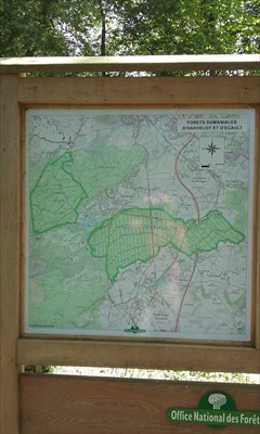
Estimated size of the public land (in regional measurement standard: hectares, acres, kms, etc.): 621 hectares

Is there a trail system?: Yes
If there is a trail system, please describe length, terrain, etc.:
the Converserie Trail (15 km), the Castle Trail (14 km)
What points of interest are there?:
the castle of Hardelot, today the Anglo-British center of the Entente Cordiale, was erected in the 9th century and transformed in the 13th century.
What activities are available?:
The massif is also open to mountain bikes and riders. The equestrian centers around allow beautiful walks in the undergrowth and in the dunes, over 15 km of routes listed.
Hours of accessibility?: 24/24
List of known hazards (cliffs, snakes, poison plants, etc.):
No danger except during hunting season
Dogs Allowed?: Yes
Is a permit/fee required?: No
If a permit/fee is required please describe in detail how to get one, how much, etc.:
Free access
Please supply the website of the land if available: [Web Link]
|
Visit Instructions:
Visitors are encouraged to supply a picture of either themselves or their GPS at the trailhead and/or signage of the public access lands - describe your experience there and what you saw - tell us why other folks should come visit!
|