[EN] Throughout its history, the Audomarois Marsh has experienced numerous flooding episodes. Photographs and press documents bear witness to the significant floods of the past.
Among the major floods, the flooding of the winter of 1974-1975 resulted in agricultural losses exceeding several million francs.
During the flooding of December 1999, the water rose 60 cm in the channel at Grand Gabarit, forming an artificial lake covering the whole of the Marais Audomarois and causing a lot of material damage.
The Marsh was almost entirely covered with water (3,400 hectares). The crops and roads were flooded. More than 50 houses are flooded in St Omer. In Clairmarais, a break in the dike led to the evacuation of 15 dwellings.
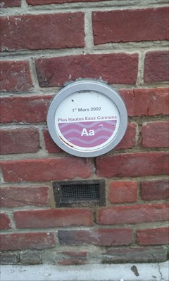
The flooding of 1 March 2002 corresponds to the highest known flow of Aa (57.6 m3 / s measured in Wizernes). This has resulted in a historic rise in water levels in the marsh and the flooding of hundreds of homes and much of the farmland.
Simultaneously, a large flood of the Lys took place and the public authorities had to carry out an exceptional load shedding towards the marsh by Fontinettes lock, according to the protocol set up between VNF, the Pas-de-Calais prefecture, Prefecture Region and local institutions.
[FR] Au cours de son histoire, le Marais Audomarois a connu de nombreux épisodes d’inondation. Des photographies et documents de presse témoignent des crues significatives du passé.
Parmi les inondations marquantes, l’inondation de l’hiver 1974-1975 a généré des pertes agricoles dépassant plusieurs millions de francs.
Durant l’inondation de décembre 1999, l’eau est montée de 60 cm dans le canal à Grand Gabarit, formant un lac artificiel couvrant la totalité du Marais Audomarois et provoquant de nombreux dégâts matériels.
Le Marais s'est trouvé presque entièrement recouvert d'eau (3 400 hectares). Les cultures et les routes se sont trouvées inondées. Plus de 50 maisons sont inondées à St Omer. A Clairmarais, une rupture de digue a entraîné l'évacuation de 15 habitations.
L’inondation du 1er mars 2002 correspond au plus fort débit connu de l’Aa (57,6 m3/s mesuré à Wizernes). Ce phénomène a eu pour conséquence une hausse historique du niveau d'eau dans le marais et l’inondation de centaines d’habitations ainsi que d’une grande partie des terres agricoles.
Simultanément une crue de forte ampleur de la Lys a eu lieu et les pouvoirs publics durent procéder à un délestage exceptionnel vers le marais par l'écluse de Fontinettes selon le protocole mis en place entre VNF, la préfecture du Pas-de-Calais, la Préfecture de Région et les institutions locales.