City Hall - Republic, WA
Posted by: Groundspeak Premium Member T0SHEA
N 48° 38.631 W 118° 44.258
11U E 372003 N 5389322
Built by the CCC in 1933, this has not always been the Republic Town Hall.
Waymark Code: WMRN3P
Location: Washington, United States
Date Posted: 07/11/2016
Published By:Groundspeak Premium Member 8Nuts MotherGoose
Views: 1

Originally built by the Civilian Conservation Corps as the Republic Ranger Station, at some time in the 1970s a new ranger station was built and this building moved to its present location along South Clark Avenue.

The original building on this site was a two-storey store and office building which, under the firm name of John Stack & Company, opened on October 30, 1897, offering an extensive line of general merchandise. Behind town hall, John Stack's old storage building remains standing.

The city hall is Site 33 on the Town of Republic Walking Tour.

Read a bit of the story of Republic further below.

City Hall 1933
Built by CCC as Republic Ranger Station and moved to former location of John Stack's Supply Company in 1970s.
Site 33
From the historical marker over the front door.
Photo goes Here Photo goes Here

HISTORIC REPUBLIC, WASHINGTON

Republic, Washington is a city with an early 1900s look and a heritage based in the mining and logging industries. Founded by gold prospectors, and originally named Eureka Gulch, Republic had a population of 1,073 in 2010. Noted for its fossils, natural beauty and recreational possibilities, it is nestled in a valley between Wauconda and Sherman Passes at the intersection of Washington State Routes 20 and 21 in the north central part of the state.
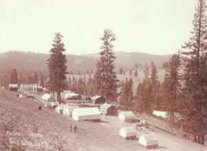
Republic circa 1897 The history of the city and surrounding area can be explored and enjoyed at the Ferry County Historical Center. The center features a collection of historical photos and exhibits that depict the area history and also the Kaufman Cabin – the oldest surviving structure in Republic. Murals at various places around town and historic buildings with historical signs make a walking tour of the city a history lesson in itself.

From the Ferry County Historical Society’s website: “The History of Ferry County’s 110 + years of mining history is based upon its unique geological history and sustained by three major intervals of development. The first was the opening of the Colville Indian Reservation for mining exploration in 1896. Overnight, the mountain and valley rivers and streams rang with the sound of shovels and axes, the braying of pack animals and the feverish invasion of eager men struggling to withdraw hidden wealth from water, rocks and dirt. Gold fever brought in an accompanying wave of entrepreneurs and professional men who saw an opportunity to provide the services needed to build a mining community.”
From the City of Republic
Original Location: N 48° 39.001 W 118° 43.829

How it was moved: Wheels / Dolly / Truck

Type of move: Inside City

Building Status: Public

Related Website: [Web Link]

Visit Instructions:
Tell of your visit. Post an original photograph if possible.
Search for...
Geocaching.com Google Map
Google Maps
MapQuest
Bing Maps
Nearest Waymarks
Nearest Relocated Structures
Nearest Geocaches
Create a scavenger hunt using this waymark as the center point
Recent Visits/Logs:
There are no logs for this waymark yet.