
Humphreys’ Division served as a member of the Third Corps in the Army of the Potomac. The division is honored by two monuments, one  monument at the Peach Orchard, southwest of this position and this one on Sickles Avenue. The division was commanded by Andrew Atkinson Humphreys (November 2, 1810 – December 27, 1883), a career United States Army officer, civil engineer, and a Union General in the American Civil War. He served in senior positions in the Army of the Potomac, including division command, chief of staff, and corps command, and was Chief Engineer of the U.S. Army. After the war, Humphreys commanded the District of Pennsylvania. He became a permanent brigadier general and Chief of Engineers in 1866, a position he held until June 30, 1879, when he retired, serving during this period on lighthouse and other engineering boards. In retirement, Humphreys studied philosophy. He was one of the incorporators of the National Academy of Sciences. He also wrote personal accounts of the war, published in 1883: From Gettysburg to the Rapidan and The Virginia Campaign of '64 and '65. He died in Washington, D.C., and is buried there in the Congressional Cemetery.
The Humphreys' US Division Marker (2), also known as the Army of Potomac 3rd Corps 2nd Division (2) Tablet, is located on Sickles Avenue, on the right or southeast side of the road if traveling north northeast. The tablet is 325 feet southwest of the Emmitsburg Road intersection, a turn of about 30°/150°. The tablet faces west in the direction of the once attacking Confederates. 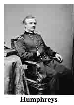 Parking is available roadside at intermittently enlarged shoulders. This area is one way so parking is a snap anyways. Be sure to keep vehicles off the grass or you will be ticketed by park police. I visited this monument on Thursday, July 5, 2012 at 4:02 P.M. I was at an elevation of 598 feet, ASL. I used a Canon PowerShot 14.1 Megapixel, SX210 IS digital camera for the photos.
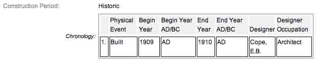
Draw the Sword, with descriptive help from the NPS site, offers the following description: Monuments are rough-hewn monoliths, 4 feet 2 inches x 2 feet x 7 feet in height, consisting of Winnsboro, South Carolina granite. Bronze inscription tablet, 3 feet 8 inches x 3 feet 6¾ inches, is affixed to the polished face of the monolith. Corps insignia, a bronze Maltese Cross, is excised & polished at top of tablet. One of 22 Union division monuments that describe the movements and itinerary of each division of the Army of the Potomac. Designed by E. B. Cope. The Maltese cross symbol of the Fifth Corps appears at the top of the tablet, just above the main inscription, on a separate piece of metal. The inscription on this tablet reads:
 Army of the Potomac
Third Corps
Second Division
Brig. General Andrew A. Humphreys
First Brigade Brig. Gen. Joseph B. Carr
Second Brigade Col. William R. Brewster
Third Brigade Col. George C. Burling
July 2. Arrived about 1 a.m. and bivouacked for the night. In the morning took position between Birney's Division on the left and the Second Corps facing Emmitsburg Road. Between 2 and 3 p.m. advanced to the Emmitsburg Road. Carr's Brigade in line along the road. Brewster's Brigade in reserve. Burling's Brigade at first in reserve and then except the 5th New Jersey sent to Gen. Birney. The Division was attacked by McLaws's and Anderson's Division and by sunset was compelled to retire to the first position occupied where it reformed on the left of Second Corps and drove back the Confederate forces beyond the Emmitsburg Road and recovered the Artillery that had been abandoned and captured many prisoners and held the position during the night.
July 3. About sunrise moved to the rear and left and was supplied with rations and ammunition. Burling's Brigade joined the Division moved to different points in rear of the First, Second, Fifth, and Sixth Corps in support of threatened positions. Suffered some loss in the afternoon from Confederate Artillery.
Casualties. Killed 28 officers 286 men. Wounded 140 officers 1422 men. Captured or missing 2 officers 214 men. Total 2092.
There are hundreds of non-sculpted monumentation for the various Regular Union (Army of the Potomac - Federals) units & "Regular" Confederate units engaged at Gettysburg from July 1-3, 1863. There are about 10 different variations of tablets, markers & monoliths by my reckoning. Six designs represent brigade (2), division (2), corps (2), & army headquarters (only 2), each different in a subtle way so as to distinguish between armies. Battalion/battery/advance position markers & regimental monuments for U.S. Regulars & Confederate have their own distinct design (2), bringing the total to 10 designs at the battlefield. The bronze tablets (these ones, too) were created by Albert Russell & Sons Co. of Newburyport, Mass. The granite bases which accompany the various tablets were created by the Van Amringe Company from Boston, Mass. The cast iron tablets were manufactured by Calvin Gilbert. The 1910 Gettysburg Commission report lists the awarded contracts to these companies (not Gilbert) for the tablets. All of these tablets were designed by architect Colonel Emmor Bradley Cope (July 23, 1834 - May 28, 1927). He designed pretty much every tablet for both the Union & Rebel armies, each one distinct, w/ several different varieties. He is buried in Evergreen Cemetery in Gettysburg, as well he should be as this park and most of the things seen here today were designed by him and as such, are his legacy. These monuments were erected just after the turn of the century during the first & beginning of the second decade of the 20th century. Each one has since been preserved or restored at least twice since the turn of the 21st century. The plaques & tablets were erected by the Gettysburg Park Commission (established by the War Dept.), after they took over the administration of the park from the Gettysburg Battlefield Memorial Association (whose funds had expired) on March 3, 1893, and whose stewardship was then transferred to the National Park Service in 1933) SOURCE The Gettysburg Park Commission is also referred to as the Gettysburg National Military Park Commission or the Gettysburg National Park Commission, to clear up any confusions, especially my own.
On October 1, 1898, the Gettysburg National Park Commission in a letter to the Secretary of War set gave recommendations for continuing the task of organizing & progressing the work of the Gettysburg National Military Park. Every November they wrote their annual report which outlined the work of the GNPC for that year. The following is an excerpt from that report relevant to this waymark. The link at the end of the paragraph will take you to the entire report. The method of marking the positions of troops on this field, as approved by the War Department, is to place the principal tablet or monument of each command at the position occupied by the command in the main line of battle, and to mark the several important positions subsequently reached by each command in the course of the battle by subordinate and ancillary tablets, with appropriate brief inscriptions giving interesting details and occurrences and noting the day and hour as nearly as possible. SOURCE
Most of the Commission reports have been digitized and can be found HERE. The initial 1893 report up to & including 1921 can be found here. 1922 to 1926 are missing & have yet to be discovered. The years 1927 to 1933 were discovered in 1996 and are also included. To my knowledge this is the most comprehensive list of documents that illustrated the development and formation of the park.
Information about these specific types of monuments:
DIVISION HEADQUARTERS MARKERS (For Union & Confederate Monuments)
Division headquarters are rectangular bronze tablets mounted on large, rectangular stones. Union headquarters have a corps or service branch symbol (like a cross, clover, star or crescent moon) as a separate bronze piece above the tablet (this one has the Maltese cross), while Confederate headquarters are labeled "C.S.A." on a separate bronze piece in an oval. There are 22 Union and 10 Confederate Division markers at Gettysburg. Both markers are of similar design and were all construed of Winnsboro (S.C.), granite. Each stands seven feet in height. SOURCE & SOURCE
The Humphreys' US Division Marker (2) is a contributing feature to the Gettysburg Nat'l Military Park H.D. which is nationally significant under NR Criteria A, B, C & D. Areas of Significance: Military, Politics/Gov't, Landscape Architecture, Conservation, Archeology-Historic. Period of Significance: 1863-1938. The monument is designated as structure no. MN434.
From the Nomination Form:
1 of 23 Civil War US Division Tablets in Park. Records movements & itinerary of 3 Corps, 2 Division which was commanded by Brig. General Humphreys.
Short Physical Description:
Rough-hewn monolith, 4'2"x2', 7' high. Bronze inscription tablet, 3'8"x3'6 3/4" mounted on polished face of monolith. Diamond-shaped bronze corps insignia attached above tablet.
Long Physical Description:
Located on E side of North Sickles Avenue, Klingel Farm.
My Sources
1. NRHP Nomination Form
2. Stone Sentinels
3. Virtual Gettysburg
4. Draw the Sword
5. Historical Marker Database
6. Wikipedia