|
 Rohrbaugh Plains Trail - Dolly Sods Wilderness- Monongahela National Forest - Dry Run, West Virginia
N 38° 58.557 W 079° 20.246
17S E 644018 N 4315422
The Rohrbaugh Plains Trail of the Dolly Sods Wilderness of the Monongahela National Forest and is located off of Forest Road 75 in Grant County, West Virginia.
Waymark Code: WMER4J
Location: West Virginia, United States
Date Posted: 06/30/2012
Views: 2
Rohrbaugh Plains Trail– Dolly Sods Wilderness – Monongahela National Forest – Dry Run, West Virginia
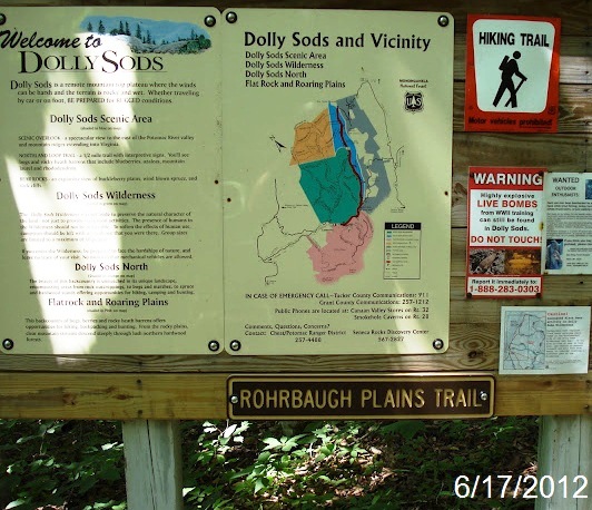
This is one of several trailheads in the Dolly Sods Wilderness of the Monongahela National Forest.
The 17,371 acre Dolly Sods Wilderness in the Monongahela National Forest is part of the National Wilderness Preservation System. It is located in Grant, Randolph and Tucker Counties, West Virginia. The Dolly Sods Wilderness contains much of the Red Creek drainage and contains bog and heath eco-types, more commonly typical to southern Canada. Elevations range from 2,500 to over 4,700 feet.
Dolly Sods Wilderness has 47 miles of trails, many of which follow old railroad grades and logging roads. Listed below are several possible loop hikes. Fords indicate streams that may be a problem to cross during high water events. There may be additional small stream crossings.
- Practice Leave No Trace outdoor ethics: do not build a camp within 200 feet of roads, streams and trails.
- Trails can be muddy and wet so be prepared to get your feet wet.
- Dress for the weather. Be prepared for sudden changes.
- Wear proper footwear.
- Bring drinking water; otherwise, treat water from streams and springs before drinking to kill harmful pathogens.
- During hunting seasons, hikers are encouraged to wear high visibility clothing
NOTICE
Beginning in August of 1943, the military used the area for maneuvers and mountain training for World War II. Many of the artillery and mortar shells shot into the area for practice still exist. In 1997, a highly trained crew surveyed the trail locations and known campsites for shells. They found 15, some of which were still live. All were exploded on site. Many more may exist and they are dangerous. Since it is impossible to survey every acre of the wilderness, we ask that you follow the recommendations below for your own safety.
- Stay on designated trails.
- Do not create new trails.
- Camp at existing campsites. These usually have a fire ring and show bare ground around them.
- If you camp at a place without a fire ring DO NOT create one. Use a backpacker-type stove for your cooking needs and enjoy a night without a campfire.
About the Trail
This trail proceeds three miles through the Rohrbaugh Plains of the Dolly Sods, the Wildlife Trail branches off and Rohrbaugh finaly connects to the Red Creek Trail
Trailhead/trail website: [Web Link]

Trail allowances or restrictions:
Groups over 10 persons are prohibited in the Wilderness.
Camping and open campfires are prohibited within 300 feet of Forest Road 19 and Forest Road 75.
Pets must be under your control at all times.
Motor vehicles are restricted to roads and parking areas.
Mountain bikes and mechanical devices such as carts are not allowed on Wilderness trails.
Trail type: Dirt/Grass
Parking: Not Listed
|
Visit Instructions:
To claim a log for this waymark, some proof of a visit is required. This proof could be a simple photo of their GPS at the trailhead, a photo of the person at the trailhead, or a photo of a signature item that a person uses for photographs, at the trailhead.
In order to help other waymarkers who are looking for a nice hike/walk outdoors, you are encouraged to provide good feedback about the quality of the hike/trail.
Recent Visits/Logs:
| There are no logs for this waymark yet. |
|
|
|
|