
KCT: Na Ždárku, Jizerské hory, CZ
Posted by:  Ursus PiPa
N 50° 50.609 E 015° 12.604
33U E 514790 N 5632440
Rozcestník turistického znacení Klubu ceských turistu. Nachází se na úbocí Hejnického hrebene v Jizerských horách. /// This signpost is a part of trailblazing of the Czech Hiking Club. It is located on the hillside of the Hejnice ridge.
Waymark Code: WMEG06
Location: Liberecký kraj, Czechia
Date Posted: 05/24/2012
Views: 73
CS:
- zelená znacka vedoucí z Nového Mesta pod Smrkem pres
Sedlo Holubníku až do
Kristiánova
- žlutá znacka spojující rozcestí „Cihadla“ s
vodopádem Velkého Štolpichu
|
SYSTÉM
TURISTICKÉHO ZNACENÍ V CESKÉ REPUBLICE
-
Systém turistického znacení je chloubou Klubu Ceských Turistu.
-
Jeho základem je tzv. pásové znacení používající ctyri barvy – cervenou, zelenou, modrou a žlutou. Typická turistická znacka má podobu ctverce ze trí pruhu. Prostrední pruh má barvu turistické trasy, vrchní a spodní pruh jsou bílé.
|
 Cervená znacka slouží pro dálkové trasy a stezky vedoucí po horském hrebeni.
|
|
 Modre jsou znaceny významnejší trasy.
|
|
 Zelená barva je vyhrazena pro trasy místního významu.
|
|
 Žlute se obvykle znací spojovací trasy a jiné kratší cesty.
|
-
Vyjma tohoto základního znacení existují i znacky pro cyklisty (znacky mají žluté orámování
 ) a lyžare (znacky mají oranžové orámování). ) a lyžare (znacky mají oranžové orámování).
Zvláštní znacky se používají pro jezdecké stezky (barevný proužek je nahrazen barevným koleckem), naucné stezky a místní vycházkové okruhy.
-
Doplnkem pásových znacek jsou tvarové znacky, které upozornují na zajímavá místa ležící v blízkosti turistických tras.
-
Znacky spojují turistické cíle a duležité križovatky napríc celou Ceskou republikou.
Na križovatkách a u významných orientacních bodu doplnují znacky
smerovníky (neboli rozcestníky) s místním pojmenováním a
ukazateli informujícími o vzdálenosti dalších míst v okolí.
|
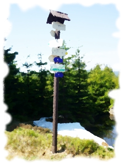
EN:
-
Green marked hiking path from Nové Mesto pod Smrkem. This trail leds via the saddle of Holubník to the village called
Kristiánov.
- Yellov marked hiking trail connecting the crossroads „Cihadla“ with the
Great Štolpich waterfall.
|
THE
NATIONAL SYSTEM OF TRAILBLAZING IN CZECH REPUBLIC
-
The national system of trailblazing is boast of the Czech Hiking Club (KCT).
-
The base of this system consists of colored hiking trails - red, green, blue and
yellow.
The path's colour will be marked throughout the path by three short horizontal
stripes - the outer two are white and the innermost the colour of the path you are on.
|
The red marks is usually used for long-distance trails and paths leading over the mountain
ridges.
|
|
Other important hiking trails are marked by the blue marks.
|
|
Green color is used for the trails with local importance.
|
|
Yellow signs is usually used for shortcuts and other shorter
trails.
|
-
In addition to the basic trailblazes other special signs exist. Tourist signs with yellow border (used for cyclo routes) and signs with orange border (used for ski routes).
Specific forms of signs are used for horseback riging trails (color strip is replaced by a color wheel), nature trails and local walking circuits.
-
Shaped trailblazes supplement the basic system when a notification of any interesting object located near hiking trails is
necessary.
-
Tourist signposts (such as the waymarked) stand next by important landmarks and mainly at intersections of hiking trails. These signposts consist of sign with name of the place and direction signs pointing to other intersections of hiking
trails.
|
Historic significance:
CS:
Postaveno Českým klubem turistů (KČT) jako součást značení turistických tras.
///
EN:
Built by Czech Hiking Club (KČT) as a part of the hiking trails.

Location nearest to where you live now:
Kristiánov : 4.5 km
Date placed: Not listed
|
Visit Instructions:
To log an existing waymark in this category, please describe why you visited this marker, provide a photograph of the marker (preferably with yourself or a friend) of the marker, and list the "arrow" that comes closest to where you live now.