
Spangler's Spring - Gettysburg, PA
N 39° 48.878 W 077° 13.028
18S E 310226 N 4409535
One of the really neat & unique Civil War sites referenced not only in the American Guide Series & Wikipedia but countless other historical documents and reference material. Spangler's Spring provided fresh water for both sides of the conflict.
Waymark Code: WMC8BR
Location: Pennsylvania, United States
Date Posted: 08/07/2011
Views: 11

On the second day the Union line was in the form of a great fishhook about three miles long, with the barb at Spangler's Spring, the bend at Culp's Hill and Cemetery Hill, the shank along Cemetery Ridge, and the eye at Round Top. --- Pennsylvania: A Guide to the Keystone State, 1940; page 229.
The spring is actually sealed off and has a NPS lock on it. The stone work surrounding it, historic markers attached and spring itself are together a contributing structure to the historic district. One of the markers reads One Country and One Flag the Strife of Brothers is Past and the other plaque reads This Spring Supplies Union and Confederate Soldiers with Water During the Battle. At the top of the curved stone is a bronze marker which simply reads Spangler's Spring.
Spangler's Spring is a natural spring southeast of Gettysburg on the south base of Culp's Hill. At times during the batlle it was held by each side, and for a time was between the lines. Legends developed that local truces were called during the night of July 2nd where both sides allowed the other to pass safely to the spring to fill their canteens, but there are also documented instances of fighting around the spring during this time. SOURCE
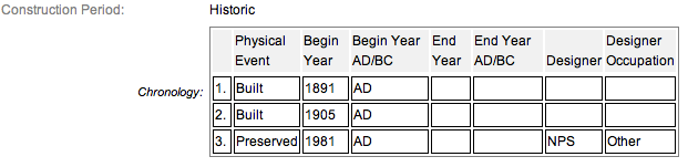
The Spangler Spring Stone Work is a contributing feature to the Gettysburg National Military Park Historic District which is nationally significant under NR Criteria A, B, C & D. Areas of Significance: Military, Politics/Government, Landscape Architecture, Conservation, Archeology-Historic. Period of Significance: 1863-1938. The original National Register Nomination was approved by the Keeper March 19, 1975. An update to this nomination was approved by the Keeper on January 23, 2004. This roadside marker is listed as contributing structure number MN822.
From the NRHP narrative page for this tablet:
One of two natural springs on Spangler Property where Union & Confederate forces refilled their canteens. Other spring was covered in 1878, this spring had granite font built to honor all soldiers of North & South.
Short Physical Description:
Natural spring in rock, War Department constructed font w/in spring boundaries Mar-Apr 1891, completed Oct 1905. Font has apse at back, 7'H x 11'L x 5'W. Built of polished granite w/3 bronze plaques at face. 4'W Conc walk S, runs E-W 20'
My Sources
1.
NRHP Narrative
2.
Stone Sentinels