FAA Identifier: JKA
Elevation: 16 ft. / 4.9 m (surveyed)
Variation: 00E (2000)
Airport use: Open to the public
Sectional chart: NEW ORLEANS
Control tower: no
ARTCC: JACKSONVILLE CENTER
FSS: ANNISTON FLIGHT SERVICE STATION [1-866-609-8684]
NOTAMs facility: ANB (NOTAM-D service available)
Attendance: 0700-2200
Wind indicator: lighted
Segmented circle: no
Lights: DUSK-DAWN
Beacon: white-green (lighted land airport)
Fuel available: 100LL JET-A
Parking: tiedowns
Airframe service: MAJOR
Powerplant service: MAJOR
Bottled oxygen: NONE
Bulk oxygen: NONE
Runway 9/27
Dimensions: 6962 x 100 ft. / 2122 x 30 m
Surface: asphalt, in good condition
Weight limitations: Single wheel: 80000 lbs
Double wheel: 100000 lbs
Runway edge lights: high intensity
Runway edge markings: /27 MARKINGS FADED.
RUNWAY 9 RUNWAY 27
Traffic pattern: left left
Runway heading: 090 270
Displaced threshold: 463 ft. no
Markings: nonprecision, in poor condition nonprecision, in poor condition
Visual slope indicator: 4-light PAPI on left (3.00 degrees glide path) 4-light PAPI on left (3.00 degrees glide path)
Approach lights: MALSR: 1,400 foot medium intensity approach lighting system with runway alignment indicator lights
Touchdown point: yes, no lights yes, no lights
Instrument approach: ILS/DME
Obstructions: 10 ft. brush, 240 ft. from runway, 150 ft. left of centerline, 4:1 slope to clear none
Runway 17/35
Dimensions: 3599 x 70 ft. / 1097 x 21 m
Surface: asphalt, in good condition
Weight limitations: Single wheel: 80000 lbs
Double wheel: 100000 lbs
Runway edge lights: medium intensity
RUNWAY 17 RUNWAY 35
Traffic pattern: left left
Runway heading: 175 355
Markings: basic, in fair condition basic, in fair condition
Touchdown point: yes, no lights yes, no lights
Obstructions: 50 ft. trees, 1650 ft. from runway, 29:1 slope to clear
+8 FT BRUSH 190 FT FROM THLD. 55 ft. trees, 1300 ft. from runway, 20:1 slope to clear
Airport Operational Statistics
Aircraft based on the field: 50
Single engine airplanes: 41
Multi engine airplanes: 8
Jet airplanes: 1
Aircraft operations: avg 224/day
91% transient general aviation
6% local general aviation
3% military
Personal note: Some of those 50 foot trees are probably mine.
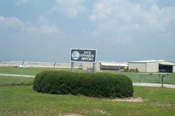
To log this waymark you must include at least two photos of identifiable features of the airport one being of the entrance sign.
To do this you just fill out the form and comments and submit log. On the next page click on View Log.
Now on the right side you have an option to upload an image for this log.
Upload your pictures and they will appear properly.
LOGS WITHOUT PICTURES WILL BE DELETED!!!
You can log this airport only once. Duplicate logs will be deleted.
There are a couple of other local airports you can log: