
34 Miles to Philadelphia - Thorndale, PA
N 39° 59.494 W 075° 46.328
18S E 434082 N 4427106
Part of a series of late 18th century markers which were installed when this, the nation's first major toll road was constructed. Later, this became part of the Lincoln Highway, almost 125 years later.
Waymark Code: WMACQW
Location: Pennsylvania, United States
Date Posted: 12/27/2010
Views: 5
This small, rounded marker is in good condition with just the right side kind of worn away, slightly compromising the number four. It is a couple feet high, tiny compared to others, especially the other one a mile away to the west. It is in the tall grass so it is easy to miss yet when I drive by, it stuck out like a sore thumb. The marker reads:
34 M
To
P
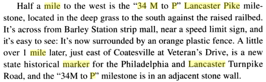
The marker is located on E Lincoln Hwy. (Bus. Rt. 30), south side of the road, across from the one-sided intersection of Barley Sheaf Road, just before the town of Coatesville. This turnpike predates the Lincoln Highway by about one hundred twenty-five years but was eventually included in it. Between Philadelphia and Lancaster, the Lincoln Highway followed Lancaster Pike. When Lancaster Pike was completed in 1795 as one of America’s first toll roads, it connected the largest city on the continent with the largest inland city in America. The crushed stone macadam surface that was state-of-the-art in the early-19th century would still be covering Lancaster Pike in the early-20th, and the tolls would stand until six years after its absorption by the Lincoln Highway. These markers were put in at its completion, or possibly during it. Records about that are sketchy.
The marker is recognized on Google Maps with a green arrow pointing it out. Additionally, it is also feature in one of their pictures. More notoriety was found when I actually found a reference to this marker in a book called Lincoln Highway by Brian Butko on page 77. I made an image of the excerpt, which is below.
There is also a photo album of all the mile makers in the area for miles and miles around which can be found HERE. The actual picture for this marker can be found at this LINK.
Parking is roadside or in the nearby strip mall parking lot.