13 Miles on the Turnpike - Bensalem, PA
N 40° 04.533 W 074° 57.382
18T E 503720 N 4436143
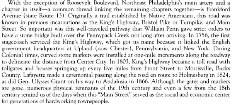
Another historic survey marker is a big gray, tombstone looking miles marker shows the mileage along this historic road. As these stones move further away from Philadelphia in a northeast fashion, their mile marker number increases.
Waymark Code: WMACG3
Location: Pennsylvania, United States
Date Posted: 12/25/2010
Views: 9
Along historic Bristol Pike, just over the Philadelphia border are a couple of these mid to early 19th century road markers established by surveys in the days of horses and buggies. Miraculously, they still survive today. On this particular stone marker, the mileage of 13 T is heavily incised in large, bold strokes. I checked on Google and it exactly 15 miles to Trenton so I think the stone has nothing to do with Trenton. I found another stone about 6 miles away with a new historic marker in front of the stone mile marker explaining the significance of that marker. Because the 19 T marker it is part of this series, I thought it was particularly relevant so I have included the text of it to maybe help explain the significance of this waymark. It reads:
Marker 19T indicates the distance between here and Market St. in Phila along the Phila-Frankford Turnpike to Morrisvile, PA. Road through Bristol was finished in 1810. There is a caveat, which I cannot authenticate, beneath the picture which reads "Note that the stone inscription is incorrect; the mileage for the turnpike is calculated from Front Street near Germantown Ave., not from Market".
I found another one of these, identical, one mile closer to Philadelphia, southwest of here. As a lark, I extended a line from the 12 T, one mile northeast along Route 13 on the Bristol Pike using GoogleEarth, to the 13 T. I marked the spot, went in for a close view and used the street picture feature and what did I see? Why, the 13 T marker of course, exactly where it should be, in front of the fence, placed in the grass on the outskirts of St. Elizabeth Convent, near the entrance.
The 4-foot stone is about 10 feet from Bristol Pike (Route 13). I got curious and extended a line from the location of the marker all the way to the very beginning of Route 13 or the Kings Highway and Lo and Behold, its 13 miles! Aha!, the marker is in its original place and is pretty accurate, indicating the exact highway mileage from the start of the Kings Highway to this point here.
HERE is a fantastic link which lists all the historic markers in the immediate quadrant. I found another source, Lower Northeast Philadelphia By Louis M. Iatarola, Lynn-Carmela T. Iatarola, The Historical Society of Tacony, page 8. Here is an excerpt from the book about the string of markers, including this one, along the Bristol Pike, which apparently, after reading the passage, has many other names as well: