The Missouri River Valley as a Transportation Corridor
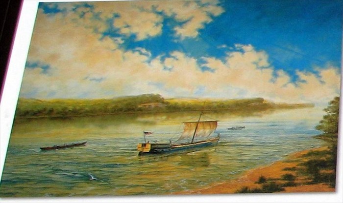
Lewis and Clark, 1804
Shown here are the two pirogues and keelboat used in the Lewis and Clark Expedition for their voyage up the Missouri River. Pirogues were commonly used boats on the western waters. Keelboats, the most advanced type of river craft before the steamboat, had a keel running along the bottom to provide stability. Usually they had a cabin for cargo or passengers.
Before the use of steam, riverboat men had several techniques to get a boat upstream. The easiest was to use sails and wind power. If they could not use wind, the crew would sometimes use poles to push the boat forward. Another method, called cordelling, was to walk along the band and pull the boat with ropes. While going downstream cold be effortless, going upstream was not an easy feat until the advent of the steamboat.
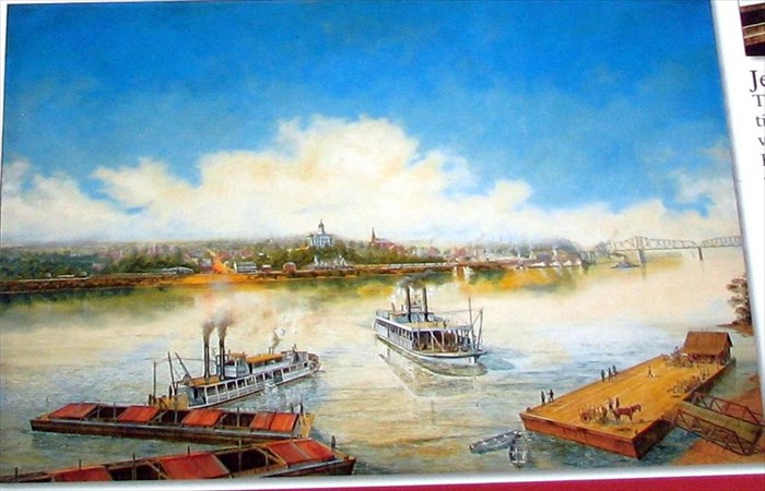
Jefferson City, 1904
As the second image shows, this area changed dramatically in the 100 years since the Lewis and Clark Expedition. In 1821, the new state government picked this site for the state capitol due to its central location and position on the river. Additionally, the 19th century brought two major transportation innovations through the Missouri River corridor -- the steamboat and the railroad.
As trade opened west of Missouri in the 19th century, steamboats brought goods and people through this area. Towns along the Missouri River, such as Jefferson City, became points of distribution for further settlement.
The increased use of railroads, which were cheaper and faster, caused a notable decline in the number of steamboats on the river. By 1856, Pacific Railroad had regular trains running from St. Louis to Jefferson City. Steamboats would meet the trains in Jefferson City and provide transport farther west. The Hannibal and St. Joseph Railroad, completed in 1859, was the first cross-state railroad. The Missouri-Kansas-Texas, or MKT Railroad, ran along much of the Missouri River valley by the 1890s and connected the state with the southwest. Eventually, railroads took over much of the transportation of goods and people until the advent of the automobile.
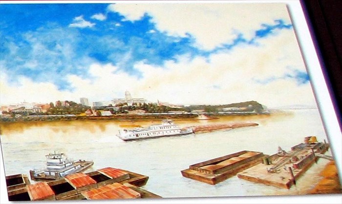
Jefferson City, 2004
The final image, which shows the river corridor in 2004, completes the 200 year span of time. Again, the riverscape had changed dramatically after 100 years. Clearly visible is the newer, larger Capitol building, as well as other large downtown buildings. Barges and tugboats make up most of the river traffic. Trains still carry goods and people through the Missouri River corridor. Katy Trail State Park on the north side of the river is a rail-trail conversion project that makes use of the MKT railroad bed. Riverboats, railroads and Katy Trail enable the public to continue to use the Missouri River valley as a transportation corridor as people have done for centuries. - text of marker