
The Rainey Plantation - GHM 044-8 - DeKalb Co., GA
Posted by:  Lat34North
N 33° 53.110 W 084° 17.082
16S E 751124 N 3752742
The Rainey Plantation State Historical Marker located on the east side of Shallowford Road at Carroll Avenue.
Waymark Code: WM2TAM
Location: Georgia, United States
Date Posted: 12/18/2007
Views: 52
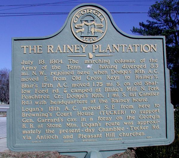 THE RAINEY PLANTATION
July 18, 1864. The marching columns of the Army of the Tennessee [USA] having diverged 5.5 miles North West, rejoined here when Dodge’s 16th A.C. moved East from Old Cross Keys to Rainey’s, Blair’s 17th A.C. moved 1.75 miles South on old Shallow Ford road and camped at Blake’s Mill, North Fork Peachtree Creek; Dodge’s 16th 1 mile South (at Candler Road) with headquarters at the Rainey house.
Logan’s 15th A.C. moved South East from here to Browning’s Court House (Tucker) to support General Garrard’s Cavalry in a foray on the Georgia R.R. at Stone Mountain. Logan’s route was approximately the present – day Chamblee-Tucker Road via Antioch and Pleasant Hill churches.
GHM 044-8 - Georgia Historical Commission - 1954