About 20 km. north of the village of Rock Creek is the Trans Canada Trail Cyclists' Rest Stop, built along the Blythe-Rhone road beginning in 1998 by Paul Lautard, formerly a Rhone resident who now lives in Midway.
The most visible item on the site is a Kettle Valley Railway caboose. Along with the caboose is a collection of railroad memorabilia that has been collected over the years and added to on an "as found" basis.
North of the caboose and the rest stop's shelter is a World War II cenotaph, also created by Paul Lautard. The cenotaph, a 28 tonne rock, surrounded by a cement footing with a Canadian flag beside, bears a bronze plaque commemorating the memory of Rhone residents who served, and who died, in World War II.
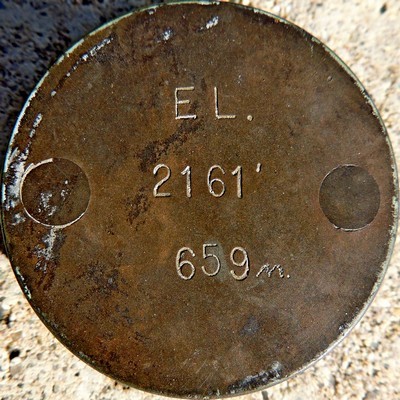
In the southeast corner of the concrete base of the cenotaph is a small bronze disc bearing the elevation of the cenotaph, which happens to be
2161 feet, or
659 metres. This is a type that is new to me. Just when you think you've seen it all. 😊
While traveling around the Boundary looking for advertisers and stories to go into the OpenMinder, I was told about a person who was building a rest stop for the Trans Canada Trail that was being officially recognized. When I phoned to make a time to meet him a couple weeks ago, he said there was still 8 inches of snow on the ground, but I would find him out at the shelter, up on a ladder building and extention on the shelter roof.
Well last week I went out to Rhone Road off of Hwy #33 just past Westbridge to meet Paul Lautard and a warm spell had made it harder to find evidence of the snow, but Paul was up on the ladder when I arrived.
When I got out of my car, the welcoming feeling of this place was overwhelming. The layout of the building, the railroad memorabilia, the cenotaph, picknick tables. Everything was a compliment to each other, and even more impressive is that Paul, who is 76, has done this himself, with his own time, money, land, and a little help from some friends.
There are old signs, spikes, locks, tools, and the 28 ton Granite Rock Cenotaph War Memorial that found its place when the D9 Cat hauling it couldn’t pull it any further. The Cenotaph has a concrete base that boasts the Canadian flag and a bronze plaque commemorating those family members that have passed on with a canister for ashes on the backside.
Paul brought me over to the cenotaph, a 28 tonne rock, surrounded by a cement footing with a Canadian flag and a bronze plaque commemorating the memory of family passed. “The rock picked its place cause the D-9 Cat couldn’t drag it any more” Paul added.
Rhone is located on the Trans Canada Trail at the 25 mile marker from Midway, BC, off Hwy # 33, on Rhone Road just north of Westbridge, BC. The Paul Lautard Cyclist Stop and War Memorial at Rhone was commemorated an official Trans Canada Trail rest stop for the relay. Paul and his dog Stubby started working on this project in 1998. Today it is a FREE stop for cyclists! The stop offers a shelter with picnic tables, water, dutch door outhouse and a
From Kettle Valley Express