
Millennium Murals - Oliver, British Columbia
Posted by:  T0SHEA
N 49° 10.936 W 119° 33.061
11U E 314102 N 5450850
Millennium Murals are located on the front side of the Oliver Archives, facing Fairview Road.
Waymark Code: WM13RB5
Location: British Columbia, Canada
Date Posted: 02/08/2021
Views: 0
OLIVER'S MILLENNIUM MURALS
DESIGNED AND PAINTED BY
TEYA COTY
IN THE YEAR 2000
THIS OLIVER AND DISTRICT HERITAGE
SOCIETY PROJECT WAS FUNDED
THROUGH A DONATION FROM
CYRIL HEADY
AND A 50% GRANT FROM THE
B.C. 2000
MILLENNIUM ARTS & HERITAGE FUND

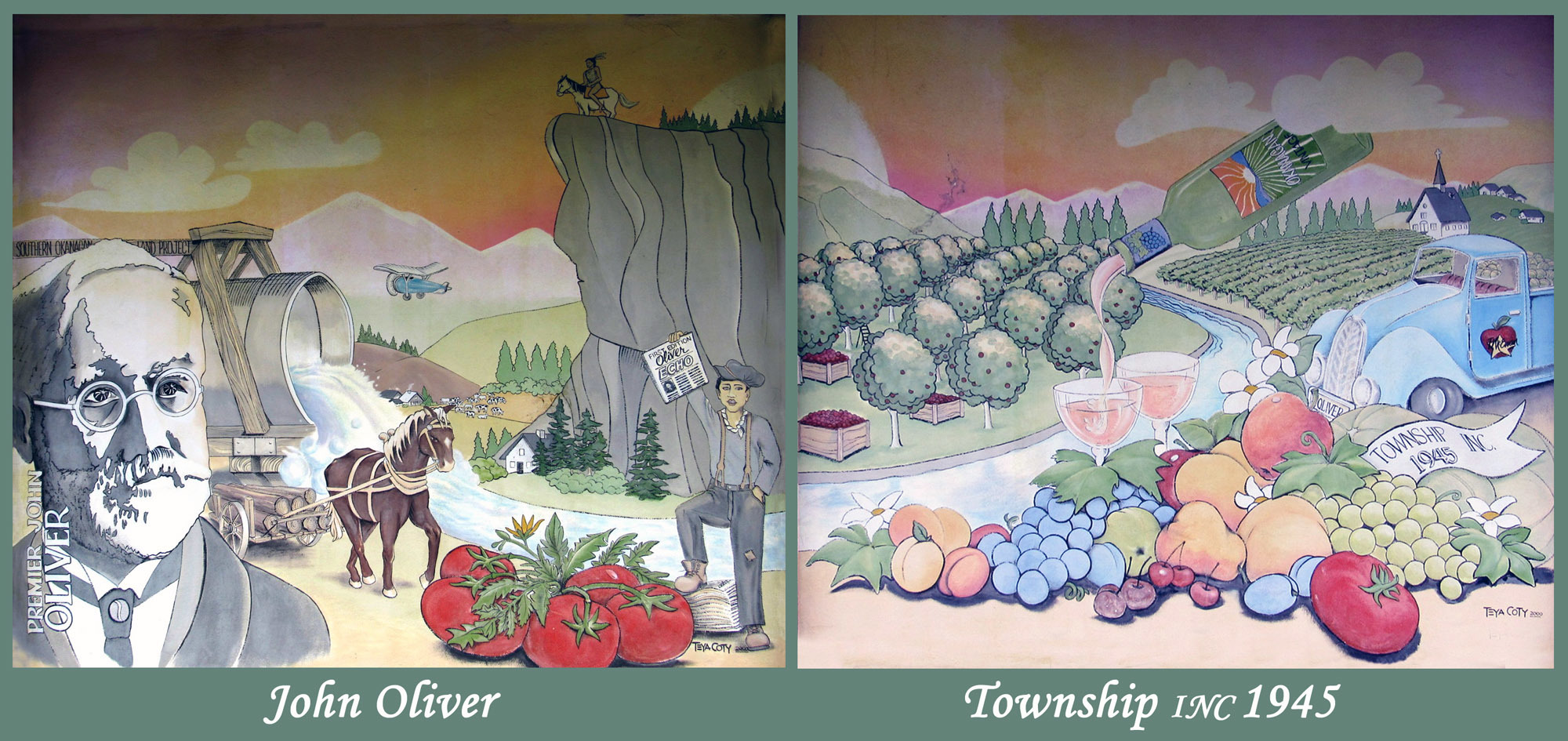
The town of Oliver was named for John Oliver, British Columbia premier also known as Honest John for his outspoken manner, straight talking and his vision for making this area a mecca for farming, fruit and vegetables and now for prize winning vineyards in the Okanagan.
"Following the First World War, BC’s premier, known as “Honest” John Oliver, envisioned an irrigation canal, which would bring this dry Sonora Desert region to life. The South Okanagan Lands Project was born, creating jobs and long term opportunities for veterans returning from World War I. The original townsite of Oliver was surveyed in 1921. Completed in 1923, the concrete irrigation canal (locally known as “the ditch”) soon transformed this desert region into lush orchards and farms."
Source: Oliver

1887: Prospectors stake gold mining claims in the mountains on both sides of the South Okanagan Valley above what was to become Oliver.
1918: Provincial Government purchases 22,000 acres of land in the South Okanagan and proceeds to develop an irrigation system designed to convert some 8,000 acres of desert land, on each side of the Okanagan river, into viable agricultural land and make the land available, at a reasonable cost, to the returning soldiers from World War I.
1926 – 1936: Population of Oliver grown from 500 to 1,800. Many orchards are planted and ground crops in the form of tobacco, tomatoes and cantaloupes and helping bolster the economy. Oliver becomes known as the Cantaloupe Capital of Canada.
1945: Oliver is incorporated into a village.
2021: Oliver Today:
Oliver: Canada's Wine Capital appear on both welcome signs to Oliver. Oliver is a small community with approximately 5,000 residents drawing tourists from around the world. Though Oliver is primarily an agricultural area with an abundance of orchards, and field of vegetables, it is the local wine industry that has boost Oliver's economy. Most of the local wineries offer tours and of course wine tasting. There are bus tours that offer a variety of options throughout the Okanagan Valley.
Oliver's Millennium murals, designed and painted by Teya Coty in 2000 in celebration of the new millennium. There are two murals on the front of the Oliver & District Heritage Society Archives building facing Fairview Road. One of the murals John Oliver, which the town is named and Township Inc 1945 spotlights scenes from its beginning to Oliver becoming Canada's Wine Capital.
Visit Instructions:To record a visit to a Millennium Waymark, please:
Take a photo of the item during your visit.
Describe your visit and what you thought about the item.
Please also mention what you personally did to mark the new Millennium. Was it a night to remember?