
Stollen - Sparnberg an der Saale, Thuringia, Germany
N 50° 24.969 E 011° 45.505
32U E 695961 N 5588538
'Stollen' near Sparnberg, a significant station on 'Saale-Steig'
Waymark Code: WMZJVT
Location: Thüringen, Germany
Date Posted: 11/21/2018
Views: 4
This former mine is unfar Sparnberg, Thuringia at the district road towards Pottiga located. The surrounding is pretty well-known in the geologic fan community.
Description of the location:
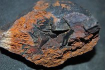
Brown iron stone (> Limonit !) and so-called 'Okererde' are known here at that slagheap. An information paneel descripes the former situation here at the border between Bavaria and Thuringia.
Enjoy your visit here!
(Sources: own research; one picture is adopted by mineralienatlas of Thuringia, other pictures by Waymarkowner)