
Cheyenne County Historical Marker
Posted by:  NevaP
NevaP
N 41° 06.834 W 102° 55.486
13T E 674234 N 4553476
This marker placed by the State of Nebraska Historical Society is located in the I-80 westbound rest Area near Sydney.
Waymark Code: WMYQP
Location: Nebraska, United States
Date Posted: 11/15/2006
Views: 28
The marker is in a pleasant shady area near the parking and service building.
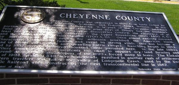
The text of the marker is as follows:
CHEYENNE COUNTY
Cheyenne County was organized in 1870 from lands ceded by the Cheyenne, Arapaho, and Dakota Sioux Indians. In the panhandle of Nebraska, it is part of the Cheyenne tableland portion of the Great Plains. Some fifteen miles west of Sidney lies the landmark, Point of Rocks. Nearby archeological discoveries confirm the existence of at least two prehistoric Indian cultures--the Upper Republican (1100-1400 A.D.) and the Dismal River or Plains Apache (1700 A.D.). Once almost entirely covered by buffalo grass, this region for millennia nourished the American bison. Characterized by limited rainfall and swept by strong winds, this has become a land of broad wheat fields and sprawling cattle ranges. Ranching began in 1869, and by 1882 over two hundred thousand cattle pastured here. In the late 1880's settlers found 160-acre homesteads too small to support dry-land farming and extreme drought and grasshoppers of the 1890's forced many to leave. The Kinkaid Act of 1904, granting 640-acre homesteads, resulted in another rush of settlement. Western travelers will follow the valley of Lodgepole Creek, used by the Union Pacific Railroad when constructing the first transcontinental line in 1867.