
Municipal Park - Comanche, OK
Posted by:  hamquilter
N 34° 21.657 W 097° 57.918
14S E 595148 N 3802663
Comanche's municipal park is one of many built by the WPA in towns around Oklahoma.
Waymark Code: WMYMBQ
Location: Oklahoma, United States
Date Posted: 06/28/2018
Views: 0
The Comanche municipal park is located south of Willow Avenue, between Highway 81, and Old Highway 81. This is a long, narrow grass area primarily serving as a picnic and playground area.
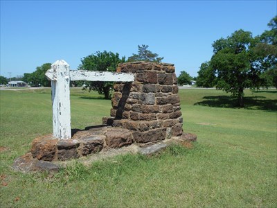
The coordinates above are located at an original WPA-constructed rock sign near the north of the park on Old Highway 81. This is a native sandstone pillar with heavy wood posts to the side which once held a sign.
There are quite a few picnic table which have brick support posts and concrete table tops and benches. Some are in poor condition, and some others have had their concrete tops replaced. There is a pole pavilion with a metal siding roof.
The colorful playground has swings, slides and climbing equipment. The park appears to be used frequently by local citizens.