City Park - Okemah, OK
Posted by:  hamquilter
N 35° 25.750 W 096° 18.199
14S E 744814 N 3923978
The City Park in Okemah was a WPA project in 1935.
Waymark Code: WMYDB6
Location: Oklahoma, United States
Date Posted: 06/01/2018
Views: 2
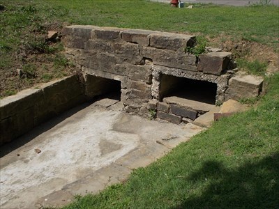
Okemah's City Park is bounded on the north and south by Ash and Beech Streets, between 2nd and 3rd. The park has a picnic pavilion and playground, and basketball court.
For visitors interested in the work of the WPA, you will enjoy viewing the rock drainage ditch which runs through the middle of the park, and the little footbridges that cross it. The original WPA tennis courts are now used for basketball. The land is slightly rolling. On the east side of the park, large stone blocks have been placed along the side of the road. There are stone steps leading up to the road on the south side, and a culvert draining water run-off. Evidence can be seen of old fire pits.